5 PM Friday, January 21, 2022
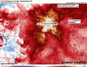
Temperatures are running over 30 degrees warmer at 4 PM today (Friday) compared to 4 PM Thursday in parts of eastern North Dakota with late Friday afternoon temperatures up around 30 degrees!
A narrow band of snow stretching from northeast to southwest Minnesota continues to move to the east late this afternoon. There isn’t a whole lot showing up on radar imagery behind this initial band of snow so will just have to wait and see how much additional snow develops this evening behind this initial wave of snow.
MRMS radar loop ending 4:50 PM Friday.

Snow this evening with snow ending from west to east later this evening through early Saturday morning.
18z NAM 3km model simulated radar forecast ending 6 AM Saturday (snow in blue colors)

Still looking at a widespread 1 to possibly 2 inches of snow in the Northland tonight, but this all depends on how much more snow redevelops through this evening, if we don’t see much more development, then most of us will likely end up with <1″ of snow tonight.

It’s been a windy Friday in the Northland as we get a brief push of warm air advection up into our area. That low level jet (850mb wind) is howling today with speeds >60 knots from eastern Minnesota into western Wisconsin, and some of this wind has been mixing down to the surface which has led to strong wind gusts of 30-45 mph from the south this afternoon.
This warm air advection pattern won’t last long though as will see another albeit brief shot of cold air advection occur on Saturday.
Peak Wind Gusts from today, Friday, January 21, 2022
Duluth Airport: 43 mph
Hibbing, MN: 42 mph
Brainerd, MN: 40 mph
Ashland, WI: 40 mph
International Falls, MN: 38 mph

Saturday night is looking frigid once again with lows in the teens and 20s below zero in northeast Minnesota and northwest Wisconsin with a few 30s below possible in the typical cold spots. Wind chill headlines may be needed for parts of the Northland for Saturday night.

SATURDAY CLIPPER
As tonight’s clipper moves away another clipper low will be hot on its heels, but this one still appears to be taking a more southerly route through South Dakota, and the result from this more southerly track should be to keep the snow away from most of the Northland, although a little snow may clip far southern portions of the area (south of a line from the Brainerd Lakes to Hinckley to Siren) late Saturday afternoon/Saturday evening but accumulations are forecast to be <1″.
Note: Most of the snow with Saturday’s clipper is forecast to fall in that black outlined area on map.

SUNDAY CLIPPER
Our third and final clipper low in this latest set of clippers is forecast to dive SE out of northern North Dakota on Sunday — This one may bring accumulating snow to a larger portion of the Northland due to its more northerly track, with this snow hitting Sunday afternoon into early Monday morning. Early snowfall estimates from this clipper look to be in that 1 to 3 inch range.

Thanks for reading!
Tim
Leave a Reply