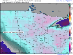
5:49 PM Tuesday, January 25, 2022
It’ll be another frigid night in the Northland under mainly clear skies. Lows will be in the teens, 20s and 30s below zero.
Will see warmer temperatures on Wednesday, but to go along with these warmer temps will be a gusty southerly wind which kicks in mid to late Wednesday morning through Wednesday afternoon.
Another shot of cold arctic air returns Thursday and Friday with subzero overnight lows likely, although daytime highs on Thursday and Friday are still expected to get into the teens above zero.
Not a whole lot of snow is expected in our area for the rest of January with our best shot at getting some snow coming Wednesday night, but amounts look light and generally <1″.
Dangerously cold wind chills are likely once again tonight with wind chill values ranging from around -25 to -45 degrees in northeast Minnesota and northwest Wisconsin.
A Wind Chill Advisory covers all of northeast Minnesota and northwest Wisconsin through late Wednesday morning.

HRRR model wind chill forecast thru Noon Wednesday.

Note: The warmest part of Wednesday likely won’t be until Wednesday evening or after sunset this is when we may see some 20s in parts of the Northland.

Gusty winds are likely in the Northland on Wednesday due to a tightening pressure gradient between a strong low approaching from the NW while strong arctic high pressure moves SE across the Midwest.
Strong warm air advection will also occur Wednesday which will be replaced with cold air advection Wednesday night and Thursday — These swings in temperatures will also help produce some strong wind gusts Wednesday and also on Thursday.

South to southwest winds of 15 to 25 mph are likely across the Northland during the day Wednesday with gusts >35 mph possible. Patchy blowing snow is possible due to these gusty winds.

Our best chance for getting some snow showers and flurries in our area comes later Wednesday afternoon into Wednesday night.
NAM 3km model simulated radar forecast valid Noon Wednesday to Noon Thursday (snow in blue colors)

Low Temperature Reports from Tuesday morning, January 25, 2022
Ash Lake, MN: -35 F
Crane Lake, MN: -33 F
Seagull Lake, MN: -31 F
2 E Celina, MN: -31 F
3 E Orr, MN: -30 F
Cotton, MN: -30 F
3 E Wright, MN: -29 F
International Falls, MN: -28 F
Aitkin, MN: -27 F
Cook, MN: -27 F
Cass Lake, MN: -26 F
Bigfork, MN: -26 F
Embarrass, MN: -25 F
Littlefork, MN: -25 F
3 SW Butternut, WI: -24 F
Isabella, MN: -24 F
Chisholm-Hibbing Airport: -24 F
Longville, MN: -24 F
Barnes, WI: -23 F
Minong, WI: -23 F
Hill City, MN: -22 F
Grand Rapids, MN: -22 F
Hayward, WI: -22 F
Solon Springs, WI: -22 F
Twig, MN: -22 F
Brainerd, MN: -21 F
Walker, MN: -21 F
3 W Clam Lake, WI: -20 F
Hinckley, MN: -20 F
Grand Marais Airport: -20 F
Cloquet, MN: -20 F
Pine River, MN: -20 F
Two Harbors, MN: -20 F
Duluth Airport: -19 F
Siren, WI: -19 F
Spooner, WI: -19 F
McGregor, MN: -17 F
Moose Lake, MN: -17 F
Glidden, WI: -16 F
Washburn, WI: -16 F
Duluth Sky Harbor Airport: -15 F
Minimum Wind Chill Reports (-35 or lower) from Tuesday morning, January 25, 2022
1 WSW Virginia, MN: -50 F
Orr, MN: -46 F
International Falls, MN: -44 F
Grand Marais Airport: -43 F
Chisholm-Hibbing Airport: -43 F
Cook, MN: -42 F
Duluth Airport: -42 F
Cloquet, MN: -40 F
Grand Rapids, MN: -40 F
Brainerd, MN: -39 F
Isabella, MN: -39 F
Walker, MN: -38 F
Twig, MN: -38 F
Ely, MN: -37 F
Crane Lake, MN: -36 F
Two Harbors, MN: -35 F
Minong, WI: -35 F
Saginaw, MN: -35 F
Snow mid to late next week?
Computer models continue to show a pattern that may become favorable for storm development over the Plains next week, but storm track, timing and the strength of any low pressure system which develops over the Plains is uncertain and this will continue to be the case for several more days, but the pattern for next week is one to keep an eye on as will see a 500mb trough move east across the western U.S. and eventually out into the Plains sometime between February 1-5.

Probabilities for >3″ of snow for mid to late next week are still pretty low in northeast Minnesota and northwest Wisconsin per Euro ensemble model.

And the probabilities for >6″ of snow mid to late next week are even lower in the Northland, so the Euro ensemble model is leaning toward more of a minor snow event (if anything) in our area next week.

Looking at the GEFS model snowfall forecast for mid to late week shows a few members ~6 or 30% of them cranking out 6″ or more of snow (purple colors on the images below) in parts of northeast Minnesota and northwest Wisconsin, while the other 14 members or 70% of them showing lighter amounts of snow in our area.

Thanks for reading!
Tim
Leave a Reply