5:01 PM Tuesday, February 8, 2022
An early spring feel across much of the region today as high temperatures climbed well into the 30s and 40s, with even warmer temperatures in the 50s from southwest Minnesota into southern portions of South Dakota this afternoon.
A few high temperature reports from Tuesday, February 8, 2022
Brainerd, MN: 43 F (Last time at or above 40, 1/18/2022)
International Falls, MN: 40 F (Last time at or above 40, 12/24/2021)
Hibbing, MN: 38 F
Ashland, WI: 34 F
Duluth, MN: 32 F (Last time at or above freezing, 1/18/2022)
Two clippers through late this week.
The first clipper affects the Northland tonight into Wednesday bringing a little snow, gusty winds and cooler temperatures to the area.
A second clipper (stronger of the two) affects our area Thursday afternoon into early Friday morning bringing a period of snow (possibly heavy for a brief period of time) gusty winds, warmer temperatures and perhaps a brief period of mixed precipitation types. A return to arctic air follows this late week clipper from Friday afternoon into Sunday morning.
Here are the tracks of the two clippers this week. Both lows are forecast to remain north and east of our area.

A nice early February day!

A cooler day ahead for Wednesday with highs a good 5 to 15 degrees colder than what we saw on Tuesday.
Highs Wednesday will mainly be in the 20s in northeast Minnesota and in the 20s to around 30 in northwest Wisconsin. Not frigid by any means but throw in a gusty wind and it will feel a tad chilly outdoors on Wednesday.

There is a strong area of low pressure off to our northwest today and this system will continue to track to the east-southeast as it moves across Lake Superior through Wednesday.

A look at today’s system as it moves from southern Manitoba into western Ontario late this afternoon per visible satellite imagery.

Snow showers and flurries are likely in much of the Northland tonight into Wednesday.
Snow will begin first in northern Minnesota this evening, and then will see some snow spread farther south/east into northeast and eastern Minnesota and northwest Wisconsin after Midnight tonight.
Overall, this won’t be a huge snow event anywhere in our area, but there may be just enough snow to cause some slick spots on area roads and reduced visibility at times.
18z NAM 3km model simulated radar forecast thru 6 PM Wednesday (snow in blue colors)
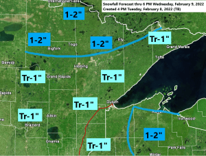
For Duluth — Snow showers and flurries develop mainly after Midnight tonight and continuing throughout the day on Wednesday. Total snowfall accumulations <1″.

Here is my snowfall forecast thru 6 PM Wednesday.

Timing of the late week clipper system
Snow is forecast to spread NW-SE across the Northland between 1 PM and 5 PM Thursday. Snow starts earliest in north-central Minnesota, and latest in northwest Wisconsin.
Snow may be moderate to heavy at times, but the heavier snow won’t last very long, maybe an hour or two in any given location, but a lighter snowfall may linger for several hours once the snow begins.
Snow diminishes from NW-SE later Thursday evening-early Friday morning.
Areas west/south of that black line on the map below may see the snow mix with or change to a brief period of rain, freezing rain or sleet Thursday evening.
For Duluth — Snow begins late Thursday afternoon (~4 or 5 PM) Snow ends late Thursday night (~10 PM to Midnight) Early snowfall estimates for Duluth look to be in that 1-2″ range.

Northern Minnesota and parts of northwest Wisconsin continue to have the highest probabilities for getting more than 3 inches of snow (outlined in black) with the clipper late this week (Thursday/Thursday night time frame)

Thanks for reading!
Tim
Leave a Reply