4:56 PM Wednesday, February 9, 2022
Scattered snow showers and flurries will linger in parts of the Northland this evening otherwise a fairly quite night of weather ahead with lows falling into the single digits below to single digits above zero.
A quiet Thursday morning will turn a little more active once we get into Thursday afternoon as we see our next clipper system approach from the northwest. This clipper will likely produce about a 6-hour period of light snow in the Northland, with a 1-to-3-hour window where we may see moderate to even heavy snow as the strongest forcing passes through our area.
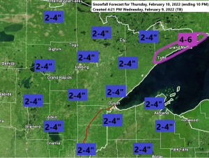
Snow totals should end up in that 2-to-4-inch range in northeast Minnesota and northwest Wisconsin by Thursday evening, but if snowfall rates aren’t overly impressive, and if the snowflakes are relatively small, then the totals will probably be more in that 2-inch range, instead of the 4-inch mark. Larger snowflakes accumulate more efficiently vs. smaller snowflakes, yes snowflake size does play a role in these snow events.
Another shot of arctic air arrives Friday and sticks around into Sunday morning, with Friday night/Saturday morning looking the coldest with lows in the teens and 20s below zero in the Northland.
The clipper system which brought gusty winds, cooler temperatures and some snow showers to the Northland today is exiting off to the east late today, but hot on its heels is a second clipper, and this one is quite a bit stronger and will have more of an impact on our weather Thursday afternoon into early Friday.
Goes-16 water vapor loop from Wednesday, February 9, 2022

TIMING OF THURSDAY’S SNOW
- Snow begins in north-central Minnesota between 11 AM and 1 PM Thursday.
- Snow reaches the North Shore, eastern Minnesota and northwest Wisconsin around 3 PM Thursday.
- Snow ends from NW-SE by mid to late Thursday evening.
For Duluth — Snow starts around 2-3 PM Thursday, snow ends around 7-8 PM Thursday. Bursts of moderate to heavy snow are possible from around 4 PM to 7 PM Thursday.

Here’s my snowfall forecast for Thursday’s clipper.

GUSTY WINDS
Clipper on Thursday will also bring some strong winds to the Northland, first from a southerly direction Thursday afternoon into early Thursday evening, then will see the wind direction shift to the northwest Thursday night. Wind gusts of 20 to 30 mph (possibly as high as 40 mph) are expected in much of northeast Minnesota and northwest Wisconsin from Thursday afternoon through Friday morning. Patchy blowing snow may develop due to the gusty winds.

TEMPERATURES
A real mix bag when it comes to the temperatures on Thursday.
Will start with a cold air mass in the Northland early Thursday afternoon with temperatures in the teens, but a surge of warmer Pacific air will quickly spread ESE out of northwest Minnesota and into much of the Northland Thursday evening into early Friday morning, this is when we may see temperatures rise toward or even above the freezing mark before temperatures tumble once again during the day on Friday as a new batch of arctic air swooshes in.
Note: There continues to be a chance for the snow to mix with or change over to a brief period of rain, freezing rain or drizzle Thursday evening mainly over western/southern portions of the Northland.

Thanks for reading!
Tim
Leave a Reply