7:36 PM Saturday, February 19, 2022
- A prolonged period of snow is possible in parts of the Northland, mainly from east-central Minnesota to the Twin Ports, North Shore, and into northwest Wisconsin from Monday morning into early Wednesday.
- Conditions may become favorable for lake enhanced snow near Lake Superior including for Duluth and the North Shore Monday into Monday night, and for the South Shore from Monday into Tuesday.
- Gusty winds may accompany the falling snow, and with a cold air mass in place, snow that falls should be rather fluffy and easier to blow around.
- Winds may be particularly strong near Lake Superior Monday into early Tuesday this is when we may see wind gusts of 25 to 30 mph or higher out of the east-northeast.
- Winter Storm Watches/Warnings/Advisories will likely be needed for parts of the Northland for the Monday-Tuesday time frame unless computer models trend toward lower snowfall amounts/lesser impacts for parts of our area.
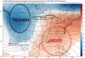
The storm track for early next week remains well to the south of the Northland and typically when a low tracks this far to the south we don’t see any snow or only light snow amounts in northeast Minnesota or northwest Wisconsin, but this system is different as will see a broad 500mb trough covering the western U.S. with favorable jet dynamics and lift well north of the surface low to produce one or two rounds of accumulating snow in much of the upper Midwest and western Great Lakes early next week.

Here’s the latest Euro model run (18z) simulated radar forecast valid from Midnight tomorrow night to 6 AM Wednesday (snow in blue colors)
For Duluth — Snow develops early Monday morning ~4 AM, and once the snow starts it might not stop until early Wednesday morning.

MODEL TRENDS
EPS model has trended slightly farther north with the 6+” snow band for early next week.


And the GEFS model has also trended north with the 6+” snow band for early next week.


Here’s what I have for snowfall totals with next week’s storm, keep in mind these are early snowfall estimates. Snowfall gradients will probably tighten up, while amounts may increase or decrease in later forecasts/updates. Stay tuned.
Note: There is certainly a possibility that snow totals will reach or exceed 12 inches in that 6-10+” zone the way it looks now.
If this system pans out like some of the models are showing today, then we may very well see near blizzard conditions develop near Lake Superior including in Duluth on Monday into early Tuesday, perhaps not due to the intensity of the snowfall, but due to the potential for strong wind gusts which combined with the falling snow may create very poor visibility and possible whiteout conditions at times.

Thanks for reading!
Tim
Leave a Reply