5:02 PM Wednesday, March 2, 2022
As easy as last week’s winter storm was to forecast (none of them are really that easy though), the one this weekend is the complete opposite with major differences continuing to show up when it comes to precipitation totals across the Northland, but hey the computer models do agree very well on the storm track, so there’s that.
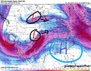
Several pieces of energy approaching from the NW and SW, how do those interact with one another, plus we have a ridge farther to the south/east, what role if any does that play? Still many things for the computer models to sort out.
- Computer models continue to be in good agreement on the track of a low-pressure system this weekend.
- Low pressure is forecast to be over northwestern Kansas around daybreak on Saturday, this low is then forecast to lift northeast, eventually passing through central Wisconsin (north of Green Bay) around daybreak on Sunday.
- What the computer models don’t agree on is the amount of precipitation we see in the Northland out of this storm this weekend.
- European model is the driest model of all and is pretty much all alone with its low precipitation totals that it continues to show (3 model runs in a row) Other computer models such as the GFS, Canadian, UK, and German-Icon (12z run) show much higher precipitation totals occurring in much of the Northland this weekend.
- Looking at the ensemble data reveals more of the same, with the Euro ensemble (EPS) drier compared to the GEFS and the Canadian ensemble model which show higher amounts of precipitation.
- These differences in precipitation amounts are very important to this forecast, as the possibilities range from mostly a minor snow and ice event in northeast Minnesota and northwest Wisconsin per Euro data, vs. a much more impactful winter storm with a swath of heavy snow along with an area of significant freezing rain (ice accumulation)
- My forecast today is leaning more toward the Euro solution although I’m not totally ignoring what the other models show, but past history with these winter storms leads me to believe that the other models will begin to trend toward the Euro solution with time. And of course, a case can be made where the Euro will bust with this storm and cave toward a much more impactful winter storm over the next few model runs, but you really don’t see that happen too often although it does happen once in a while.
As for the timing for when we may see wintry precipitation in the Northland
-An initial burst of snow or freezing rain/drizzle is possible late Friday night into Saturday morning in parts of northeast and east-central Minnesota into northwest Wisconsin.
-A secondary wave of snow, sleet and freezing rain is possible as it spreads from SW-NE Saturday afternoon into Saturday evening with precipitation ending Sunday morning.

Here’s what I have for snowfall amounts this weekend. Changes to this forecast are likely over the next few days so keep checking back for updates.

Freezing rain and sleet are also possible mainly over southern parts of the Northland this weekend, mainly from Saturday into early Sunday morning.

Big time temperature contrast on Saturday as the battle between winter and spring is just getting started.
*Near 60 in far southeast Minnesota
*Mid 60s in southern Wisconsin
*Low 70s in central Illinois
*Near 80 in northeast Kansas, mid 30s in southwest Nebraska
*Teens in North Dakota, 20s in northern Minnesota

Just an incredible temperature gradient in place today.
3 PM temperatures ranged from the teens below zero along the east shores of Hudson Bay Canada, to around 80 as far north as Omaha, Nebraska, while temperatures were in the low to mid 80s in parts of Kansas this afternoon.

Temperatures were running some 25 to 35 degrees warmer than average in the Central Plains this afternoon.

Widespread record or near record warmth across the Plains today.

Thanks for reading!
Tim
Leave a Reply