5:31 PM Thursday, March 3, 2022
A winter storm will bring a variety of precipitation types to parts of the Northland from late Friday night through Sunday morning.
-Freezing rain and sleet continue to look most likely from eastern Minnesota into much of northwest Wisconsin including in the Duluth area.
-The potential for significant ice accumulations reaching or even exceeding one quarter of an inch are greatest in parts of northwest Wisconsin, west into far eastern Minnesota, but at least some light ice accumulation is looking likely as far north as Duluth on Saturday, and those totals may end up higher depending on if we get more freezing rain vs. sleet, as more sleet would cut down on overall icing impacts.
-Gusty winds of 15 to 30 mph out of the northeast on Saturday will become more northerly Saturday night. If ice accumulations become significant enough (around or over a quarter inch) than we may see some scattered power outages develop in parts of eastern Minnesota and northwest Wisconsin Saturday and Saturday night.

Here’s my updated snowfall forecast for this weekend’s storm.
Stay tuned for updates as this forecast may change over the next 24 hours.
Note: Totals an excess of 4″ are possible somewhere in that 2-4″ zone, but there continues to be too many differences on the computer models to determine where that higher snow total area may be.
Most of the snow with this storm looks to fall from mid to late Saturday evening through early Sunday morning.

-Looks dry in all of the Northland during the day Friday.
-Chances for freezing rain, freezing drizzle, sleet and some snow increase late Friday night or early Saturday morning in parts of eastern Minnesota, northeast Minnesota and northwest Wisconsin.
-More rounds of a wintry mix are expected during the day Saturday into Saturday evening with a transition to all snow occurring from west to east Saturday night. Note: There could be brief periods of moderate to heavy precipitation rates especially from Saturday afternoon through Saturday evening from east-central Minnesota into northwest Wisconsin.
-Precipitation is forecast to exit the Northland to the east by around daybreak on Sunday.
Here’s the 18z NAM 3km model simulated radar forecast valid 6 PM Friday to Midnight Saturday night.
Mixed precipitation types in purple and pink colors on the animation below.
Snow in blue colors.

There continues to be a risk for a few severe thunderstorms (yellow area on map) Saturday afternoon into Saturday evening across central and eastern Iowa, far southwest Wisconsin into northern Missouri, and there’s even a chance for a severe thunderstorm as far north as southeast Minnesota (dark green area on map)
Isolated thunderstorms may occur as far north as southern portions of the Northland Saturday into Saturday evening due to steep mid-level lapse rates and some elevated CAPE (instability) which is forecast to push NE out of southern Minnesota during the day on Saturday.

Our weekend storm is just beginning to move ashore in the western U.S. with two main pieces of energy circled in white.
Goes-16 water vapor loop from Thursday afternoon, March 3, 2022.

Computer models along with their ensembles remain in very good agreement regarding the track of a storm this weekend.
Low pressure initially over northwest Kansas around daybreak on Saturday is forecast to lift northeast, reaching northern Iowa Saturday evening and central Wisconsin (north of Green Bay) late Saturday night. Low pressure is then forecast to be over eastern upper Michigan around daybreak on Sunday.

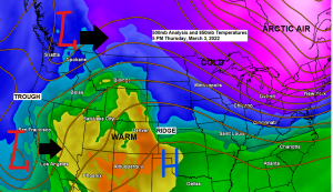
Will see a wide range in temperatures across Minnesota on Saturday ranging from the mid 20s in northwest Minnesota to around 60 degrees in extreme southeast Minnesota with mid 60s as far north as far southern Wisconsin!
High temperatures in the Northland on Saturday are forecast to be in the upper 20s to lower 30s with mid to upper 30s possible in far southern areas of northwest Wisconsin from around Siren to Hayward.

Thanks for reading!
Tim
Leave a Reply