5:53 PM Monday, March 7, 2022
Will be heading back into a northwesterly flow aloft over the next several days. No chance of a major winter storm hitting the Northland as long as we stay in a NW flow, instead will have a clipper or two which could bring a skiff of snow every now and then through early next week, but overall, it’s a pretty dry pattern for northeast Minnesota and northwest Wisconsin.
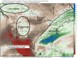
There are hints showing up in the long range for a shakeup in the pattern which could lead to a higher chance for a more significant system impacting the Northland sometime later next week (~March 17-20), but that is a long way away meaning it could easily change by then.
One of the warmer days this week will come on Tuesday, but after that we’re back into some arctic air, but this will be a late season brand of arctic air, meaning it likely won’t have quite the bite to it during the daytime as long as the sun is shining, as that sun angle continues to get stronger with each passing day as we inch closer to the official start to spring 2022.
Here’s the 500mb height anomaly forecast thru March 12, 2022.
Below normal heights/troughs in blue and purple colors
Above normal heights/ridges in red colors

Temperature anomaly forecast valid March 8, 2022, thru March 13, 2022
Below average temperatures in blue, green and purple colors
Above average temperatures in orange and red and white colors
As you can see there isn’t a whole lot of warmth coming to the Northland at least through Saturday.

***WEATHER HISTORY***
Record high of 70 at Duluth, Minnesota on today’s date (March 7) back in 2000.
Big time warmth east of the Rockies on March 7, 2000.

Seems like we’ve been stuck in a NW flow aloft for about the last 2 or 3 months with just brief changes in the pattern.
NW flow type clipper system moves through the Northland on Tuesday bringing scattered snow showers and flurries to the area.

Simulated radar forecast valid 6 AM Tuesday through late Tuesday night (snow in blue colors)
Although will likely see some snow at times on Tuesday, I’m not expecting much if any accumulation and no real travel impacts from this snow.

A stronger mid/upper-level trough and clipper type system moves SE across the area late this week with another opportunity for a little snow on Friday.

Thanks for reading!
Tim
Leave a Reply