6:06 PM Sunday, March 13, 2022
There is another snow event on the way late tonight through Monday morning, but this one is targeting areas south of Duluth, affecting a small portion of central and eastern Minnesota into north-central and northeast Wisconsin.
The snow band that sets up with tonight’s event will likely be quite narrow, but where it does snow, the snow may be heavy at times for a few hours early Monday morning. Snow is forecast to end by late Monday morning or early Monday afternoon.
Simulated radar forecast through 1 PM Monday (snow in blue colors)

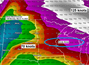
A strong jet streak is one of the ingredients behind tonight’s snow event as will see enhanced lift occur southwest of that 125-knot jet streak, and east-northeast of that 70-knot jet streak coming out of South Dakota.

A look at tonight’s system as seen on Goes-16 water vapor imagery.

This next system is tracking much farther south compared to recent clippers.

Here’s the NWS Blend of Models snowfall forecast through 1 PM Monday.
A narrow swath of 1 to 4 inches of snow stretching from parts of central Minnesota into north-central and northeast Wisconsin, with locally higher amounts possible especially over north-central and northeast Wisconsin.
For the Northland — Up to 2 inches of snow is possible in far southern areas, mostly south of a line from Brainerd to Hinckley to Minong and Hayward. Snow totals taper off considerably just north of that area.

Snow cover will play a role on temperatures this week.
Southern Minnesota currently has little if any snow on the ground, and this will help that area warm well into the 50s and 60s this week (after Monday)
A much deeper snowpack covers the Northland, and the result from this will be for cooler temperatures compared to southern Minnesota, but we’re still looking at a nice warmup this week with daytime highs in the 40s and a few 50s starting on Tuesday. Our deep snowpack should melt somewhat by next weekend.


Temperatures at 6:15 AM Sunday we’re running some 20 to over 40 degrees warmer compared to the same time on Saturday in much of Minnesota into western Wisconsin.

Thanks for reading!
Tim
Leave a Reply