6:05 PM Friday, March 18, 2022
- The weather will remain on the quiet side in the Northland through the weekend.
- Chances for rain, some snow and possibly some freezing rain/sleet are in the forecast for the early to middle part of next week.
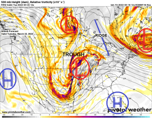
- Major differences continue to show up per model guidance in regard to precipitation totals and precipitation types with the system for next week.
- European and UK models continues to show quite a winter storm in much of the Northland for next Tuesday-Wednesday, while the GFS and Canadian models are a miss, as those models continue to keep this system farther south and away from the Northland with very little precipitation impacting our area.
Here’s a look at the snowfall probabilities for next week per EPS model (aka euro ensemble)
Snow totals >1″

Snow totals >3″

And a look at snowfall totals per 12z GEFS model (aka GFS ensemble model) for next week ending Thursday, March 24, 2022.
Purple colors on the images below represent snow totals of 6″ or more using a standard 10:1 ratio.
The main takeaway from the GEFS model is a lot of uncertainty still exists on how this system evolves for next week.

Temperatures were quite a bit cooler near Lake Superior and in parts of northwest Wisconsin today with highs generally in the low to upper 30s, while temperatures were milder farther inland across north-central Minnesota with highs mostly in the 40s today.

The main reason behind the cooler temps near Lake Superior today was due to the wind direction which was out of the ENE. There was also widespread low-level cloudiness over much of Lake Superior today and those clouds impacted the North and South Shore of Lake Superior today.
Goes-16 visible satellite loop from Friday, March 18, 2022

The bigger weather story today has been a strong area of low pressure which continues to lift NE across the Midwest as seen on Goes-16 water vapor imagery.

Today’s storm has been mostly a rain maker, but there has been some snow in parts of northeast Iowa into southwestern Wisconsin.

Temperatures will be on the mild side this weekend with highs on Saturday in the 40s in northeast Minnesota and northwest Wisconsin, and it also looks like will get rid of the lake breeze on Saturday so temperatures should get into the 40s even near Lake Superior.

Highs Sunday are forecast to the mid 40s to low-mid 50s in northeast Minnesota and northwest Wisconsin, but a lake wind could return by Sunday afternoon and if that happens then will see much cooler temperatures develop near Lake Superior.

Thanks for reading!
Tim
Leave a Reply