6:17 PM Friday, March 25, 2022
A cold and windy weekend ahead with the windiest weather occurring tonight into Saturday with less windy conditions expected Sunday.
Peak Wind Gusts today (through 4 PM)
International Falls 45 mph
Brainerd 45 mph
Duluth Airport 44 mph
Hibbing 43 mph
Ashland 37 mph
Northwest winds gusting 20 to 40 mph will continue in the Northland tonight, with 15 to 30 mph wind gusts Saturday. Note: Even stronger winds are likely along the North Shore of Lake Superior where wind gusts could reach 40 to 50 mph tonight.
Wind gust forecast through 7 AM Sunday.

As I alluded to above it’s going to be a cold weekend in the Northland with high temperatures Saturday and Sunday only in the 20s (normal highs are in the low to mid 40s) with lows tonight in the single digits and teens with even colder temperatures expected Saturday night with lows ranging from around 10 below to 5 above zero, and this is a good 15 to 25 degrees below normal for late March.

Lake effect snow showers will continue tonight into Saturday morning along the South Shore of Lake Superior in northern Wisconsin while snow showers in northeast Minnesota come to an end by later tonight.
Simulated radar forecast through 9 AM Saturday.

Total snowfall through 1 PM Saturday.

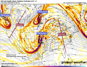
A potent mid and upper-level area of low pressure continues to drop SE across the upper Midwest today per Goes-16 water vapor imagery.

A look at today’s system as it heads SE into northern Illinois on Goes-16 visible imagery.

STORM POTENTIAL CONTINUES NEXT WEEK
Computer models continue to show the potential for another storm to affect the Northland next week (March 29-April 1 time frame)
-Similar to the last storm to affect the Northland, the one next week also looks complex with two main pieces of energy, one over west-central Canada, the other over the southwest U.S.
-Do those lows phase which then leads to a very strong storm over the Great Lakes late next week, or do the lows stay separate leading to a weaker system overall.
-Currently the possibilities for next week include this being a very impactful winter storm for northeast Minnesota and northwest Wisconsin with a potential for heavy snow, strong winds and ice, to more of a minor to moderate snow and ice event, and since this potential storm is still a good 4-5 days away, we could see the storm track shift farther south and away from the Northland with no impacts at all for our area.
The trend seen today in the 12z model guidance from the European, GFS and Canadian models is for a more phased system (stronger storm) lifting NE into the Great Lakes later next week.
Stay tuned!

Probabilities for accumulating 6 or more inches of snow have increased in much of the Northland for next week compared to 24 hours ago.

Currently there are 44 out of 50 members (88%) showing snow totals of 6″ or more next week, while 31 out of 50 members (62%) show double digit snow totals in Duluth next week.
This is pretty crazy considering the storm for next week is still several days away, but to see such strong agreement already in snowfall totals is eye opening.
Here’s the 50 member EPS (Euro ensemble model) snowfall forecast for Duluth, Minnesota.

Here’s the 12z GEFS model 20-member snowfall forecast for next week using a 10:1 ratio.
Purple colors on the images below represent snow totals of 6″ or more.
Only 1 member out of 20 shows this storm missing the Northland next week, again that’s pretty impressive to see for a system which is still several days away.

Freezing rain (ice accumulations) could be a major element to next week’s storm
At the moment the greatest threat for ice accumulations next week, possibly significant amounts of greater than a quarter inch stretches from east-central Minnesota into much of central and northern Wisconsin into upper Michigan per EPS model.
Ice totals for Duluth range from a low end of 0.00″ to a high end of 0.53″ next week.

Impressive amounts of liquid equivalent precipitation totals for next week using a blended model approach.

Thanks for reading!
Tim
Leave a Reply