5:38 PM Saturday, March 26, 2022
Model trends for next week’s storm.
-A slightly faster moving system.
-Possibility for a later interaction/phasing between the northern wave and southern wave which could help pull the storm track even farther S/E from what the models are forecasting today.
-Still a chance that we don’t see any phasing occur between the northern wave and southern wave which could lead to a weaker system overall, this is most evident on the German-Icon computer model today, and if that solution verifies, then whatever precipitation we see in the Northland would come Tuesday afternoon into early Wednesday morning and that would be it for the rest of the week.
We’ve seen a decrease in precipitation totals and snowfall totals in Duluth with next week’s storm per ensemble model data, however, precip and snowfall totals remain on the high side, just reduced a bit from 24 hours ago, but does this trend continue the next few days where we see a further reduction in precip/snowfall totals in Duluth, that is definitely a possibility. The trend is certainly going down not up over the last 3 model runs when it comes to precipitation totals.
The three ensemble models include the EPS, GEFS and CMCE.
12z run from 3/25
Total Precipitation: 1.50″
Total Snowfall: 10.5″
00z run from 3/26
Total Precipitation: 1.27″
Total Snowfall: 8.0″
12z run from 3/26 (newest run)
Total Precipitation: 1.20″
Total Snowfall: 8.5″
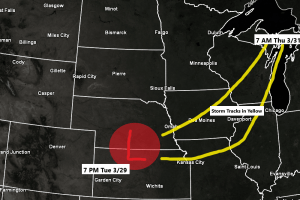
A significant amount of ice from freezing rain remains a possibility with next week’s storm with the highest chances for a tenth to quarter inch or more of ice covering portions of eastern Minnesota into central/northern Wisconsin per EPS model.
The bulk of this freezing rain comes Tuesday night through early Thursday morning the way it looks now.
Total Ice Accumulation for Duluth ranges from a low end of 0.00″ to a high-end amount of 0.41″ per EPS model.

Looking at the 18z Blend of Models still shows a significant amount of precipitation (liquid equivalent) across the Northland next week with amounts ranging from around a half inch in far western areas to over an inch farther east, highest amounts across northwest Wisconsin into adjacent areas of northeast and far eastern Minnesota (purple colors on map)

Probability for accumulating 6″ or more of snow mid to late next week is currently highest near Lake Superior including along the North Shore and South Shore (mainly north/east of Duluth) Lower chances for 6″ or more of snow farther west and south in the Northland next week per EPS model.

60% of the 50 member EPS model shows snowfall accumulations of 6″ or more in Duluth next week, with 30% of the 50 member EPS model showing double digit snowfall totals in Duluth next week — Both numbers are down compared to 24 hours ago.

14/20 or 70% of GEFS members show snowfall totals of 6″ or more in Duluth by next Friday, April 1.
Purple colors on the images below represent snowfall totals of 6″ or more using a 10:1 ratio.

Highest amounts of precipitation so far this month have been across parts of far northern Minnesota and also over parts of northwest Wisconsin – See list below.
Total Precipitation for March 2022 (thru the 25th)
International Falls: 1.21″
Duluth: 0.68″
Brainerd: 0.64″
Hibbing: 0.66″
Ashland: 0.56″

Percent of Normal Precipitation for March 2022 (thru the 25th)
International Falls: 157% of normal
Hibbing: 96% of normal
Brainerd: 89% of normal
Ashland: 66% of normal
Duluth: 61% of normal

Snowfall totals this month have varied considerably, with over a foot of snow so far this month at International Falls, to less than 6″ of snow so far this month at Duluth.
Snowfall Totals and their Percent of Normal for March 2022 (thru the 25th)
International Falls: 15.1″ (221% of normal)
Duluth: 3.6″ (33% of normal)
Thanks for reading!
Tim
Leave a Reply