6:13 PM Sunday, March 27, 2022
A complex storm setup this week, pretty similar to last week.
- Will stay dry in the Northland Monday and through much of the day Tuesday.
- Chances for wet snow, sleet, rain and freezing rain increases in the Northland late Tuesday afternoon or Tuesday evening.
- Wet snow, sleet and freezing rain overnight Tuesday into Wednesday. Precipitation tapers off from SW-NE Wednesday afternoon.
- The potential for freezing rain with ice accumulations ranging from 0.05″ to 0.25″ is greatest in parts of eastern Minnesota into parts of northwest Wisconsin from late Tuesday night into Wednesday morning.
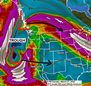
Overall, we have two main pieces of energy, one to the northwest, the other to the southwest (outlined in red on the animation below)
The northern wave drops SE while the southern wave lifts NE through midweek.
How this system evolves mid to late week will determine if the Northland is impacted by a significant storm or not, but the trend over the last 24 hours or so is definitely toward a weaker system impacting the Northland, while a stronger southern wave tracks too far south/east of us to give us much additional precipitation past Wednesday.

The northern system is forecast to more or less become absorbed by the southern system sometime on Wednesday while a broad upper-level trough digs SE into the upper Midwest and Central Plains.
Our best shot for getting some precipitation in northeast Minnesota and northwest Wisconsin will be with that northern system, and timing of that precipitation looks to be from Tuesday evening into Wednesday.
Precipitation associated with that southern system looks like it will miss the Northland to the east during the Wednesday night-early Friday morning time frame. All of this could change, however, if we see that southern system track farther northwest, if that happens then our chances for getting more precipitation would increase in at least parts of the Northland Wednesday night-early Friday morning. The NAM model (18z run) from today seems to hinting at that potential for a more NW track to the low mid to late week, but the NAM has a tendency of being a garbage computer model beyond 36 hours.
This map may be a little confusing, but I tried to make it as simple as I could.
Two main lows and the storm tracks/timing of both lows.

Simulated radar forecast valid 7 AM Tuesday to 7 PM Wednesday per 12z European computer model.
Snow (blue)
Rain (green)
Mixed precipitation (pink and purple)

Here’s my preliminary forecast of snow and sleet accumulations valid Tuesday night through Thursday afternoon.
For Duluth — 2 to 4 inches of total snow and sleet accumulation, most of this falls Tuesday night into Wednesday.

Model Trends for Snowfall at Duluth — Trend continues to be toward lower snow amounts.
19/50 or 38% of EPS model members (12z run from Sunday) forecast 6″ or more of snow in Duluth this week, this is down from 48% per 00z run last night, and down from 60% per 12z run from Saturday.
4/50 or 8% of EPS model members (12z run from Sunday) forecast 10″ or more of snow in Duluth this week, this is down from 14% per 00z run last night, and down from 30% per 12z run from Saturday.
ICE ACCUMULATION POTENTIAL
A significant amount of ice (up to a quarter inch accumulation) due to freezing rain remains a possibility in parts of the Northland, mainly over parts of northwest Wisconsin, and possibly into far eastern Minnesota from late Tuesday night through Wednesday morning.
For Duluth — EPS model ice accumulation forecast ranges from a low-end amount of 0.00″ to a high-end amount of 0.42″.

The Northland has been stuck in a pretty cold weather pattern for a few months now.
You have to go back to December 2021 for the last time the Northland had an average monthly temperature which finished warmer than average.
Here are the Monthly Temperature Departures at Duluth, Minnesota
January 2022: -6.5 degrees below average
February 2022: -9.5 degrees below average
March 2022 (thru the 26th) -1.7 degrees below average


Thanks for reading!
Tim
Leave a Reply