5:35 PM Wednesday, March 30, 2022
Some nicer weather is on the way after today’s early spring winter storm which produced up to a quarter inch of ice accumulation in parts of the Northland, and around a half-foot of wet snow in other parts of the Northland, and we even saw a few thunderstorms for the first time this year in parts of northwest Wisconsin last night all associated with this dynamic spring storm!
Temperatures will remain below normal on Thursday with highs in the 30s to around 40 degrees on the final day of March 2022, but I think will see some partial sunshine develop as the day wears on, but it will be blustery on Thursday with a northerly wind gusting 15 to 30 mph.
Temperatures will finally warm up a bit Friday and Saturday with high temperatures climbing back to where they should be at this time of year (highs in the 40s).
We do have two more systems, however, which could bring a little rain or wet snow to some parts of the Northland. The first would be in the Friday evening-early Saturday time frame, the second in the late Sunday-early Monday time frame. Neither one of these systems look very impressive at the moment, but they could drop a light coating of slushy snow in some parts of the Northland assuming they affect our area.
Still no signs of a significant warmup (highs in the 50s or warmer) in our area at least for the next 10 days which will take us to April 9.
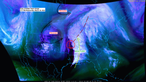
The first part of this two-part storm is wrapping up in the Northland late this afternoon as an area of low pressure along the Wisconsin-Illinois border more or less gets absorbed by a stronger low which is lifting quickly to the NE out of Arkansas late this afternoon.
Goes-16 visible satellite loop from Wednesday afternoon, March 30, 2022.

Water vapor loop showing a large and rather complex storm which stretches from the Great Lakes to the Gulf Coast today, pretty cool!

Snowfall Reports from around the Northland from Tuesday night-Wednesday, March 29-30, 2022.
3 SSW Wirt, MN: 7.5″
3 WNW Squaw Lake, MN: 6.0″
Bigfork, MN: 6.0″
Marcell, MN: 5.0″
1 WNW Cass Lake, MN: 5.0″
3 ESE Orr, MN: 4.2″
3 NNW Mahtowa, MN: 3.9″
3 ENE Holyoke, MN: 3.5″
Big Falls, MN: 3.5″
Cloquet, MN: 3.5″
Duluth, MN (Airport) 3.1″
Foxboro, WI: 3.1″
2 WNW Duluth, MN: 3.0″
West Duluth, MN: 3.0″
Moose Lake, MN: 3.0″
Ely, MN: 2.8″
7 WSW Pine River, MN: 2.5″
Two Harbors, MN: 2.4″
2 SW French River, MN: 2.3″
2 SE Duluth, MN: 2.0″
3 N Amnicon Falls State Park, WI: 1.9″
3 E Payne, MN: 1.8″
1 N Ashland, WI: 1.7″
2 N Moquah, WI: 1.6″
2 SE Spooner, WI: 1.5″
1 E Hertel, WI: 1.3″
Ice Accumulation Reports from around the Northland from Tuesday night-Wednesday, March 29-30, 2022.
Ojibwa, WI: 0.38″
1 NNW Castle Danger, MN: 0.25″
2 SW Bayfield, WI: 0.25″
4 WNW Red Cliff, WI: 0.25″
4 ENE Nisswa, MN: 0.20″
1 NW Manitowish, WI: 0.15″
1 SSE Hawthorne, WI: 0.13″
5 NE Cohasset, MN: 0.13″
2 WSW Lester Park, MN: 0.13″
Duluth, MN (Airport) 0.10″
Gile, WI: 0.10″
3 ENE Holyoke, MN: 0.10″
Silver Bay, MN: 0.10″
2 WSW Superior, WI: 0.10″
1 SSW Superior, WI: 0.06″
4 NW Minong, WI: 0.05″
3 NNW Mahtowa, MN: 0.03″
3 E Payne, MN: 0.01″
- A new 24-hour snowfall record was set at Duluth, Minnesota for today, Wednesday, March 30, 2022. New record 3.3″, old record was 3.0″ set on 3/30/1948.
- March 2022 will be the 6th consecutive March with below average snowfall at Duluth — March 2016 was the last time we had above average snowfall for the month of March.
- Only one day at or above 50 degrees this month at Duluth — Normal in March is 4 days at or above 50 (1991-2020 climate period).
We could be looking at another messy system affecting parts of the Northland next week (~April 5-7), but a lot of uncertainty remains on how this system evolves and how it will track, and if it does affect the Northland would it bring rain or wet snow or a little bit of both? Stay tuned.
Here’s the EPS model 500mb forecast valid April 5-8, 2022 — Blue and green colors on the animation below represents a trough/unsettled weather.

500mb forecast valid Wednesday, April 6, 2022.

Thanks for reading!
Tim
Leave a Reply