6:18 PM Friday, April 1, 2022
Two low pressure systems will be making their way through the Northern Plains and Midwest through early Monday morning, both of these systems will likely affect at least southern parts of the Northland or from eastern Minnesota into northwest Wisconsin.
The first system moves through tonight, the second Sunday night. Wet snow or a rain/snow mix will likely occur with both systems, but no major snow accumulation is expected anywhere in the Northland through Monday morning, instead we’re looking at snowfall accumulations when you combine both events ranging from a dusting to 2 inches for locations that do see mostly snow, and whatever snow does fall tonight will likely melt by Saturday afternoon, likewise with any snow accumulation we see Sunday night will likely be gone by Monday afternoon.
A more significant snowfall (2-5″ accumulation) is possible late tonight through Saturday morning in parts of northeast Iowa and southern Wisconsin.

There is some disagreement in the computer models on how far north the precipitation will get tonight, with the majority of the computer models keeping the precipitation south of the Twin Ports, but if we do get some wet snow or rain in Duluth and Superior tonight it looks to be in the 11 PM to 2 AM time frame.
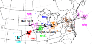
Simulated radar forecast ending 7 AM Saturday.
Snow (blue)
Rain (green)

Tonight’s system looks pretty strong on visible satellite imagery this afternoon with a nice swirl in the clouds showing up over Manitoba, but the main lift associated with that low will remain north of the border tonight.

We’re looking at a disjointed system tonight, with one piece of energy over Manitoba, the other over the Central Plains and that system will pass well south of the Northland tonight.
Water vapor loop from Friday, April 1, 2022.

STORM POTENTIAL NEXT WEEK
A strong area of low pressure is forecast to move into southwest Canada early next week. This low is then forecast to move east-southeast into the Northern Plains, Midwest and Great Lakes by mid to late next week.
-Still seeing considerable uncertainty in the computer models regarding the storm track next week.
-Temperatures aloft do look cold enough at the moment for precipitation to fall as snow, but temperatures near the surface look borderline to where we could see rain, snow or a combination of the two.
-The spread in snowfall amounts in Duluth next week ranges from 0″ to 21″ per EPS model, with 34% of the 50 member EPS model showing snow amounts of 6″ or more, while 20% of the 50 member EPS model shows snow amounts of 10″ or more.
-The operational Euro model (single model run, not an ensemble model) shows a snowfall total of 26″ in Duluth next week, and it’s interesting to note the Euro model has been showing a ridiculous amount of snow in Duluth next week for a few days/model runs now, with more runs than not showing snow totals of 12″ or more since March 29, but today’s run upped the amounts even more! Also interesting to note the Euro model did a poor job with the last storm to hit Duluth with snow totals way too high compared to what actually fell in Duluth.
Shown below is the Ensemble model storm track for next week with the yellow lines representing the spread in the storm tracks.
Stay tuned!

Thanks for reading!
Tim
Leave a Reply