6:25 PM Friday, April 8, 2022
After days of clouds, snow, rain and gusty winds it sure was nice to finally see the sun again in most of the Northland today.
Another nice spring day is on the way for Saturday, but this will be followed by two more low pressure systems which look to affect the Northland, with the second system being the stronger of the two.
The first system crosses the Northland Sunday afternoon through Monday morning and this system could bring some rain and another round of accumulating wet snow to north-central and northeast Minnesota with the greatest snowfall accumulations looking to setup NW of the Twin Ports.
A second and much stronger system hits mid to late next week, but the trend in model guidance is for a more NW track to this system. What that means is that a lot of the precipitation we get in the Northland should be in the form of rain with a band of heavy snow (possible major winter storm) setting up over parts of the Dakotas into northwestern Minnesota the way it looks now.
With the system later next week trending more to the NW, this does increase the potential that will see a few thunderstorms in the Northland especially next Wednesday when instability will be at its max.
Depending on how far north the warm sector of this system gets will determine whether or not any severe thunderstorms develop in parts of the Northland next Wednesday, although at the moment it still looks like most of the severe weather would be farther to our south, since our area will remain on the cooler side of this storm with mostly elevated CAPE (instability) pushing north into our area.
Precipitation Stats for Duluth, Minnesota
- 11.0″ of snow so far this month (thru April 8) Percent of normal snowfall for April 2022 (thru the 8) 355% of normal.
- 4.68″ of precipitation so far this year, this is +0.69″ above normal to date. Percent of normal precipitation for 2022 (thru April 8) 117% of normal.
- The last two years had well below normal precipitation, with the deficit for 2021 at -5.47″ below normal, and in 2020 -9.70″ below normal. Combining those two years and we were -15.17″ below normal in precipitation. 2022 has been quite a bit more active so far, and this is about the only way we’re going to erase the large precipitation deficit/drought we’ve had in the Northland over the last two years.
The large and slow-moving spring storm which affected the Northland over the last few days has finally moved far enough to the east to allow for widespread sunshine to return to northeast Minnesota and far northwest Wisconsin, while the last remnants of this spring storm lingered in eastern parts of northwest Wisconsin with mostly cloudy skies along with some more snow showers mainly south/east of Ashland.
Note: The 3-Day Precipitation Total at Duluth from April 5-7, 2022, 1.29″ with 8.0″ of snow.
Goes-16 visible satellite loop from Friday, April 8, 2022.

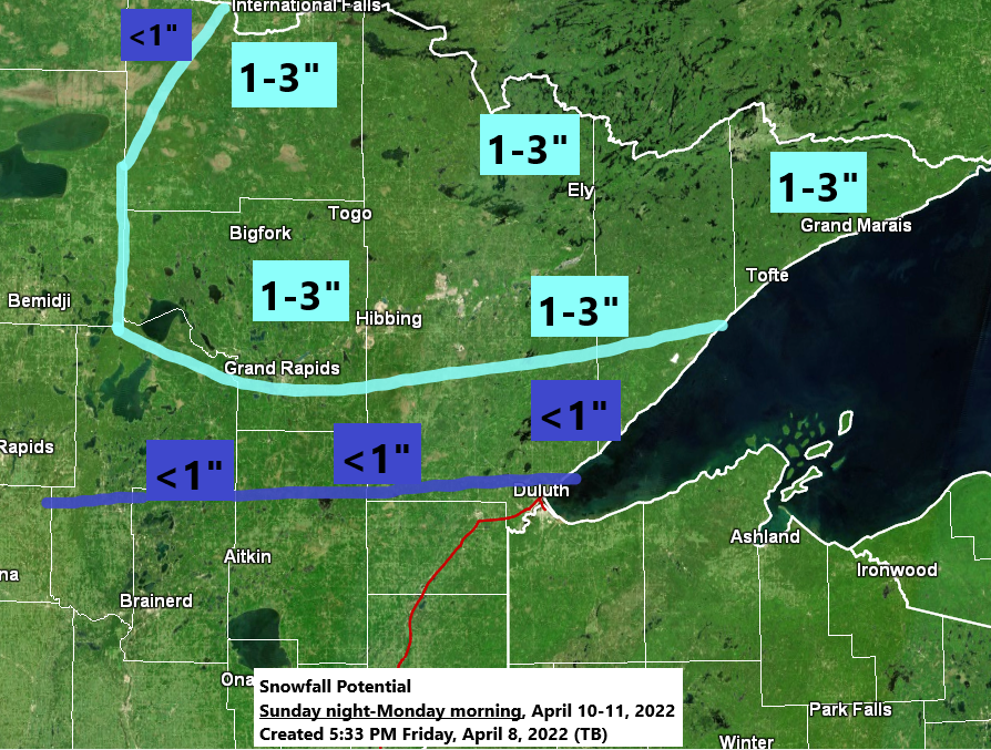
SUNDAY NIGHT STORM POTENTIAL
A lot of sunshine is on the way for Saturday with highs in the middle 40s to around 50 in northeast Minnesota and northwest Wisconsin but will see some changes take place on Sunday as a quick moving but rather strong low-pressure system lifts NNE out of Kansas.
This system looks like it will bring some rain and wet snow to the Northland Sunday into Monday morning with the main time frame for where we could see some accumulating slushy snowfall occurring Sunday night through Monday morning, and those chances for accumulating snow are highest in parts of north-central into northeast Minnesota (generally north of Duluth)

For Duluth — Some rain is possible at times Sunday afternoon with another round of rain or a mix of rain and snow Sunday evening into early Monday morning. Total snowfall accumulations of less than an inch. Gusty east winds are possible Sunday afternoon through Sunday night with wind gusts of 20 to 30 mph.
Simulated radar forecast valid 7 AM Sunday to 1 AM Monday
Rain (green)
Snow (blue)

A STRONG SPRING STORM NEXT WEEK
Computer models continue to show a strong trough and area of low-pressure ejecting NE out of the Rockies next week. It should be noted that the GFS model isn’t nearly as strong or deep with next week’s trough and low compared to the other computer models, and this has been a fairly consistent signal showing up via GFS model. If the GFS solution verifies then we’re looking at a much quicker moving system with most of the precipitation in the Northland falling Tuesday afternoon-early Wednesday.
Storm Impacts for next week
- Heavy snow with possible blizzard conditions in the colder air NW of the surface low track.
- Severe thunderstorms including a risk for some tornadoes in the warmer air SE of the surface low track.
Currently it looks like the Northland will be on the cooler side of this storm, but not quite cold enough to where will see a major winter storm (heavy snowfall) Instead, it looks like will see mostly rain in northeast Minnesota and northwest Wisconsin from Tuesday night through Wednesday night with a possible changeover to some wet snow occurring next Thursday-Friday on the backside of this system.
A few thunderstorms are possible as well in parts of the Northland especially Wednesday and Wednesday night as we could get enough elevated instability to push northward into our area, but severe weather is not expected this far north the way it looks now, but things could change the next few days.

An inch or more of precipitation is possible across all of the Northland through next Friday.

Strong winds are also possible with the storm next week with easterly winds 20 to 30 mph from Tuesday night through Wednesday night, with even stronger wind gusts possible near Lake Superior.
Gusty winds could linger into late next week but there is uncertainty on the storm track and timing which will play a role on how strong winds are in the Northland past Wednesday.
Wind Gust forecast valid 7 PM Tuesday to 7 PM Thursday.

We’re in quite an amplified pattern right now with a big ridge out west and a strong and large trough stretching from the Great Lakes to the Southern and Eastern U.S. today.
Temperatures are close to 80 degrees in parts of Montana today with 60s and 70s extending north into parts of Alberta and Saskatchewan Canada. Temperatures in the 90s to around 100 degrees were common in parts of the Southwest U.S. today.


Thanks for reading!
Tim
Leave a Reply