5:57 PM Monday, April 18, 2022
Official snowfall total at Duluth from Sunday night-Monday morning was 3.9″, but snowfall totals did vary throughout the city with up to 5″ of snow reported in the Lester Park area, and 4″ of snow in the Gary New Duluth area.
April snow stats for Duluth, MN.
Month to date snowfall total: 19.2″ (April 2022 would rank as 7th snowiest April on record if the month ended today). Normal snowfall in April is 9.1″.
Percent of normal snowfall for April 2022, 291% of normal to date (well above average!)
9 one inch or greater snowfall events so far this month. Average in April is just 2 one inch or greater snowfall events. Record is 9 one inch or greater snowfall events set in April 2013.
Top 10 snowiest Aprils on record at Duluth, Minnesota
1) 50.8″ set in 2013
2) 31.6″ set in 1950
3) 26.3″ set in 2014
4) 24.4″ set in 1961
5) 23.7″ set in 1987
6) 20.4″ set in 1972
7) 19.0″ set in 1989
8) 18.5″ set in 2018
9) 18.0″ set in 1983
10) 16.2″ set in 1995
Note: 2021-22 Seasonal Snowfall total at Duluth is now at 94.2″, this is +19.8″ more snow compared to what we had last year at this time. Percent of normal snowfall for 2021-22, 108% of normal to date.
- A brief break in precipitation Tuesday with some sunshine and lighter winds compared to Monday’s windy weather. Highs Tuesday will mainly be in the low to mid 40s, still below normal but at least a little closer to normal for this time of year.
- Another system brings widespread precipitation to the Northland Wednesday.
- Significant snow accumulations are possible Wednesday mainly over the Arrowhead and parts of northern Minnesota. Currently it looks like the highest chances for >4″ snowfall on Wednesday will remain north of Duluth.
- A strong spring storm this weekend with periods of rain along with some thunderstorms and gusty winds.
A wet pattern sticks around through this weekend with widespread precipitation totals of an inch or more expected in northeast Minnesota and northwest Wisconsin.
The main time frames for widespread precipitation looks to be on Wednesday, and again from Friday night through Saturday night.

A look at how much snow fell with last night’s storm.

Snowfall Reports from around the Northland for the April 17-18, 2022, Winter Storm.
4 NE Grand Marais, MN: 7.3″
2 NNE Duluth, MN: 5.8″
3 NE Tofte, MN: 5.0″
1 E Hibbing, MN: 5.0″
4 ENE Lutsen, MN: 5.0″
Keewatin, MN: 5.0″
Nashwauk, MN: 5.0″
Cotton, MN: 5.0″
3 NE Knife River, MN: 5.0″
1 SSW Lester Park, MN: 5.0″
3 W Lester Park, MN: 5.0″
12 N Grand Rapids, MN: 5.0″
3 ENE Island Lake, MN: 5.0″
1 WSW Two Harbors, MN: 4.5″
Silver Bay, MN: 4.5″
Virginia, MN: 4.5″
1 WSW Blackberry, MN: 4.5″
4 NE Munger, MN: 4.3″
1 NNE Spooner, WI: 4.0″
Gary New Duluth, MN: 4.0″
3 NNE Duluth, MN: 4.0″
Effie, MN: 4.0″
Chisholm, MN: 4.0″
2 NE West Duluth, MN: 4.0″
Iron Junction, MN: 4.0″
Grand Rapids, MN: 4.0″
1 SSE Oulu, WI: 4.0″
2 W Iron Junction, MN: 4.0″
Duluth Airport: 3.9″
International Falls, MN: 3.8″
Washburn, WI: 3.5″
Foxboro, WI: 3.5″
Littlefork, MN: 3.5″
Palisade, MN: 3.3″
3 N Amnicon Falls State Park, WI: 3.2″
1 N Cloquet, MN: 3.0″
5 NNE Cook, MN: 3.0″
Hill City, MN: 3.0″
Winton, MN: 2.4″
Barnum, MN: 2.0″
Mason, WI: 2.0″
Marcell, MN: 2.0″
2 SSW Superior, WI: 2.0″
A look at the timing of our next system.
Rain or snow moves into the Northland Wednesday morning (between 4 AM-10 AM)
Heaviest precipitation rates are expected from about mid-morning Wednesday through about mid-afternoon Wednesday.
Precipitation ends from west to east Wednesday evening.
Snow (blue)
Rain (green)
Mix rain/snow (pink)
Simulated radar forecast valid 1 AM Wednesday to 10 PM Wednesday.

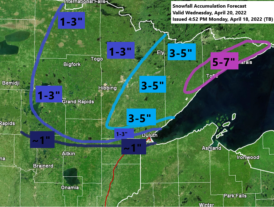
Here’s my preliminary snowfall forecast for Wednesday.
One thing to keep in mind is that this snow will fall during the daytime hours (warmer part of the day) unlike last night’s system which hit overnight (cooler part of the day), whether or not this has an impact on actual snow accumulation remains to be seen, but there is a chance that at least some of the snow that falls on Wednesday melts on contact, but if snowfall rates are intense enough, then none of this will matter a whole lot.
Note: At the moment I’m going with around an inch of slushy snow in Duluth on Wednesday, with 1-3″ of snow just north of the city, and even higher amounts possible a little farther north.

A look at our current system via Goes-16 visible satellite imagery.
Low pressure has moved well to the SE into Lower Michigan this afternoon, but moisture wrapping around that low kept clouds along with scattered snow and rain showers going in much of the Northland this afternoon.

Snow cover after Sunday’s winter storm shows up nicely in North Dakota this afternoon via Goes-16 Day Cloud Phase satellite imagery.

After the midweek system, will have one more to keep an eye on this weekend as a strong area of low-pressure tracks NE out of the Rockies.
Right now, it looks like the majority of the precipitation that we get in the Northland will be in the form of rain from Friday night through Saturday night with a chance for some thunderstorms too as some elevated CAPE (instability) builds north out of southern Minnesota.
We could see some snow, or a rain/snow mix develop late Sunday or next Monday on the backside of this low-pressure system as colder air moves into the area.

There is some uncertainty on the track of this weekend’s system including how far north the warm front will get, and the timing of a cold front, but if things work out just right, then much of Minnesota and Wisconsin may finally get a taste of real spring weather for a day on Saturday with highs in the 70s to around 80 degrees, but it will be much cooler near Lake Superior and in Duluth due to a gusty northeast wind, but that shouldn’t come as much of a surprise.

Thanks for reading!
Tim
Leave a Reply