6:23 PM Friday, April 22, 2022
Another strong spring storm will be impacting the Northland this weekend as an active pattern continues!
There continues to be signals showing up in model guidance for some very heavy rainfall amounts in parts of the Northland tonight through Saturday morning, but where exactly this sets up is a little uncertain as of late this afternoon, but it currently looks like parts of north-central Minnesota and perhaps farther south into east-central Minnesota has the best chance for excessive rainfall amounts tonight, and this may lead to some flooding issues overnight into at least Saturday morning. Note: The potential for flooding could increase if we see thunderstorms move over the same locations for a few hours tonight.
Will be adding to these already impressive precipitation totals we’ve seen so far this month — Total precipitation and percent of normal for April 2022 (thru 4 PM on the 22nd).
International Falls: 3.22″, 282% of normal
Duluth: 2.79″, 157% of normal
Ashland: 2.36″, 155% of normal
Hibbing: 1.90″, 174% of normal
Brainerd: 1.14″, 107% of normal
A slight (yellow area) and marginal (green area) risk for rainfall amounts to exceed flash flood guidance through 7 AM Saturday from central and eastern North Dakota into north-central and northeast Minnesota.

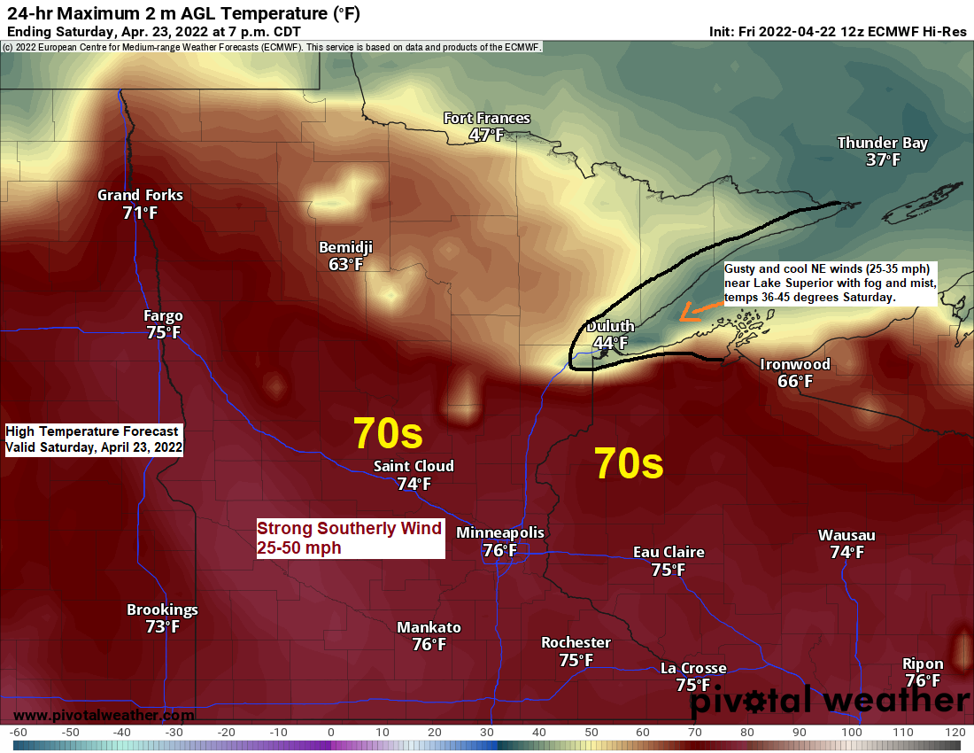
Note: How warm parts of the Northland will get on Saturday will depend on where a warm front sets up. There continues to be a possibility that temperatures will warm into the 60s to lower 70s at least in southern parts of the area, from the Brainerd Lakes to Hinckley, east into parts of northwest Wisconsin, but these warmer temperatures may not occur until later Saturday afternoon, before then temperatures could be quite a bit cooler. One thing appears certain and it’s that locations near Lake Superior including Duluth won’t be getting into this warmer air mass on Saturday.
The threat for heavy rain is certainly there in parts of the Northland tonight.
Ingredients for heavy rain.
1 – Warm front lifting slowly north out of Nebraska and Iowa. Atmospheric lift well north of that boundary will increase tonight causing showers and thunderstorms to become more widespread in the Northland.

2 – A strong surge of warm air advection at 850mb.

3 – Strong moisture transport lifting north out of the Central Plains and into the upper Midwest tonight.

4 – A strong low-level jet (850mb wind) helping to advect higher elevated instability northward into the upper Midwest.

A strong mid/upper-level trough is churning NNE across the Central Rockies today with southerly winds east of that trough advecting warm, humid and unstable air north into the upper Midwest while colder northerly flow west of the trough sets the stage for another weekend blizzard in parts of the Northern Rockies and Northern Plains.
Goes-16 water vapor loop from Friday, April 22, 2022.

Thunderstorms are expected in much of the Northland tonight with isolated strong to severe storms possible.
The primary threats with tonight’s thunderstorms will be from heavy rain and lightning but some hail is also possible in the strongest storms, and some of the hail could reach severe criteria (1″ in diameter, quarter size).

A few strong to severe thunderstorms are possible once again Saturday into Saturday evening, but I still think the slight risk (yellow area on map) extends too far to the northeast and it wouldn’t surprise me if the Storm Prediction Center trims the slight risk area in future updates later tonight/Saturday morning.
I think if any severe thunderstorms were to develop Saturday they would be focused more over west-central into south-central and possibly into central Minnesota.
Primary threats with thunderstorms on Saturday will be from hail and strong winds, but a tornado is also possible mainly over west-central Minnesota.

- Occasional rain and some thunderstorms will be found in northeast Minnesota and northwest Wisconsin tonight through Saturday evening.
- Fog will likely become a hazard especially near Lake Superior where we could see some dense fog at times from late tonight through Saturday night. One thing going against fog development would be the strong winds, but with such a large temperature contrast setting up, rain at times, and a persistent NE wind off Lake Superior this should eventually lead to some fog development.
- Colder air works into the Northland on the backside of this system causing the rain showers to mix with and change to some flurries and snow showers Sunday night into Monday.
Simulated radar forecast through 7 PM Sunday.

Rainfall forecast through 7 AM Sunday, April 24, 2022.

5-Day Significant River Flood Outlook through April 27, 2022.
Significant river flooding is possible in yellow outlined areas and is likely in the area in orange.

Weather alerts galore from the Northern Plains to the upper Midwest, south to New Mexico and Texas.
Blizzard, floods, high winds and fire warnings!

Dust storms, very windy and hot weather in the western High Plains today. Southerly winds gusting 50 to 65 mph today!

Heavy snow and blizzard conditions are expected this weekend in parts of eastern Montana, eastern Wyoming into the western Dakotas where 12 inches or more of snow is possible by Sunday evening.

Above normal precipitation (highlighted in black) is expected to continue for about the next two weeks, or through May 7.

There are indications showing up in long range model guidance for another system to come out of the Rockies late next week/weekend, and this one could bring some rain or even some snow to parts of the upper Midwest and here in the Northland sometime in the April 30-May 2 time frame.

Thanks for reading!
Tim
Leave a Reply