6:09 PM Friday, April 29, 2022
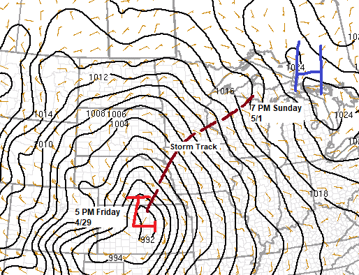
The storm track this weekend would’ve been a good one for a significant winter storm (heavy snow) for much of the Northland, but temperatures are just too warm for precipitation to fall as snow, so instead we’re looking at periods of rain and drizzle through Sunday.
Speaking of snow — 94.2″ of snow has fallen at Duluth for the 2021-2022 season. We only need an additional 5.8″ of snow to hit the 100″ mark, but I think the chances for that to happen are slim to none. Last year’s seasonal snowfall total at Duluth was 76.4″.
What a difference in snowfall totals at International Falls, Minnesota.
Over 50″ more snow this year compared to last year at International Falls!
2021-2022 seasonal snowfall total: 93.5″ (thru April 29th).
2020-2021 season snowfall total: 40.3″ (thru April 29th).
Only 1 day this month with a high of 50 degrees or warmer at Duluth (average in April is 13 days with a high of at least 50). April 2022 will rank 2nd place for fewest number of days with a high of at least 50. The record is zero days set in April 1917.
Three strong low-pressure systems showing up via Goes-16 water vapor loop today.
1: North Atlantic, east of New England.
2: Central/Northern Plains and upper Midwest.
3: West of Washington and Oregon.

Much of northeast Minnesota and northwest Wisconsin is forecast to get up to a half inch of rain this weekend, but some areas will likely get more with totals of 1″+ possible.

- A few showers are possible in northeast Minnesota and northwest Wisconsin tonight.
- A more widespread rain is expected Saturday through Sunday, but some breaks in this rain are likely at times.
- Rain on Saturday will spread from south to north through the day which means that the Borderland and Arrowhead areas will likely remain dry through early Saturday afternoon.
- Will finally see the rain diminish Sunday evening/overnight.
- Patchy fog could also be an issue especially near Lake Superior Saturday through Sunday morning.
Simulated radar forecast through 1 PM Sunday.

A windy weekend ahead especially near Lake Superior including in the Twin Ports.
East to northeast winds gusting 20 to 30 mph tonight through early Saturday morning will increase even more during the day Saturday through Sunday morning with wind gusts of 30 to 45 mph possible. Wind speeds are forecast to diminish Sunday afternoon.
Wind gust forecast through 1 PM Sunday.

Gale force northeast wind gusts are likely over western Lake Superior including the entire North Shore and parts of the South Shore on Saturday.

If you were far enough away from Lake Superior temperatures weren’t bad at all today despite the cloud cover.
Widespread 50s and 60s in eastern Minnesota and in much of Wisconsin this afternoon with 40s and 50s in northeast Minnesota and northwest Wisconsin, with the usual cooler by the lake (temps 35 to 40).
Highs this weekend will be in the 40s to lower 50s in northeast Minnesota and northwest Wisconsin with mid 30s to around 40 for daytime highs closer to Lake Superior.

A classic Central Plains dryline on display today!

Threat for severe thunderstorms, supercells and tornadoes tonight across parts of the Central Plains.

Central Plains dryline shows up nicely on visible satellite imagery as a line of towering cumulus clouds (highlighted in yellow) this afternoon, while wildfires across northern New Mexico are sending plumes of smoke SE into the Texas Panhandle.

Here’s a loop of the above image.

Big time early season heat covering parts of the Central and Southern Plains today with late afternoon temperatures in the 90s!

Ending this post with some good news as we may finally be seeing a bit of shift in the pattern starting next week, but if this actually happens that’s a whole other story considering how stubborn this pattern that we’ve been in has been, but it can’t last forever.
There is a chance that will put together a 5-7 day stretch of dry weather in northeast Minnesota and northwest Wisconsin next week along with more seasonable high temperatures in the 50s and possibly even the 60s! Note: How warm we get near Lake Superior and in Duluth later next week will depend on how the wind direction sets up, so there’s a pretty good chance that temperatures will be cooler near Lake Superior for much of next week as it looks like will have a NE wind on at least a few days next week.

Thanks for reading!
Tim
Leave a Reply