6:32 PM Thursday, April 28, 2022
- Windy and cool weather will continue near Lake Superior through Sunday with milder temperatures inland. Highs mid 30s to low 40s near Lake Superior through Sunday, with highs in the mid 40s to low-mid 50s inland through Saturday, and in the 40s to around 50 Sunday.
- A few showers are possible tonight and Friday.
- Widespread rain likely Saturday and Sunday.
- Two more systems for next week, but currently it looks like both systems will miss us to the south.
An active spring pattern continues with the next large scale system moving ENE across the Rockies today.
Goes-16 water vapor loop from Thursday, April 28, 2022.

Low pressure currently over the southern Rockies this afternoon will move NE through Monday morning with the center of the surface low forecast to pass just west of Marquette, MI early Monday morning.

500mb trough was over the Pacific northwest this afternoon. This trough will dig ESE into the Plains through Friday and then this trough will lift NE through the upper Midwest and western Great Lakes this weekend. As this trough approaches will see better lift move into the area resulting in more widespread rainfall this weekend.

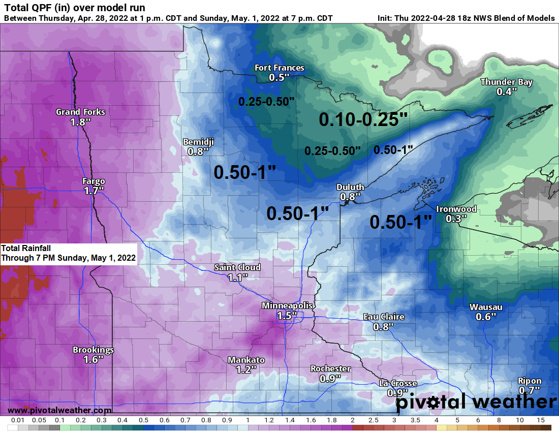
A look at the updated rainfall forecast through Sunday evening.
Greatest amounts of rain ranging from 0.50″ to 1″ are expected from western through southern parts of the Northland, including for the Brainerd Lakes, North Shore and much of northwest Wisconsin.
The Borderland and much of the Iron Range are expected to get anywhere from 0.10″ to 0.50″ of rain this weekend.

There is a marginal risk (at least 5% chance) for rainfall totals to exceed flash flood guidance (green area) from 7 AM Saturday through 7 AM Sunday.

A few showers are possible in parts of the Northland for tonight and Friday, but a more widespread rain is still expected this weekend, with rain spreading from south to north across the Northland during the day Saturday. Rain continues Sunday but the rain is expected to diminish Sunday night.
Simulated radar forecast through 10 PM Sunday.

Strong northeasterly winds will continue near Lake Superior and in the Twin Ports through Sunday. Wind gusts of 25 to 35 mph are likely this evening and again on Friday, with even stronger wind gusts to 40 mph possible from Saturday through early Sunday morning. Wind speeds will finally diminish Sunday afternoon and evening.
Wind gust forecast through 7 PM Sunday.

An active weather pattern continues into next week with at least two more systems showing up per model guidance.
One system early next week (late Monday-Tuesday time frame).

A second system mid to late next week (Wednesday-Thursday).
Note: The storm track with both systems is farther south compared to what we’ve seen in recent weeks, and if this holds up, then much of the Northland will probably stay dry most of next week with better chances for precipitation setting up south of our area. Stay tuned.

Thanks for reading!
Tim
Leave a Reply