5:44 PM Wednesday, April 27, 2022
- Some sunshine is likely again on Thursday, although clouds will be on the increase through the day, so it’s unlikely will see the amount of sunshine that we saw today.
- Generally, overcast skies are then expected from Friday through at least Sunday.
- Scattered rain showers are possible from late Thursday afternoon through the day Friday, and some of these rain showers could mix with snow or sleet across northern Minnesota Thursday night.
- Occasional rain is likely this weekend especially from Saturday afternoon through Sunday.
- Strong northeast winds near Lake Superior through Sunday. Wind gusts of 20 to 30 mph this evening, Thursday and Friday, with even stronger wind gusts expected Saturday and Sunday (30-45 mph).
Forecast rainfall totals this weekend.
Far northern Minnesota (Borderland and Arrowhead) 0.10-0.25″.
Iron Range 0.25-0.50″.
Parts of the North Shore, Twin Ports and north-central Minnesota 0.50-0.75″.
Southern parts of the Northland including the Brainerd Lakes, Hinckley and all of northwest Wisconsin 0.50-1″.

Thursday morning and early afternoon looks mostly dry in northeast Minnesota and northwest Wisconsin, but after that we could see some scattered showers move through parts of the area later Thursday afternoon through Friday.
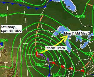
The main system arrives on Saturday with rain spreading from south to north across the Northland during the day, with some rain continuing through Sunday evening before ending late Sunday night/Monday morning the way it looks now.
Not expecting any thunderstorms in our area with this system this weekend, mostly just a light to possibly moderate rainfall. No frozen precipitation either as there isn’t enough cold air from the surface to aloft to support snow or ice.
Simulated radar forecast valid 1 PM Thursday through 7 AM Monday.

Wind gust forecast through 7 PM Sunday.

Temperatures are running about 10 to 15 degrees warmer in most of the Northland this afternoon compared to the last few afternoons, but these temperatures today are still below normal by a good 10 degrees for late April.
The exception to this is near Lake Superior with temperatures in the 30s this afternoon and expect similar temperatures to continue near Lake Superior through Sunday with daytime highs generally in the mid 30s to around 40, but farther away from Lake Superior will see high temperatures in the mid 40s to low 50s through Sunday with a few locations possibly climbing into the mid 50s Friday and Saturday.

Low Temperature Reports from Tuesday morning, April 27, 2022
25 E Ely, MN: 6 F
Crane Lake, MN: 9 F
2 S Brimson, MN: 10 F
Embarrass, MN: 10 F
Grand Marais Airport: 10 F
Ely, MN: 10 F
Orr, MN: 10 F
Seagull Lake, MN: 10 F
Cook, MN: 12 F
Cotton, MN: 14 F
Isabella, MN: 14 F
Barnes, WI: 15 F
Clam Lake, WI: 15 F
Chisholm-Hibbing Airport: 15 F
3 SW Butternut, WI: 16 F
Glidden, WI: 16 F
Aitkin, MN: 16 F
Solon Springs, WI: 16 F
Minong, WI: 16 F
Grand Rapids, MN: 17 F
Siren, WI: 17 F
Ashland, WI: 18 F
Eveleth-Virginia, MN: 18 F
Longville, MN: 18 F
Walker, MN: 18 F
Cass Lake, MN: 19 F
Brainerd, MN: 19 F
Bigfork, MN: 19 F
Hayward, WI: 19 F
International Falls, MN: 19 F
Pine River, MN: 19 F
Two Harbors, MN: 19 F
Moose Lake, MN: 19 F
Washburn, WI: 19 F
Duluth Airport: 23 F
Note: Record cold in the Northland this morning, Tuesday, April 27, 2022.
Hibbing: New record low temperature set for April 27 with a low of 15 degrees. The previous record low for April 27 was 18 degrees set in 2004.
Brainerd: Record low temperature for April 27 tied this morning with a low of 19 degrees. This record was set in 1934 and tied in 2008.
Last week was a cold one across the region with over 300 daily low minimum and low maximum temperature records broken or tied.

After this weekend’s system the next opportunity for getting some precipitation in the Northland will be toward the middle of next week (~May 4-6), but there is a lot of uncertainty in forecast guidance regarding the storm track for next week, but if this system tracks far enough to the north, then we could get some more rain and possibly even some snow in parts of northeast Minnesota and northwest Wisconsin next week. Stay tuned.

Thanks for reading!
Tim
Leave a Reply