5:55 PM Tuesday, April 26, 2022
A Flood Warning is in effect until 1 PM Thursday for a portion of north-central Minnesota including Koochiching County.
Flooding caused by rain and snowmelt is expected.
Flooding of rivers, creeks, streams, and other low lying and flood prone locations is occurring. Numerous roads remain closed due to flooding.
Some locations that will experience flooding include Birchdale, Littlefork, Manitou, Loman, Pelland, Franz Jevne State Park and Indus.
At 1:06 PM Tuesday, a National Weather Service employee reported flooding is occurring near the mouths of the Littlefork and Black Rivers.

Note: Still waiting for the first 60-degree high temperature this year at Duluth, Minnesota, and by the looks of it we’re going to be waiting a while longer!
Here are the top 5 latest dates on record for first 60-degree high temperature at Duluth, Minnesota.
1: May 11 (1950)
2: May 10 (1875)
3: May 9 (1996)
4: May 8 (1893, 1909)
5: May 7 (1917)
The spring of 2022 has been pretty similar to the spring of 2013, and the spring of 1996, so what was the summer like in 2013 and 1996? Let’s take a look!
Two totally different summers
1996 — Colder and wetter than average.
-Average temperature 62.7 F, -1.9 degrees below average. Only 12 days with a high of 80 or warmer (average is 25 days). Warmest temperature 89 on June 28th.
-Total precipitation 16.39″, +4.35″ above average. July 1996 was the 7th wettest July on record with 8.37″ of rain.
2013 — Warmer and drier than average.
-Average temperature 66.2 F, +1.6 degrees above average. 40 days with a high of 80 or warmer, and 6 days with a high of 90 or warmer. Warmest temperature, 94 on July 18th, and August 25th.
-Total precipitation 8.25″, -3.79″ below average.
Average Temperatures/Departure from Average for April 2022 (thru the 25th)
Hibbing, MN: 31.6 F, -4.5 degrees below average
International Falls, MN: 31.8 F, -5.2 degrees below average
Duluth, MN: 33.4 F, -5.1 degrees below average
Ashland, WI: 35.9 F, -2.6 degrees below average
Brainerd, MN: 36.4 F, -4.9 degrees below average
Warmest temperatures so far this month (thru the 25th)
Brainerd: 74 F on the 23rd
Ashland: 64 F on the 23rd
Hibbing: 51 F on the 23rd
Duluth: 50 F on the 9th
International Falls: 50 F on the 9th
Colder than average temperatures (blue and purple) have been the theme across the northern tier of the U.S. this month while parts of the southwest U.S. and southern Plains have had a warmer than average (orange and red) April.

Total Precipitation and Percent of Normal for April 2022 (thru the 25th)
International Falls: 7.11″, 543% of normal
Duluth: 3.52″, 172% of normal
Hibbing: 2.68″, 213% of normal
Ashland: 2.52″, 142% of normal
Brainerd: 1.45″, 116% of normal
Well above average precipitation (blue and purple) from North Dakota to northern Minnesota this month, while it’s been a very dry (red) April across the central Plains.

Record Lows for April 27
International Falls: 12 F set in 1956
Ashland: 15 F set in 1946
Duluth: 18 F set in 1909
Hibbing: 18 F set in 2004
Brainerd: 19 F set in 1934 and 2008
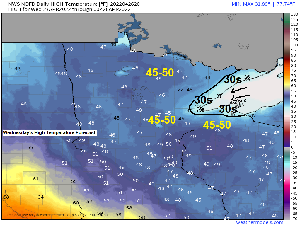
4 PM temperatures ranged from the mid 20s to low 30s in northeast Minnesota and northwest Wisconsin, just another spring day that is well below average in our area when it comes to the temperatures.

Clouds lingered over the Northland today, but sunshine should become more abundant on Wednesday, in fact Wednesday is looking like our sunniest day of the week.

Three more systems lined up through the middle of next week.
1: A weaker system Thursday which could bring some light rain or a mix of rain, sleet and snow to northeast Minnesota and northwest Wisconsin.
2: A more organized and stronger system also a slow moving one lifts NE out of Nebraska this weekend. Rain is likely in much of the Northland as this system moves through the area from Saturday afternoon through Sunday night. Gusty northeast winds are also likely near Lake Superior this weekend with wind gusts 25-30+ mph expected.
3: Another system could hit the Northland the middle of next week ~May 3-5, this one if it hits us could bring some snow or rain to the Northland the middle of next week.
Here’s a look at Thursday’s system which could bring some rain or a mixture of rain, snow and sleet to the Northland especially Thursday afternoon/evening the way it looks now.
Simulated radar forecast valid 7 AM Thursday to Midnight.

Weekend system.

Rainfall amounts of a quarter to half inch are possible south of Highway 2 in northeast Minnesota and in much of northwest Wisconsin this weekend with lesser amounts of rain farther north including for the Arrowhead and Borderland areas.
Higher rainfall amounts approaching an inch are possible around the Brainerd Lakes to Hinckley this weekend.

Here’s an early look at the system for the middle of next week which could impact the Northland.

Thanks for reading!
Tim
Leave a Reply