5:41 PM Monday, April 25, 2022
- Although will have some dry days mixed in, the overall trend looking out for about the next two weeks (through May 10th) is for above average precipitation in much of northeast Minnesota and all of northwest Wisconsin.
- A few snow showers and flurries tonight.
- Some rain possible Thursday.
- A more organized system could bring some more rain to the Northland this weekend (April 30-May 1).
- More low-pressure systems lined up for next week.

With temperatures as cold as they were today, they won’t have to drop much tonight to reach record cold territory Tuesday morning.
Note: Marquette, MI had a high of 73 on Sunday, fast forward to this afternoon 32 with light snow!

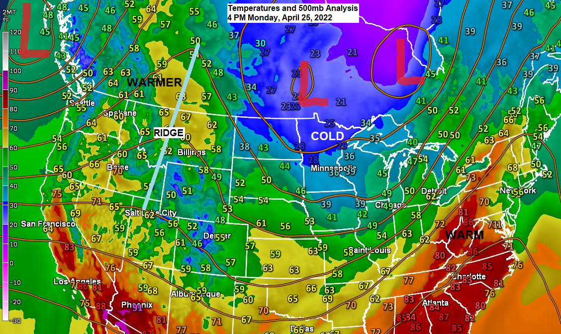
Temperatures are running 15 to 30 degrees colder than average across the Northern Plains and upper Midwest late this afternoon.
Warmer east and west, cold bubble in between!

Lows tonight are forecast to range from the mid-teens to mid 20s in northeast Minnesota and northwest Wisconsin with record or near record cold possible Tuesday morning.
Here are the record low temperatures for April 26.
International Falls, MN: 14 F set in 1996 and 1959
Brainerd, MN: 15 F set in 1950
Hibbing, MN: 16 F set in 2002
Ashland, WI: 17 F set in 1919
Duluth, MN: 20 F set in 1996 and 1950

Snow showers and flurries are likely in parts of the Northland tonight through Tuesday morning with some lake effect snow along the South Shore of Lake Superior from the Bayfield Peninsula to the Hurley and Gile areas in northern Wisconsin.
Simulated radar forecast through 9 AM Tuesday.

Up to 2 inches of snow is possible along the South Shore of Lake Superior in northern Wisconsin with mostly a trace to less than an inch of snow for northeast Minnesota through Tuesday afternoon.

One upper level low (remnants of this past weekend’s system) continues to move northeast toward southern Hudson Bay Canada this afternoon, but another upper low currently along the Manitoba-Ontario border will move SE across the Northland late tonight before exiting off to the east Tuesday afternoon.
Goes-16 water vapor loop from Monday, April 25, 2022.

There is some uncertainty in the computer models on the track of this weekend’s system and how far north the precipitation will spread, but this is looking like a slow-moving system once again, but it also looks to weaken a bit by the time it reaches the upper Midwest.
East winds north of this late week/weekend system will keep temperatures on the cool side (highs mid 30s to low 40s) near Lake Superior and in the Twin Ports Friday through Sunday, while farther inland daytime highs look to be in the mid 40s to mid 50s Friday through Sunday.

Currently it looks like much of the Northland will get some rain from Saturday afternoon through early Monday morning with the highest rain amounts setting up mostly south of Highway 2 in northeast Minnesota into far northwest Wisconsin (0.50″+)
Rain totals farther north including for the Arrowhead and Borderland look to be in that 0.10-0.25″ range.

Below average temperature trends continue for northeast Minnesota and northwest Wisconsin into early May.
Below average temps (blue and green)
Above average temps (orange and red)

Below average temps (blue and green)
Above average temps (orange and red)

Thanks for reading!
Tim
Leave a Reply