6:18 PM Sunday, April 24, 2022
The active pattern we’ve been in shows no signs of going away.
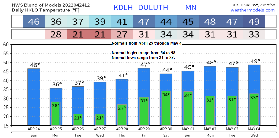
- Blustery and turning colder the next few days.
- Record cold is possible in the Northland Monday night/Tuesday morning.
- A few rain showers tonight changing to flurries and snow showers Monday-early Tuesday.
- A widespread precipitation event is possible in the April 29-May 1 time frame, with a minor precipitation event possible on April 28.
Best chance for seeing quite a bit of sunshine this week comes on Wednesday, but that’s not to say that we won’t see at least a little sun before then because we likely will on Monday and again on Tuesday, so enjoy those 5 or maybe 10 minutes of sunshine.
RECORD OR NEAR RECORD COLD IS POSSIBLE MONDAY NIGHT/TUESDAY MORNING.
Record Low Temperatures for April 26
International Falls: 14 F set in 1996 and 1959
Brainerd: 15 F set in 1950
Hibbing: 16 F set in 2002
Ashland: 17 F set in 1919
Duluth: 20 F set in 1996 and 1950
Comparing the Spring of 2022 to the Spring of 2013 at Duluth.
Spring 2022: 2 days with a high of 50 or warmer (thru April 24).
Spring 2013: 1 day with a high of 50 or warmer (thru April 24).
Spring 2022: First 60 degree high (still waiting for it).
Spring 2013: First 60 degree high came on April 26. Note: We ended April 2013 with 5 days in a row with highs in the 60s (April 26-30), that’s unlikely to happen this April.
May 2013: First 80 came on May 15, and we had 8 days with a high of 70 or warmer, average is 8 days (1991-2020 climate period).
Some notable late dates for first 60-degree high temperature at Duluth, Minnesota.
Note: Record latest first 60 is May 11 (set in 1950)
1996: May 9
2013: April 26
April 2022 has been very wet from the Northern Plains to the upper Midwest with several climate districts reporting their wettest April on record, or a top 10 wettest April on record (darker green areas).

It’s been a wet spring across the Northern Plains, upper Midwest to the Great Lakes with several climate districts reporting their wettest spring on record, or a top 10 wettest spring on record thus far (darker green areas).
Meanwhile farther south the Spring of 2022 has been a dry one thus far, especially from southern South Dakota into parts of Nebraska (brown areas).

Not much of a surprise here.
April 2022 is running well below average in the temperature department in the darker blue areas with a top 10 coldest April on record by climate district stretching from Montana to the Dakotas into much of Minnesota, and even as far south as Iowa.

Much of the area saw a dramatic cool down today compared to Saturday, but areas closer to Lake Superior are seeing warmer temperatures today compared to Saturday, and this all has to do with the wind direction. Strong NE wind on Saturday kept highs in the 35-to-40-degree range near Lake Superior, but a wind shift to the SSW today has led to temperatures climbing to around 46-49 degrees near Lake Superior this afternoon.
The power of Lake Superior and the microclimate near the lake is always amazing.

A strong spring storm continues to affect the Northland today as low pressure from the surface to aloft makes its way northeast into southern Ontario.
Moisture wrapping around this system brought another day of mostly cloudy skies to the Northland with scattered rain showers too.
Goes-16 visible satellite loop from Sunday, April 24, 2022.

A look at the latest spring storm to hit the upper Midwest via Goes-16 water vapor loop from Sunday, April 24, 2022.

Even in lake effect snow country AKA Marquette, MI the temperature climbed into the 70s today with a high of 73!
6 PM temperatures range from 28 Devils Lake, ND to 81 at Detroit, MI.

Rainfall Totals from April 22-24, 2022 (thru 4 PM on the 24th).
International Falls, MN: 4.03″
Hibbing, MN: 0.87″
Duluth, MN (Airport) 0.71″
Brainerd, MN: 0.31″
Ashland, WI: 0.13″

Significant river flooding is occurring in red, likely in orange, and possible in yellow.

The next system to keep an eye on will be the one moving into the Pacific northwest around midweek. This system may impact the Northland late this week or in the April 29-May 1 time frame.
500mb forecast valid April 28 through May 2, 2022.
Troughs/unsettled weather in blue and green.
Ridges/generally quiet weather in orange.

Although temperatures remain on the cool side with this possible storm later this week, it doesn’t look cold enough (at the moment) for there to be much snow in northeast Minnesota and northwest Wisconsin, with rain being the main precipitation type, but things could change over the next few days.

Thanks for reading!
Tim
Leave a Reply