6:36 PM Wednesday, May 11, 2022
A few more rounds of showers and thunderstorms are likely through Thursday night.
TONIGHT – The threat for severe thunderstorms is highest across far southern parts of the Northland including parts of east-central Minnesota into parts of northwest Wisconsin. The primary threats with tonight’s storms would be from large hail of quarter size to ping pong ball size (1″-1.5″ diameter) with damaging wind gusts also possible.

HRRR model simulated radar forecast through 7 AM Friday.

Ingredients favorable for tornado genesis are in place across southern Minnesota late this afternoon, and that area has the best chance for a few tornadoes through early this evening.

Round after round of storms forming on the north side of an intense heat dome centered over the Midwest today.
Goes-16 infrared (sandwich) satellite loop from Wednesday, May 11, 2022.

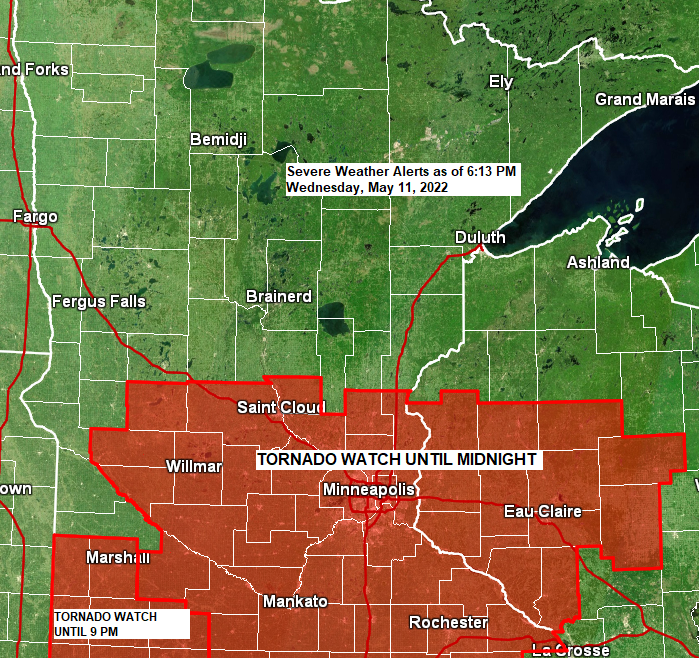
Radar loop ending 6 PM Wednesday, May 11, 2022.

Warm front has a long way to go before moving into the Northland and with thunderstorms continuing to develop near this boundary today this has slowed the northward advancement of the warm frontal boundary.
It remains to be seen just how far north this warm front will get on Thursday. If we see rounds of convection continue to develop near this boundary, then I doubt this warm front makes it much farther north than the I94 corridor in central Minnesota Thursday afternoon.

Here’s the setup for Thursday and where I think the greatest chances are for a few tornadoes late Thursday afternoon/evening.

THURSDAY – Scattered to numerous strong to severe thunderstorms are expected in the Northland Thursday into Thursday night with the highest chance for severe storms covering the southwest part of the Northland (orange area on map) from around Walker and Brainerd east to Aitkin, Hinckley, and Pine City. The primary threats with Thursday’s storms will be from large hail of quarter size to ping pong ball size (1″-1.5″ diameter) along with damaging wind gusts. There is also a chance for an isolated tornado late Thursday afternoon/early evening around the Brainerd Lakes area but that will depend on timing of the storms and how far north the warm front gets during the day Thursday.


HEAVY RAIN/FLOOD POTENTIAL
There is a lot of moisture in the air this afternoon with PWAT values >1.50″ over southwest Minnesota with values >1.25″ as far north as Duluth. With all of this deep moisture already in place this increases the potential for areas of heavy rain in parts of the Northland tonight.

Heavy rain may lead to flash flooding tonight especially in the yellow area on the map where there is at least a 15% chance for rainfall to exceed flash flood guidance with lower chances farther north (green area).

The highest risk for heavy rain and flash flooding (yellow area) shifts farther north into northern Minnesota on Thursday with a lower risk (green area) for rainfall amounts to exceed flash flood guidance farther south including for parts of northeast and east-central Minnesota and all of northwest Wisconsin.

RAINY LAKE/RAINY RIVER BASIN FLOODING

A mid-summer type pattern in place right now with a massive upper-level ridge with 500mb heights approaching 592 decameters covering the Midwest while a strong and deep upper-level trough covers the western U.S.
Will see this pattern slowly break down over the next few days.

Thanks for reading!
Tim
Leave a Reply