6:00 PM Thursday, May 19, 2022
Scattered showers and a few thunderstorms are likely in the Northland tonight with the greatest chances for thunderstorms setting up over eastern Minnesota into much of northwest Wisconsin.
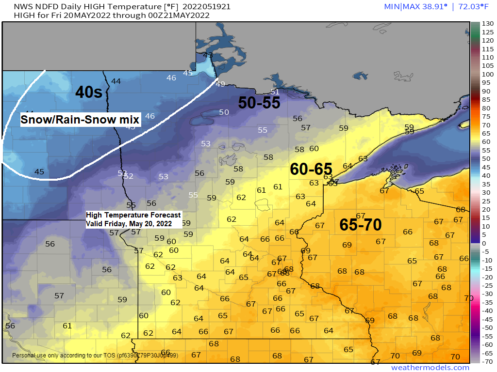
Friday is shaping up to be a pretty nice late spring day in the Northland with at least some partial sunshine expected. A breezy southwest wind is likely on Friday with highs in the 60s. There is a chance for isolated showers during the afternoon-early evening but most of us should stay dry.
A much cooler air mass moves in Friday night and lingers through this weekend with a chance for patchy frost Friday night and again Saturday night. A few rain showers are also possible this weekend, and temperatures may become cold enough to where we see some snow mix in with these rain showers especially over northern Minnesota early Saturday morning.
Isolated strong to severe thunderstorms are possible through late this evening in eastern Minnesota and northwest Wisconsin. The primary severe weather threats for those areas will be from large hail to 1 inch in diameter (quarter size) and damaging wind gusts to 60 mph.

The greatest threat for severe thunderstorms this evening is over southern to eastern Minnesota into west-central and southwest Wisconsin where a Tornado Watch (red) and Severe Thunderstorm Watch (yellow) is in effect.

We’ve already seen one round of elevated supercell thunderstorms roll through the Twin Cities metro area late this afternoon with numerous reports of large hail ranging from 1″ to 2″ diameter, or from quarter size to lime size!

Simulated radar forecast through 7 PM Friday.
Rain (green)
Snow (blue)
Note: Some snow or a rain/snow mix is likely in northeast North Dakota into northwest Minnesota Friday afternoon/evening.

Rainfall totals ranging from 0.05 to 0.30″ are expected in northeast Minnesota and northwest Wisconsin tonight with a chance for higher rainfall amounts with thunderstorms.

FLOOD WARNING UPDATE
-Flood Warning extended until early Tuesday afternoon for the Mississippi River at Fort Ripley. Minor flooding is expected.
-Flood Warning continues until further notice for the Mississippi River at Aitkin with moderate flooding occurring.
-Flood Warning continues until Noon Friday for a portion of northeast Minnesota including St. Louis County. Some locations that will experience flooding include Island Lake, Fredenberg, Taft and Fish Lake. Water has begun to recede from the crest as Minnesota Power’s plan is to decrease output from Island Lake by 100 cfs per hour until outflow matches inflow. Flooding will continue until output reaches 3500 cfs from the Island Lake Dam.


A major winter storm is on the way for parts of the Rockies Friday and Saturday with winter storm warnings in effect including for the Denver area where temperatures were in the mid to upper 80s today!

Simulated radar forecast zoomed in on Colorado showing the snow (blue) that is forecast to fall beginning late tonight, with snow through Friday, Friday night and Saturday morning with snow tapering off Saturday afternoon.

Snowfall forecast

A major early season heat wave continues across the central and southern U.S. while a strong trough digs SE into the Northern Rockies today. A potent jet stream separates the intense heat to the south and cooler temperatures to the north with storm clusters forming north of the intense heat across parts of the Midwest and upper Midwest today.
Water vapor loop from Thursday, May 19, 2022.

These temperatures would be impressive in June considering how widespread the 90 and 100+ degree temperatures are today, but for it only being mid-May this is very impressive!
Note: At 4 PM today, it was 106 degrees at Childress, TX, meanwhile at Casper, WY it was snowing and 33 degrees!

***ADDITIONAL STORM REPORTS FROM WEDNESDAY, MAY 18, 2022***
6:50 PM: Thunderstorm Wind Damage. 9 NNE Mercer, WI (Iron County) Part of a roof ripped off a house, and a part of a wall blown down attached to a screen porch. Approximately 10 trees down as large as a foot and a half to two feet in diameter. Large pine tree snapped. Dime sized hail also reported.
6:30 PM: Thunderstorm Wind Damage. 5 NNW Springstead, WI (Iron County) Numerous large trees down across roads, cracked near the base, and uprooted.
6:22 PM: Thunderstorm Wind Damage. 2 E Butternut, WI (Ashland County) Half of a maple tree was damaged with some 2 foot diameter branches broken off.
5:45 PM: Thunderstorm Wind Damage. 3 SSW Washburn, WI (Bayfield County) Very large spruce tree split near base and landed on house, causing roof damage.
5:44 PM: Thunderstorm Wind Damage. 4 E Odanah, WI (Ashland County) Downed trees and power lines.
4:16 PM: Thunderstorm Wind Damage. 3 NNE Rice Lake, MN (St. Louis County) Numerous large pine trees down.
4:12 PM: Thunderstorm Wind Damage. 4 ESE Twig, MN (St. Louis County) Large tree down and fallen across upper balcony porch of a house along Pike Lake.
4:12 PM: Thunderstorm Wind Damage. 4 ESE Twig, MN (St. Louis County) Large tree half snapped off near the base and half uprooted.
4:06 PM: Thunderstorm Wind Damage. 1 S Kettle River, MN (Carlton County) Trees of four, five, and eight inches in diameter blown over Highway 73 south of Kettle River.
4:06 PM: Thunderstorm Wind Damage. Twig, MN (St. Louis County) Healthy spruce tree with additional deciduous tree branches on the ground around it.
4:00 PM: Thunderstorm Wind Damage. 1 SSW Saginaw, MN (St. Louis County) A few trees snapped, estimated 14 to 16 inches round, or about 5 to 6 inches diameter.
3:57 PM: Thunderstorm Wind Damage. 3 WSW Saginaw, MN (St. Louis County) Numerous large trees with an estimated diameter of over 1 foot down or bent over. Some trees were uprooted and others were snapped near the base.
3:55 PM: Thunderstorm Wind Damage. 1 SSW Saginaw, MN (St. Louis County) Large pine tree uprooted.
3:55 PM: Thunderstorm Wind Damage. 1 S Payne, MN (St. Louis County) Tree damage and power outages were reported in the eastern part of Meadowland Township.
3:49 PM: Thunderstorm Wind Damage. 1 SSW Brookston, MN (St. Louis County) Childrens playhouse swingset fort blown over and tossed about the yard.
3:47 PM: Thunderstorm Wind Damage. 1 WNW Saginaw, MN (St. Louis County) Numerous trees and power lines down across roads.
3:05 PM: Thunderstorm Wind Damage. 3 E Crosslake, MN (Crow Wing County) Three sections of dock were blown into Goodrich Lake by the wind.
2:35 PM: Thunderstorm Wind Damage. 12 N Grand Rapids, MN (Itasca County) Reports of several trees down around 4 to 5 inches in diameter. Powerlines were also down due to trees falling on them.
Quite a severe weather event in the Northland Wednesday afternoon.
Zoomed in view on Duluth showing the storm reports from Wednesday.

And a zoomed-out view of the numerous severe weather reports from Wednesday, May 18, 2022.

Thanks for reading!
Tim
Leave a Reply