7:54 PM Sunday, May 22, 2022
-Another chilly night ahead with areas of frost likely across the entire Northland.
-Pleasant late spring weather Monday and Tuesday with warmer temperatures! Highs on Monday in the low to mid 60s, highs on Tuesday in the mid 60s to around 70.
-Rain chances return Wednesday with much cooler temperatures especially near Lake Superior and for inland areas of northwest Wisconsin.
Frost Advisory in effect from 11 PM tonight to 8 AM Monday for all of northeast Minnesota and northwest Wisconsin including the cities of International Falls, Bigfork, Grand Rapids, Walker, Brainerd, Aitkin, Hill City, Pine City, Hinckley, Moose Lake, Cloquet, Duluth, Hibbing, Ely, Cook, Crane Lake, Two Harbors, Isabella, Silver Bay, Grand Marais, Superior, Solon Springs, Washburn, Bayfield, Ashland, Hurley, Siren, Spooner, Shell Lake, Hayward and Winter. Temperatures as low as 31 to 33 degrees will result in frost formation.
*Updated Flood Information*
-Flood Warning continues until further notice for the Mississippi River at Aitkin with minor flooding occurring. At 1:30 PM Sunday the stage was 14.9 feet. Flood stage is 13.0 feet. The river is expected to lower but stay above flood stage until further notice.
-Flood Warning in effect until Monday evening, May 23rd for the Mississippi River at Fort Ripley. At 1:30 PM Sunday the stage was 10.5 feet. Flood stage is 10.5 feet. The river is expected to fall below flood stage by tomorrow morning and continue falling to 9.7 feet by Sunday morning, May 29th.
-Flood Warning in effect until 5 PM Wednesday for portions of north-central and northeast Minnesota including the counties of Koochiching, St. Louis and Lake. Areas affected include Rainier, Island View, Voyageurs National Park, Crane Lake, Kabetogama Lake and Lake Vermilion. Lake level rises are ongoing. Flooding continues on area lakes and rivers. Widespread impacts are ongoing for shoreline residents. Lake inflows are slowing for Crane Lake, Kabetogama Lake and Namakan Lake, however, inflows still exceed outflows so rises will continue especially on Rainy Lake.

The number of above average and below average days have pretty equal so far this month at Duluth, with 50% of days this month being warmer than average, and 45% of days being below average.
Above average: 11 days (red)
Below average: 10 days (blue)

Average monthly temperatures for May 2022 (thru the 21st) are running about 1 to 2 degrees warmer than average in northeast Minnesota and northwest Wisconsin – See below.
Brainerd: 56.0 F, +2.5 degrees above average
Duluth: 51.7 F, +1.4 degrees above average
Ashland: 51.5 F, +1.7 degrees above average
International Falls: 50.2 F, +1.1 degrees above average
Hibbing: 49.0 F, +1.2 degrees above average
Note: Duluth has had 5 days so far in May 2022 with a temperature of 70 or warmer. The average number of days with a temperature of 70 or warmer in May is 8 days (1991-2020 climate period).

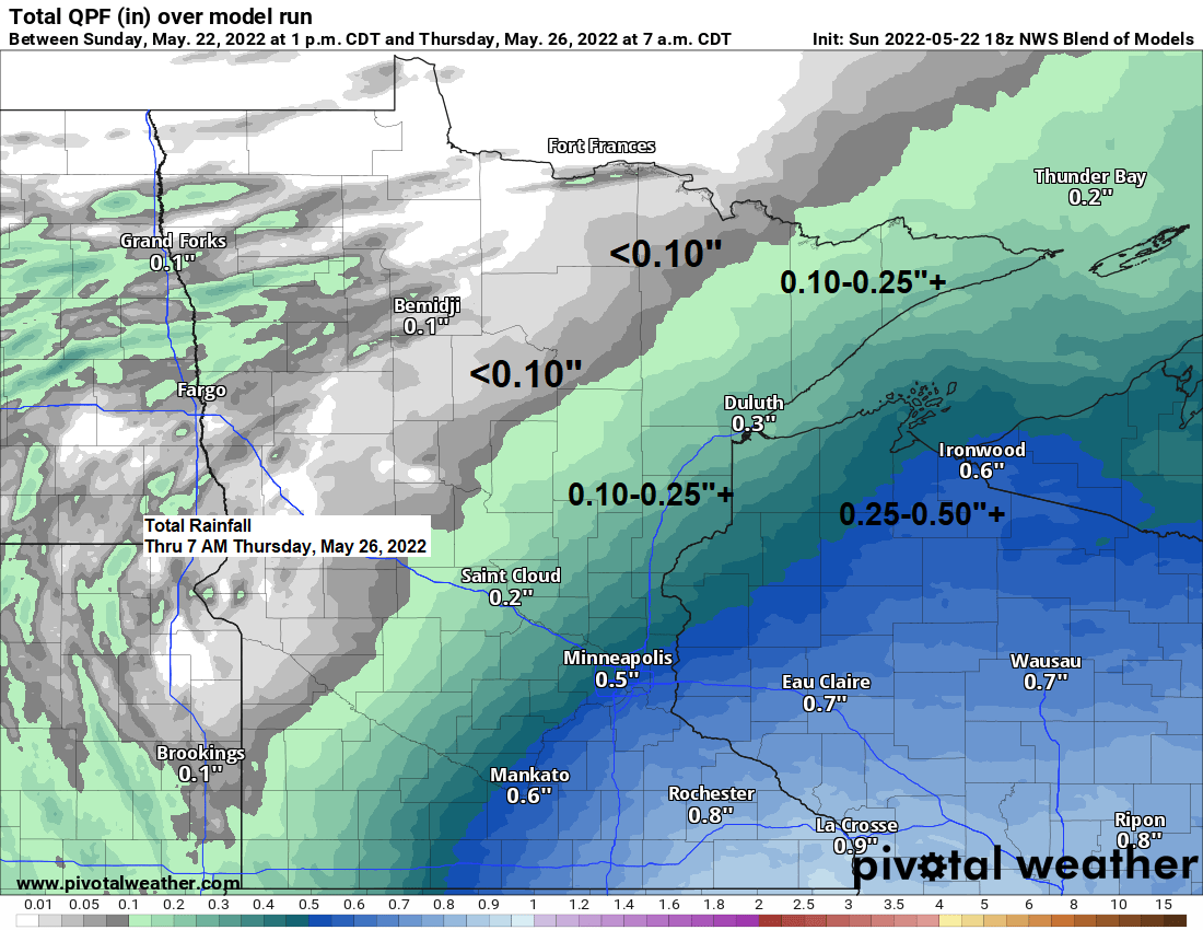
A system moving in the middle of the week may be the start of another period of active weather in the Northland.
Low pressure over northern Missouri Wednesday morning is forecast to lift N/NE reaching northern Lake Michigan Thursday morning. With the low tracking pretty far to the SE that leaves our area on the NW or cooler side of this system which reduces the threat for thunderstorms and heavy rain, but widespread mostly light to possibly moderate rain is expected in all of northwest Wisconsin, and also from eastern into northeast Minnesota. Timing of this rain looks to be from Wednesday afternoon through Thursday morning, with the rain spreading from south to north during the day Wednesday.
Note: Currently it looks like northern Minnesota will miss out on getting much rain with this system for midweek, and this would include the Rainy Lake area where flooding continues.
Gusty NE winds are also possible near Lake Superior on Wednesday with a chance for some gale force winds on western Lake Superior.

It does appear that the Northland will be getting back into an active weather pattern from time to time over the next two weeks with 2 or more inches of rain possible in all of northeast Minnesota and northwest Wisconsin.


Thanks for reading!
Tim
Leave a Reply