5:53 PM Thursday, May 26, 2022
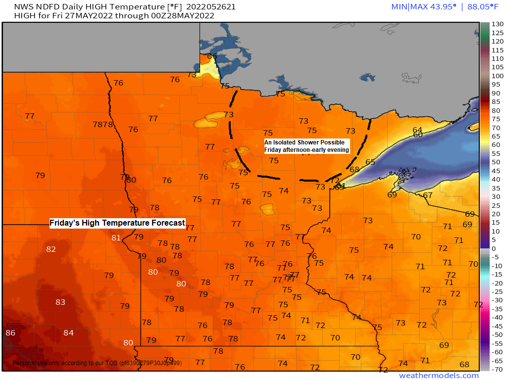
- Very pleasant weather is expected on Friday with quite a bit of sunshine and mild temperatures.
- Several rounds of scattered showers and thunderstorms are expected from Saturday morning through next Tuesday.
- There is a potential for a few strong to severe thunderstorms in parts of the Northland Sunday and Memorial Day.
- Heavy rain is also possible at times this weekend into early next week which may lead to flooding in areas that see multiple rounds of storms thru early next week.
- High temperatures Saturday through Monday will be in the 60s and 70s in the Northland, but temperatures could be as warm as the 80s Sunday and Monday if there is less rain and more sun. Temperatures will likely be cooler near Lake Superior Saturday through Monday.
The threat for strong to severe thunderstorms in the Northland is on the low side for Saturday, May 28th.

The threat for strong to severe thunderstorms increases Sunday/Sunday night with the highest chances further to the southwest (red).

A risk for a few strong to severe thunderstorms continues on Memorial Day for southern parts of the Northland including east-central Minnesota and far northwest Wisconsin (yellow).

Although much of the Northland is expected to stay dry on Friday there is a chance for a few isolated showers mostly over northern Minnesota Friday afternoon/evening.
A more organized area of rain showers could affect parts of the Northland Saturday morning into early Saturday afternoon, and this precipitation will be driven by warm and moist advection near a warm front stretching from central North Dakota to southern Minnesota. Instability looks pretty limited with this round of precipitation Saturday morning, so the threat for thunderstorms is on the low side.
Simulated radar forecast valid 7 AM Friday to 7 PM Saturday.

A ridge developing to the east and a trough out west will cause a SW flow aloft to develop over the Plains and upper Midwest while southerly winds transport deeper low-level moisture northward out of the Gulf. This pattern is favorable for multiple rounds of showers and thunderstorms west and north of the ridge, thus above average rainfall is expected thru the middle of next week from the Northern Plains to upper Midwest.

Ensemble models are in good agreement on rainfall amounts thru the middle of next week with widespread 1-2″+ totals.


A well-developed low-pressure system continues to move slowly east across southern Missouri and northern Arkansas this afternoon with plenty of clouds behind this system stretching from eastern Minnesota to eastern Oklahoma with widespread sunshine farther west this afternoon.
Goes-16 visible satellite loop from Thursday, May 26, 2022.

A pocket of much cooler temperatures has moved a little farther east compared to where it was 24 hours. And this aforementioned bubble of cool air stretched from eastern Kansas, northern Arkansas and Missouri north into the upper Midwest today.

Temperatures late this afternoon are running anywhere from 15 to 20 degrees colder than normal on this 26th day of May from much of eastern Oklahoma and Arkansas, north to eastern Minnesota and Wisconsin.

Rainfall Analysis for Wednesday, May 25, 2022.

Thanks for reading!
Tim
Leave a Reply