5:31 PM Wednesday, May 25, 2022
- Rain in parts of northeast and far eastern Minnesota and all of northwest Wisconsin will gradually end tonight.
- Gusty NE winds (20-35 mph) continue near Lake Superior this evening.
- Nicer weather returns Thursday but more so on Friday with widespread 70s for daytime highs expected on Friday.
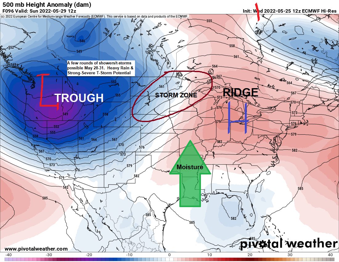
- Humidity builds this weekend into early next week with rounds of scattered showers and thunderstorms possible.
- Potential for heavy rain and a few strong to severe thunderstorms for parts of the Northland this weekend into early next week.
- High temperatures Saturday through Memorial Day could warm well into the 70s and 80s in much of the Northland, but if rain is more persistent and cloud cover more extensive, then temperatures will end up quite a bit cooler (60s to around 70).
Rainfall Reports thru 4 PM Wednesday, May 25, 2022
Hayward, WI: 0.70″
Glidden, WI: 0.64″
Clam Lake, WI: 0.63″
Ashland, WI: 0.59″
Washburn, WI: 0.58″
Barnes, WI: 0.52″
Solon Springs, WI: 0.42″
Minong, WI: 0.42″
Siren, WI: 0.39″
Hinckley, MN: 0.30″
Duluth, MN (Airport) 0.25″
Duluth Sky Harbor Airport: 0.23″
Two Harbors, MN: 0.21″
Moose Lake, MN: 0.21″
Saginaw, MN: 0.19″
Superior Airport: 0.19″
Grand Marais, The Bay of Grand Marais, MN: 0.19″
Cloquet, MN: 0.17″
Isabella, MN: 0.15″
Grand Marais Airport: 0.06″
McGregor, MN: 0.03″
Aitkin, MN: 0.03″
Eveleth-Virginia, MN: 0.02″
Chisholm-Hibbing Airport: 0.01″
Brainerd, MN: 0.01″
Rain continues in parts of northwest Wisconsin and near Lake Superior in northeastern Minnesota late this afternoon. This rain will diminish from SW-NE this evening.
Radar loop ending 5:10 PM Wednesday, May 25, 2022.

A northern stream trough (black) with some influence from a southern stream trough (red) helped to bring some rain to parts of the Northland today.

This system won’t fully phase, however, as the trough over the Southern/Central Plains moves almost due east instead of turning north/northeast. What this means for the Northland is for drier weather to return on Thursday.
500mb height anomaly forecast thru 7 AM Friday, May 27, 2022.

It’s a chilly late May day across much of the Northland with temperatures this afternoon only in the 40s to around 50 with much warmer temperatures in the 70s farther west over parts of the Dakotas this afternoon, these warmer temperatures will be moving into the Northland on Friday.

A pocket of cool air due to widespread clouds and rain stretches from Oklahoma to the upper Midwest today with much warmer temperatures surrounding this cool pocket.

Temperatures are running 15 to around 30 degrees below normal from Texas to Minnesota, east to Wisconsin and Michigan today.

***Flood Update***
-Flood Warning continues until further notice for the Mississippi River at Aitkin with minor flooding occurring. At 8:30 AM Wednesday the stage was 14.2 feet. Flood stage is 13.0 feet. The river is expected to fall below flood stage early Sunday morning and continue falling to 12.0 feet Wednesday morning, June 1st.
-Flood Warning remains in effect until 4 PM Monday, May 30th, 2022, for rivers and lakes within the Rainy River Basin including Crane Lake, Namakan Lake, Kabetogama Lake and Rainy Lake. Namakan Lake has already surpassed the level reached in the 2014 flood and is continuing to rise. Rainy Lake rose above the 2014 level May 23rd. Strong lake level rises are ongoing. Flooding continues and lake levels have yet to crest. Expect high water continuing for the next several weeks. Some locations that will experience flooding include Rainier, Island View, Voyageurs National Park, Crane Lake and Kabetogama Lake.
5-Day Significant River Flood Outlook thru May 30, 2022
Significant River Flooding is occurring in red.

Heads up for Sunday as there is a chance for a few strong to severe thunderstorms in southern parts of the Northland including the Brainerd Lakes, Grand Rapids, Twin Ports, Hayward and Hinckley areas.

Thanks for reading!
Tim
Leave a Reply