1:14 PM Monday, May 30, 2022
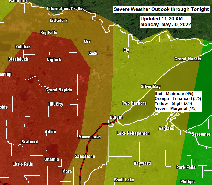
Widespread severe thunderstorms are expected in much of north-central Minnesota late this afternoon into this evening, with scattered to numerous severe thunderstorms expected in much of northeast into far eastern Minnesota with scattered severe thunderstorms in much of northwest Wisconsin.
In addition to the potential for some tornadoes in north-central Minnesota late today, there is also a significant risk from damaging wind gusts of 60 to 80 mph, and large hail to 2″ in diameter across much of the Northland.
Timing of all this is from late this afternoon through late this evening, or roughly from around 4 PM to 1 AM — earliest in west/southwest parts of the Northland, then spreading farther north/east through the evening.


Here’s a look at the Updraft Helicity tracks through late this evening.
This parameter is used to determine where we may see rotating supercell thunderstorms which increases the potential for large hail and tornadoes.
Brighter colors indicate a higher likelihood for rotating storms.
Notice how the brighter colors are mostly over central and northern Minnesota with more dull colors farther to the east, this indicates the greatest threat for rotating storms would be over central and northern Minnesota if these two computer model forecasts verify.


Simulated radar forecast through 1 AM tonight.

It might be a good idea to know the county you live in, and also what part of the county you live in, just in case your part of the county is in some sort of severe thunderstorm, tornado, flood watch or warning.

A very powerful mid-upper-level trough ejecting N-NE out of the Rockies as seen on water vapor imagery Monday, May 30, 2022.

Here’s the basic setup in what is behind this potential severe weather event through tonight.
At least two warm fronts and two areas of low pressure, although the main low is the one over northeast Nebraska early this afternoon, and that low will continue to lift N-NE through tonight. This is a very deep system for late May with a central pressure of the Nebraska low sitting at 990mb as of Noon today.

Lots of moisture streaming north on southerly winds ahead of this system today while dry air punches in from the SW.

Strong moisture transport (greens and pink) aimed right at the upper Midwest early this afternoon.

A negatively tilted trough ejecting NE out of the Rockies this afternoon with very strong winds aloft blasting NE out of the Central Plains.

Strong mid-level winds also in place ahead of the aforementioned trough today.

A Flood Watch (green) remains in effect through Tuesday morning — Some cities included in the flood watch are International Falls, Pine River, Ely, Brainerd, Hill City, Grand Rapids, Walker, Bigfork, and Hibbing.
Flash flooding caused by excessive rainfall continues to be possible with several more rounds of thunderstorms expected through tonight.

Radar rainfall estimates from the early day storms which affected a large portion of the Northland.

A zoomed in view on the Grand Rapids and Hibbing areas which saw very heavy rainfall amounts this morning.

24-Hour Rainfall Reports ending 12 PM Monday, May 30, 2022
International Falls, MN: 1.96″
Chisholm-Hibbing Airport: 1.96″
Grand Rapids, MN: 1.86″
Bigfork, MN: 1.46″
Littlefork, MN: 1.07″
Seagull Lake, MN: 0.94″
Hill City, MN: 0.80″
Orr, MN: 0.72″
Isabella, MN: 0.69″
Eveleth-Virginia, MN: 0.60″
Moose Lake, MN: 0.58″
Saginaw, MN: 0.55″
Longville, MN: 0.53″
Brainerd, MN: 0.53″
Cass Lake, MN: 0.47″
Pine River, MN: 0.47″
Cloquet, MN: 0.47″
Ely, MN: 0.44″
Grand Marais, The Bay of Grand Marais: 0.44″
McGregor, MN: 0.39″
Duluth Airport: 0.30″
Siren, WI: 0.20″
Minong, WI: 0.19″
Two Harbors, MN: 0.10″
Washburn, WI: 0.09″
Grand Marais Airport: 0.08″
Hayward, WI: 0.06″
Solon Springs, WI: 0.05″
Duluth Sky Harbor Airport: 0.02″
Superior Airport: 0.02″
Local Storm Reports from May 30, 2022
7:30 AM: Flood — Keewatin, MN (Itasca County)
7:30 AM: Hail 1.00″ (quarter size) 2 ENE Hovland, MN (Cook County)
5:26 AM: Thunderstorm Wind Damage. 5 NE Brainerd, MN (Crow Wing County) A white pine tree snapped near the base of the trunk.
5:15 AM: Thunderstorm Wind Damage. 8 SE Brainerd, MN (Crow Wing County) Oak tree blown over near South Long Lake.
5:05 AM: Hail 1.25″ (half dollar size) 2 NE Munger, MN (St. Louis County)
5:00 AM: Hail 1.00″ (quarter size) 4 ESE Twig, MN (St. Louis County)
4:59 AM: Hail 1.00″ (quarter size) 4 NNE Munger, MN (St. Louis County)
4:47 AM: Hail 1.00″ (quarter size) Cloquet, MN (Carlton County)
4:40 AM: Hail 1.00″ (quarter size) 5 NE Mahtowa, MN (Carlton County)
4:24 AM: Hail 1.25″ (half dollar size) 2 SW Barnum, MN (Carlton County)
4:23 AM: Hail 1.00″ (quarter size) 1 NNE Moose Lake, MN (Carlton County)
4:19 AM: Hail 1.25″ (half dollar size) Moose Lake, MN (Carlton County)
4:16 AM: Hail 1.50″ (ping pong ball size) Moose Lake, MN (Carlton County)
4:15 AM: Hail 2.00″ (hen egg size) 1 NNE Moose Lake, MN (Carlton County)
4:13 AM: Hail 0.70″. 2 S Waukenabo, MN (Aitkin County)
3:58 AM: Hail 0.70″. 2 S Backus, MN (Cass County)
Thanks for reading!
Tim
Leave a Reply