7:15 PM Monday, June 6, 2022
Source: NWS Duluth, MN.
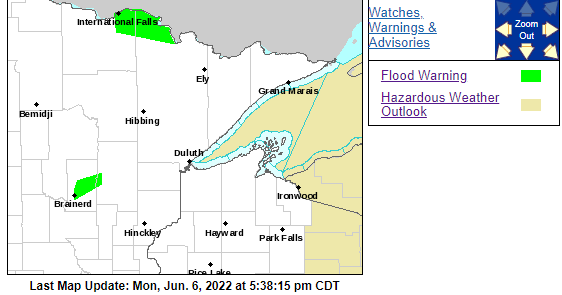
-Flood Warning now in effect until 4 PM Sunday for portions of north-central and northeast Minnesota including Koochiching and St. Louis Counties. Namakan and Rainy Lake have both surpassed levels set during the 2014 peak levels with Rainy Lake now above the 1950 record peak. The mostly dry weather over the past week has meant declining flows in the smaller streams and reduced inflows to the lakes. Flows across most of the watershed are expected to remain very high for the week ahead. Namakan and Kabetogama Lakes were at 1122.3 feet as of June 6 which is 21 inches above the peak level in 2014 and 7 inches below the 1916 peak. The level of Namakan Lake is expected to fall by 6 to 11 inches between June 6 and June 13. Rainy Lake was at 1113.1 feet as of June 6 which is 21 inches above the 2014 flooding peak and 2 inches above the record peak of 1950. Rainy Lake is expected to rise by 1 to 3 inches between June 6 and June 13. A peak is unlikely before mid-June on Rainy Lake regardless of precipitation patterns. Some locations that will experience flooding include International Falls, Kabetogama, Crane Lake, Kabetogama Lake, Voyageurs National Park, Rainy Lake East, Rainy Lake West, northwestern Boundary Waters Canoe Area Wilderness, Ranier, Ray, Island View, Ericksburg, Johnson Lake, and Sand Point Lake.
-Flood Warning now in effect until Saturday evening for the Mississippi River at Aitkin affecting Crow Wing and Aitkin Counties in east-central Minnesota. Minor flooding is occurring, and minor flooding is forecast. At 9:30 AM Monday the stage was 13.6 feet. Flood stage is 13.0 feet. The river is forecast to fall below flood stage Saturday morning.
The good news is that a dry weather pattern looks to continue in northeast Minnesota and northwest Wisconsin through this weekend, however, there are signs showing up in computer models for a somewhat more active pattern possibly developing next week.

Thanks for reading!
Tim
Leave a Reply