5:35 PM Monday, June 27, 2022
Local Storm Reports for June 27, 2022
Source: NWS Duluth, MN
5:19 PM: Hail 1.25″ (half dollar size). Beroun, MN (Pine County) A lot of accumulated hail on the roadway.
5:08 PM: Hail 0.88″. 2 ENE Brook Park, MN (Pine County)
4:22 PM: Hail 2.00″ (hen egg size) 7 SSE Kimberly, MN (Aitkin County)
3:40 PM: Hail 1.00″ (quarter size) 4 ENE Hassman, MN (Aitkin County)
We’ve seen some showers and thunderstorms move southeast across parts of northeast and east-central Minnesota this afternoon with the majority of these storms remaining below severe criteria, but we have seen two severe thunderstorms one passing southwest of the McGregor area and the other passing south of the Hinckley between 4-5 PM today with a few reports of large hail ranging from quarter size to hen egg size (1″ to 2″ in diameter)
The environment for today’s storms includes sufficient amounts of instability with CAPE of 1000 to 2000 J/kg, but other ingredients are lacking for a more robust severe event today, this would include less than ideal moisture content with dew points generally around 50 to 55, weak winds aloft and weak amounts of wind shear, but with the instability in place along with some warm air advection we have seen some scattered convection develop in some parts of the Northland this afternoon and this should continue at least into early this evening.
Goes-16 satellite loop showing the scattered storms affecting parts of the Northland this afternoon as noted by the yellow/orange colors which represents colder cloud tops/convection.

Radar loop ending 5:10 PM Monday, June 28, 2022.

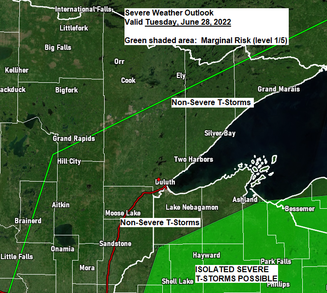
TUESDAY’S STORM RISK
A cold front will move south across the Northland on Tuesday, but the timing of this cold frontal passage looks to be from Tuesday morning through about mid-afternoon Tuesday which really isn’t ideal for getting enough instability to develop prior to the passage of this cold front, but parts of northwest Wisconsin may build up enough instability for there to be a few showers and thunderstorms with an isolated risk for strong to severe thunderstorms during the early to midafternoon on Tuesday, while northeast and east-central Minnesota could see a few showers and isolated thunderstorms mainly Tuesday morning.


The strongest signal for more widespread shower and thunderstorm coverage on Tuesday is over central into northern and northeastern Wisconsin where a later cold frontal passage should allow for greater instability to build up which then leads to a better chance for stronger convection during the mid to late afternoon Tuesday.

18z NAM 3km model simulated radar forecast through 7 PM Tuesday.

WEDNESDAY’S STORM POTENTIAL
Will see another low-pressure system move across the Northern Plains and upper Midwest Wednesday into Thursday with the cold front moving through our area Tuesday lifting back north as a warm front Wednesday, while another cold front pushes through the area Thursday.
This midweek system offers a slightly greater chance for severe thunderstorms in parts of the Northland if we can get enough moisture to return ahead of this system.
There looks to be sufficient instability for storms to tap into on Wednesday, and much stronger winds aloft and more favorable wind shear as well, and lapse rates also look fairly steep at the moment, so when you combine all of these ingredients then this could lead to a few severe thunderstorms especially from Wednesday evening into early Thursday morning.


With only a few days left in June let’s take a look at how we’re doing in terms of temperatures and precipitation in the Northland this month — Stats below are through June 26.
All of northeast Minnesota and northwest Wisconsin is running slightly warmer than average in the temperature department this month.

Average Temperature and Departure from Normal
Brainerd, MN: 67.5 F, +2.8 degrees above normal
Ashland, WI: 61.9 F, +1.4 degrees above normal
Duluth, MN: 61.9 F, +1.3 degrees above normal
International Falls, MN: 61.1 F, +0.7 degrees above normal
Hibbing, MN: 59.7 F, +1.2 degrees above normal
*5 days with a temperature of 80 or warmer at Duluth, and 1 day with a temperature of 90 or warmer. Average number of 80 degrees days at Duluth during the month of June is 5 days, and the average number of 90-degree days at Duluth in June is 0.
Rainfall totals this month have varied significantly which isn’t unusual at all for this time of the year.
Duluth has picked up over 4″ of rain so far this month while Ashland has picked up just a little over 0.75″ of rain.

International Falls has seen 125% of its normal rainfall this month while Ashland is at just 23% of its normal rainfall, in fact all of northwest Wisconsin into far eastern Minnesota has had a dry June.

Total Precipitation, departure from normal and percent of normal precipitation
Duluth, MN: 4.06″, +0.34″ above normal (109% of normal)
International Falls, MN: 4.03″, +0.80″ above normal (125% of normal)
Hibbing, MN: 3.74″, +0.05″ above normal (101% of normal)
Brainerd, MN: 2.30″, -1.11″ below normal (67% of normal)
Ashland, WI: 0.78″, -2.64″ below normal (23% of normal)
Thanks for reading!
Tim
Leave a Reply