1:52 PM Saturday, June 25, 2022
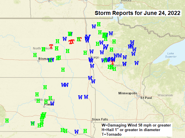
Numerous reports of wind damage, large hail and a few tornadoes with the latest round of severe thunderstorms which hit parts of North Dakota, South Dakota and Minnesota Friday into early Saturday morning.
So far there’s been 5 tornado reports with Friday’s storms, with 4 of the 5 tornado reports in North Dakota, with 1 tornado report in west-central Minnesota.
LOCAL STORM REPORTS FOR JUNE 24-25, 2022
12:46 AM 6/25/2022: Thunderstorm Wind Damage. 5 S Libby, MN (Aitkin County) Aitkin County Sheriff reports trees down over powerlines and roads.
11:50 PM 6/24/2022: Thunderstorm Wind Damage. 3 SSW Grand Rapids, MN (Itasca County) Itasca County Sheriff reports trees down over powerlines.
11:46 PM 6/24/2022: Thunderstorm Wind Damage. 2 NNE Bigfork, MN (Itasca County) Itasca County Sheriff reports trees down over the road north of Bigfork.
11:46 PM 6/24/2022: Thunderstorm Wind Damage. 2 SSW Breezy Point, MN (Crow Wing County) 1-inch tree limbs broken; shingles blown off.
11:45 PM 6/24/2022: Thunderstorm Wind Damage. 12 N Grand Rapids, MN (Itasca County) Large poplar tree down, other trees on power lines.
11:45 PM 6/24/2022: Thunderstorm Wind Damage. 4 N Breezy Point, MN (Crow Wing County) Reports multiple trees cracked and down, blocking driveway.
11:30 PM 6/24/2022: Thunderstorm Wind Damage. Marcell, MN (Itasca County) Report of trees down from Itasca County Sheriff.
11:20 PM 6/24/2022: Thunderstorm Wind Damage. 2 N Longville, MN (Cass County) Cass County dispatch reports trees down across Highway 84 at the intersection with County 126.
10:57 PM 6/24/2022: Thunderstorm Wind Damage. 2 S Walker, MN (Cass County) Area of tree damage with multiple trees snapped off, downing power lines and blocking the road.
10:55 PM 6/24/2022: Thunderstorm Wind Damage. Walker, MN (Cass County) MN Power reported at least 30 trees downed around the Walker area along with some broken powerlines.
10:42 PM 6/24/2022: Thunderstorm Wind Damage. 4 E Jenkins, MN (Crow Wing County) Multiple trees down blocking driveways.
10:28 PM 6/24/2022: Thunderstorm Wind Damage. 1 NW Bowstring, MN (Itasca County) Multiple trees uprooted or snapped off. Pontoon boat and dock flipped. Affected multiple properties on the east side of Little Jessie Lake.
Portions of northwest and north-central Minnesota picked up quite a bit of rain with Friday’s thunderstorms, while the tip of the Minnesota Arrowhead and most of northwest Wisconsin saw lesser amounts of rain Friday night/Saturday morning.

RAINFALL REPORTS FROM JUNE 24-25, 2022
McGregor, MN: 2.14″
Aitkin, MN: 2.09″
Hill City, MN: 1.88″
Duluth Airport: 1.64″
Duluth Sky Harbor Airport: 1.60″
Cass Lake, MN: 1.54″
Longville, MN: 1.49″
Saginaw, MN: 1.45″
Cloquet, MN: 1.42″
Bigfork, MN: 1.36″
Moose Lake, MN: 1.31″
Walker, MN: 1.29″
Chisholm-Hibbing Airport: 1.22″
Brainerd, MN: 1.16″
Eveleth-Virginia, MN: 0.97″
Superior Airport: 0.94″
International Falls, MN: 0.69″
Hinckley, MN: 0.66″
Littlefork, MN: 0.66″
Isabella, MN: 0.51″
Ely, MN: 0.51″
Orr, MN: 0.46″
Two Harbors, MN: 0.42″
Seagull Lake, MN: 0.26″
Glidden, WI: 0.26″
Solon Springs, WI: 0.17″
Hayward, WI: 0.15″
Minong, WI: 0.13″
Washburn, WI: 0.11″
Siren, WI: 0.09″
Clam Lake, WI: 0.06″
Thanks for reading!
Tim
Leave a Reply