12:24 PM Friday, June 24, 2022
Showers and thunderstorms are likely in the Northland later today through Saturday with a couple different rounds of rain and storms expected.
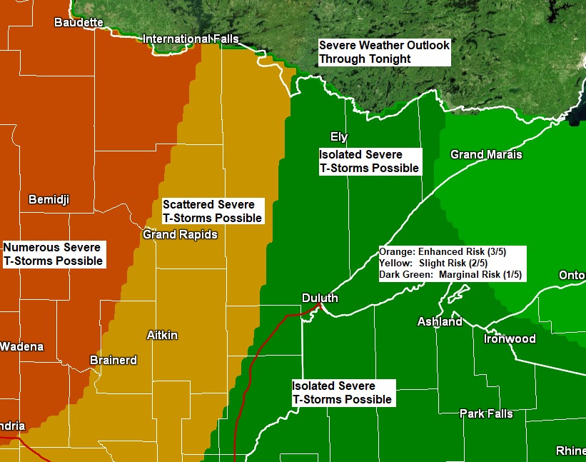
The greatest potential for severe thunderstorms later today and tonight covers western portions of the Northland including the cities of International Falls, Bigfork, Deer River, Cass Lake, Walker, Bena, Longville, Backus, Pine River, Leader and Pequot Lakes. Severe thunderstorms in these areas have a potential to produce damaging winds of 60 to 75 mph, large hail to 1″ in diameter (quarter size), with a tornado or two also possible.
The threat for severe thunderstorms diminishes farther east including for the Arrowhead, North Shore, Twin Ports, far eastern Minnesota and in all of northwest Wisconsin.
One main area of showers and thunderstorms with a chance for some severe thunderstorms is forecast to move into west-central and northwest Minnesota early this evening (after 7 PM). These storms are then forecast to move farther east into the Northland later this evening and overnight, but the severity of the storms may diminish quite a bit especially by the time they reach the Arrowhead, North Shore, Twin Ports and northwest Wisconsin later tonight.
Note: There is also a chance that we see a few showers and thunderstorms develop out ahead of the main area of storms moving east out of western Minnesota later today or this evening since there are many different boundaries over the upper Midwest, and likely a lake breeze boundary which will setup near Lake Superior later this afternoon with cooler temperatures moving into Duluth and Superior later today as winds become northeasterly.
Here’s a look at 3 different computer models valid at 10 PM Tonight.
HRW NSSL model

HRW ARW model

HRW FV3 model

Simulated radar forecast
7 PM Friday to 7 PM Saturday
12z NAM 3km model

Simulated radar forecast
7 PM Friday to 7 PM Saturday
12z HRRR model

A strong mid-upper-level trough is digging south/east out of the Pacific northwest into the northern Rockies this morning, and this trough will continue to move east passing over the upper Midwest on Saturday. Plenty of moisture and lift out ahead of this trough will help produce showers and thunderstorms over the upper Midwest through Saturday.
Goes-16 water vapor loop from Friday morning, June 24, 2022.

Very heavy rainfall amounts over parts of central Minnesota last night with a swath of 2 to 4 inches or more of rain.
Scattered pockets of heavy rain also occurred farther northeast into northeast Minnesota and far northwest Wisconsin Thursday evening.

There is a chance for heavy rain and flash flooding in the Northland through Saturday morning with the higher chances in yellow.

Widespread rainfall totals ranging from around 0.50″ to 1.50″ are possible in northeast Minnesota and northwest Wisconsin through Saturday afternoon with a chance for higher rainfall totals in some parts of the area if multiple rounds of thunderstorms occur.

HREF model continues to hint at the possibility for a rainfall maximum to setup around the Duluth area with a potential for 2-5″ or more of rain through Saturday with pockets of heavy rainfall totals scattered around the entire Northland.

ADDITIONAL STORM REPORTS FROM THURSDAY, JUNE 23, 2022
11:05 PM: Flash Flood. 5 W Pine Center, MN (Crow Wing County) Report of flash flooding 5 miles west of Pine Center near Thresing Road. Road was washed out and culverts overwhelmed.
10:21 PM: Thunderstorm Wind Damage. Rock Creek, MN (Pine County) A large aspen down across road.
10:15 PM: Thunderstorm Wind Damage. 4 ENE Pine City, MN (Pine County) Several large trees down on top of cars and at least one large maple was uprooted.
9:22 PM: Thunderstorm Wind Damage. 4 E Island Lake, MN (St. Louis County) Tree blown down crushing screen house.
8:27 PM: Thunderstorm Wind Damage. Carlton, MN (Carlton County) Winds lofted a trampoline across the yard and over a pool.
8:02 PM: Hail 2.00″ (hen egg size) 3 NNW Saint Mathias, MN (Crow Wing County)
8:00 PM: Thunderstorm Wind Damage. 4 WNW Pine Center, MN (Crow Wing County) Branches of various sizes broken.
6:15 PM: Hail 1.75″ (golf ball size) 2 N Baxter, MN (Crow Wing County) Two rounds of golf ball size hail.
Thanks for reading!
Tim
Leave a Reply