12:13 PM Monday, July 4, 2022
Some parts of the Northland picked up a decent amount of rain late last night into this morning, with over 3 inches of rain reported near Herbster, WI, while nearly 2 inches of rain has fallen at Two Harbors, while the Duluth Airport was closing in on an inch of rain through late this morning (officially 0.90″ thru 11 AM today)
Scattered rain showers and isolated thunderstorms remain possible across the Northland through early this evening, but the coverage of this rain shouldn’t be as widespread compared to what we saw in parts of the Northland earlier today.
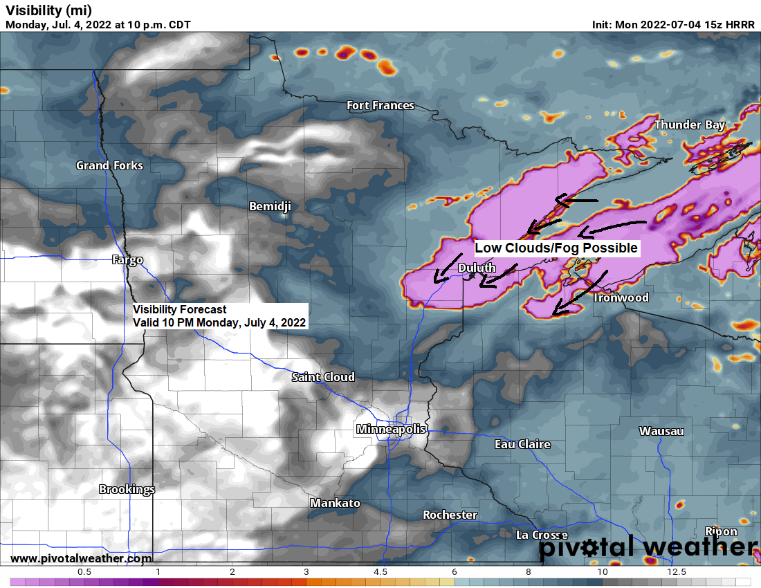
Low clouds and fog will likely be an issue near Lake Superior including in the Twin Ports through Tuesday morning, and some of this fog could become dense at times through tonight.
Note: Whether or not the low clouds and fog will be thick enough to cancel the fireworks show in Duluth and other locations near Lake Superior this evening remains to be seen, but that is definitely a possibility.
Here’s the visibility forecast through 11 PM tonight.
Lower visibilities in the pinkish colors on the animation below.

Here’s the simulated radar forecast through Midnight tonight.
Again, any additional shower or thunderstorm activity that develops in northeast Minnesota and northwest Wisconsin this afternoon and this evening should be pretty isolated in coverage.


24-Hour Rainfall Reports ending 11 AM Monday, July 4, 2022
Source: MesoWest; NWS Duluth, MN
5 S Herbster, WI: 3.30″
Hurley, WI: 2.75″
Gile, WI: 2.53″
La Pointe, WI: 2.20″
Two Harbors, MN: 1.93″
0.5 WNW Ashland, WI: 1.88″
4.6 NNE Canyon, MN: 1.85″
1 W Bayfield, WI: 1.55″
French River, MN: 1.54″
Hinckley, MN: 1.15″
Cotton, MN: 1.12″
Eveleth-Virginia, MN: 1.08″
Aurora, MN: 1.08″
Saginaw, MN: 1.08″
Duluth Airport: 0.90″
Poplar, WI: 0.82″
South Range, WI: 0.80″
Washburn, WI: 0.75″
2 N Twig, MN: 0.62″
McGregor, MN: 0.55″
Moose Lake, MN: 0.53″
Isabella, MN: 0.53″
Longville, MN: 0.52″
Duluth Sky Harbor Airport: 0.52″
Pine River, MN: 0.46″
Brainerd, MN: 0.44″
Barnes, WI: 0.40″
Glidden, WI: 0.37″
Walker, MN: 0.36″
Superior Airport: 0.27″
Siren, WI: 0.23″
Chisholm-Hibbing Airport: 0.21″
Solon Springs, WI: 0.15″
Clam Lake, WI: 0.15″
Minong, WI: 0.14″
Bigfork, MN: 0.06″
Grand Rapids, MN: 0.06″
Hayward, WI: 0.06″
Hill City, MN: 0.05″
Littlefork, MN: 0.02″
It was 92 degrees in Duluth on this date last year, but it won’t be anywhere close to that this July 4th, in fact will be lucky if temperatures climb out of the 50s near Lake Superior today, but it will be warmer farther inland with temperatures warming into the 70s to around 80 this afternoon, then falling into the 60s this evening.
Northeast wind blowing across the colder than average water of Lake Superior (water temps around 40-45 degrees) means that it will be a tad on the chilly side the closer you are to the big lake today.

Thanks for reading!
Tim
Leave a Reply