5:35 PM Monday, July 11, 2022
- Scattered showers and a few thunderstorms with brief downpours will continue into early this evening followed by mainly dry weather overnight through Tuesday morning.
- Another round of scattered showers and thunderstorms is likely Tuesday afternoon with isolated strong to severe storms possible especially over eastern Minnesota and northwest Wisconsin.
- Daytime highs mostly in the 70s Tuesday and Wednesday.
- East wind returns (cooler near Lake Superior) Wednesday-Thursday.
- Cool morning temperatures expected Wednesday morning and again Thursday morning (lows in the mid 30s to upper 40s)
- No signs of any major heat/prolonged heat wave impacting the Northland through next week.
A potent upper-level system continues to dig SE into the Great Lakes today. Lingering low-level moisture, colder temperatures aloft, and warmer air near the surface helped to build up enough instability for a day full of scattered showers and thunderstorms across the Northland. A similar setup is likely Tuesday, although the amount of moisture and instability doesn’t look quite as high as they were today, but still enough for scattered convection to develop especially given the colder temperatures aloft (around -14C at 500mb)
Goes-16 visible satellite loop from Monday, July 11, 2022.

This is a pretty potent system digging into the Great Lakes today considering the time of the year.
Goes-16 water vapor loop from Monday, July 11, 2022.

Isolated strong to severe thunderstorms are possible especially in the green shaded area Tuesday afternoon-early evening. The main severe weather threats on Tuesday include hail to 1″ diameter (quarter size), and damaging wind gusts to 60 mph.

18z NAM 3km model simulated radar forecast valid 7 AM Tuesday to 7 PM Tuesday.

Local Storm Reports from Sunday and Monday, July 10-11, 2022
Source: NWS Duluth, Minnesota
10:55 AM 7/11: Marine Thunderstorm Wind 44 mph. 6 SE Duluth, MN (St. Louis County) Measured at Duluth Sky Harbor Airport.
6:50 PM 7/10: Marine Thunderstorm Wind 39 mph. 5 NE Cedar, WI (Iron County) Measured at Saxon Harbor Wisconsin.
6:10 PM 7/10: Marine Thunderstorm Wind 47 mph. 1 N Port Wing, WI.
5:50 PM 7/10: Marine Thunderstorm Wind 51 mph. 1 N Port Wing, WI.
5:00 PM 7/10: Thunderstorm Wind Damage. 1 E Cloverdale, MN (Pine County) Report of tree down over a portion of Highway 48 east of Cloverdale.
4:39 PM 7/10: Thunderstorm Wind Damage. 3 WNW Askov, MN (Pine County) A portion of Interstate 35 southbound lane was blocked by a large fallen tree.
4:36 PM 7/10: Thunderstorm Wind Damage. 3 E Finlayson, MN (Pine County) Two large spruce trees were downed with at least one uprooted.
4:35 PM 7/10: Thunderstorm Wind Damage. Finlayson, MN (Pine County) A cluster of trees snapped near the trunk as well as a spruce tree that was uprooted.
3:18 PM 7/10: Hail 1.00 inch (quarter size) 1 SSE Breezy Point, MN (Crow Wing County)
2:55 PM 7/10: Hail 1.25 inch (half dollar size) 2 W Crosslake, MN (Crow Wing County)
1:45 PM 7/10: Hail 0.75 inch. 1 SW Crosslake, MN (Crow Wing County)
11:10 AM 7/10: Thunderstorm Wind Damage. 8 S Remer, MN (Cass County) A large tree down across a road south of Remer.
10:40 AM 7/10: Thunderstorm Wind Damage. Hackensack, MN (Cass County) A power line down near Hackensack.
A look at radar estimated rainfall totals during the 24-hour period (7 AM Sunday to 7 AM Monday)

24-Hour Rainfall Reports ending 4 PM Monday, July 11, 2022
Source: MesoWest
Eveleth-Virginia, MN: 1.59″
Hayward, WI: 0.78″
Bigfork, MN: 0.77″
Chisholm-Hibbing Airport: 0.76″
Cloquet, MN: 0.75″
Hill City, MN: 0.65″
Clam Lake, WI: 0.55″
International Falls, MN: 0.54″
Barnes, WI: 0.54″
Walker, MN: 0.52″
Solon Springs, WI: 0.44″
Littlefork, MN: 0.42″
Moose Lake, MN: 0.41″
Glidden, WI: 0.37″
Siren, WI: 0.33″
Longville, MN: 0.31″
Washburn, WI: 0.27″
Aitkin, MN: 0.26″
Ashland, WI: 0.25″
Duluth Airport: 0.22″
Two Harbors, MN: 0.21″
Superior Airport: 0.19″
Brainerd, MN: 0.18″
Cass Lake, MN: 0.17″
Duluth Sky Harbor Airport: 0.16″
Pine River, MN: 0.09″
Hinckley, MN: 0.06″
Isabella, MN: 0.06″
Ely, MN: 0.04″
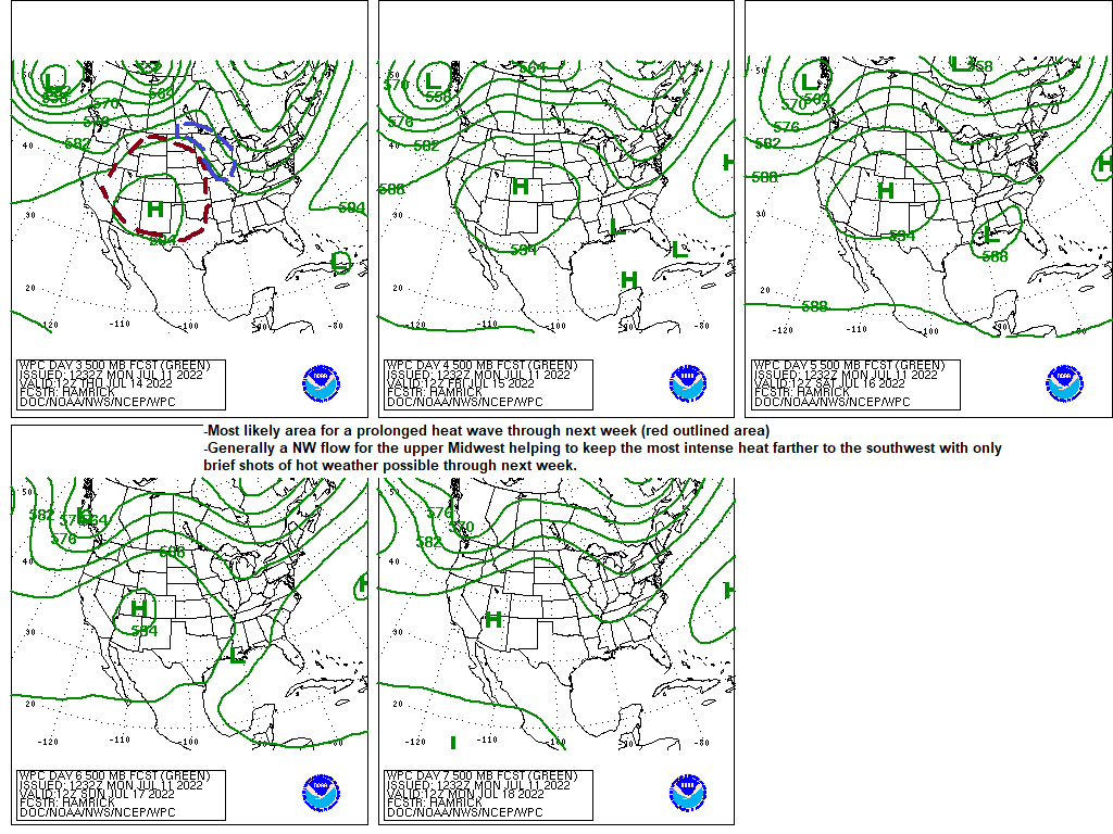
Heat will continue to be a big weather story over the next few weeks, but it continues to look like the core of the most intense/prolonged heat will remain over the Plains and not so much in the upper Midwest including for us in the Northland.
For us locally we’re looking at slightly warmer than average temperatures through next week meaning highs in the mid 70s to mid 80s with a few days mixed in with temperatures of around 90, but again I don’t see any major or prolonged heat wave impacting the Northland at least through next week the way it looks now.
Here’s next week’s temperature anomaly forecast valid July 17-22, 2022.

Thanks for reading!
Tim
Leave a Reply