12:55 PM Monday, July 18, 2022
An active weather pattern will be in place through Tuesday.
A strong mid-upper level low over the Pacific northwest this morning will move quickly to the east as it moves over the upper Midwest Tuesday night.
A nearly stationary frontal boundary will be draped over northern Minnesota through tonight, while a cold front moves east across the area Tuesday afternoon/evening.
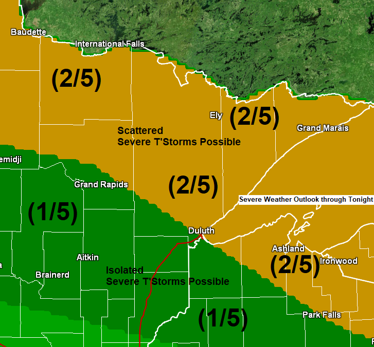
A warm, humid and unstable air mass will be in place ahead of this system, while lift provided by the frontal boundaries and upper-level system help to generate a couple rounds of scattered showers and thunderstorms in parts of the Northland through Tuesday evening.
Winds aloft will be on the strong side helping to generate a more favorable wind shear profile, this will lead to more organization to the thunderstorms which develop, and the amount of shear in place will also lead to a threat for a few strong to severe thunderstorms late this afternoon and tonight, and again on Tuesday.
Northern Minnesota into the Arrowhead have the greatest chances to be impacted by multiple rounds of storms through Tuesday evening, while chances diminish farther south including for eastern Minnesota and northwest Wisconsin, but even these areas run the risk for a few strong to severe thunderstorms should storms develop or move into these areas.
The primary severe weather threats through Tuesday evening include damaging winds to 60 mph and large hail of quarter size to ping pong ball size (1″ to 1.50″ diameter).
16z/11 AM HRRR model simulated radar forecast through 5 AM Tuesday.

This upper low centered over the Pacific northwest this morning is unusually strong considering the time of year, and this system will be moving east through early Wednesday.
Goes-16 water vapor loop from Monday, July 18, 2022.

A line of strong thunderstorms moved quickly to the southeast impacting parts of northeast Minnesota and northwest Wisconsin early Monday morning. Here’s how those storms looked via Goes-16 sandwich satellite imagery early this morning.

Local Storm Reports from Monday morning, July 18, 2022
Source: NWS Duluth, Minnesota
2:12 AM: Thunderstorm Wind Damage. 4 WNW Embarrass, MN (St. Louis County) Multiple trees down near mile marker 33 on Highway 135 N. One was a 14 inch spruce, a few 6 inch balsams, and two 6 inch popple or aspen trees.
2:00 AM: Thunderstorm Wind Damage. 4 WNW Tower, MN (St. Louis County) A couple 40 to 50 foot tall popple trees down. Another large fir tree down that knocked down a power line. Some other smaller branches and old branches down due to strong thunderstorm winds.
1:54 AM: Thunderstorm Wind Damage. 1 NW Tower, MN (St. Louis County) About 25 trees snapped or uprooted. Most of them were snapped about 6 feet above the ground. The trees varied in size, but approximately 8 to 10 inches in diameter. Generally poplar and aspen trees. Several of the trees fell on campers. A section of a dock was picked up and landed on a tent.
24-Hour Rainfall Analysis ending 7 AM Monday, July 18, 2022.

Rainfall Reports for July 17-18, 2022 (thru 12 PM Monday, 7/18)
Source: MesoWest
Hayward, WI: 1.57″
Littlefork, MN: 0.87″
Barnes, WI: 0.80″
Grand Marais, The Bay of Grand Marais, MN: 0.59″
Isabella, MN: 0.58″
Bigfork, MN: 0.49″
Orr, MN: 0.45″
International Falls, MN: 0.43″
Chisholm-Hibbing Airport: 0.29″
Duluth Airport: 0.29″
Duluth Sky Harbor Airport: 0.26″
Ely, MN: 0.26″
Eveleth-Virginia, MN: 0.25″
Two Harbors, MN: 0.20″
Clam Lake, WI: 0.20″
Washburn, WI: 0.14″
Hill City, MN: 0.13″
Saginaw, MN: 0.12″
Aitkin, MN: 0.07″
Cloquet, MN: 0.06″
Solon Springs, WI: 0.05″
Ashland, WI: 0.02″
Highest rainfall amounts through Tuesday evening are forecast to be over northern Minnesota where 1-2″+ of rain is possible per HREF model forecast.


Thanks for reading!
Tim
Leave a Reply