6:15 PM Monday, July 18, 2022
High Temperature Reports for July 18, 2022 (thru 4 PM Monday)
Ashland, WI: 92 (record high is 94 set in 1916 and 1932)
Brainerd, MN: 91 (record high is 96 set in 1932)
Duluth Airport: 89 (record high is 97 set in 1932)
Ashland was 3 degrees shy of tying their record low temperature back on July 14th (low was 40 degrees, record low 37) and fast forward to today, July 18th Ashland was just 2 degrees shy of tying their record high for July 18th (high today was 92, record high is 94).
Total Rainfall and Departure from Normal for July 2022 (thru 5 PM on the 18th)
International Falls, MN: 2.60″, +0.01″ above normal
Duluth, MN: 2.36″, -0.12″ below normal
Hibbing, MN: 2.04″, -0.48″ below normal
Ashland, WI: 1.95″, -0.27″ below normal
Brainerd, MN: 1.44″, -1.28″ below normal
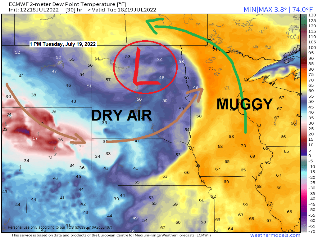
We’ve got another muggy day ahead of us on Tuesday with dew point temperatures in the mid 60s to low 70s in northeast Minnesota and northwest Wisconsin, but a much more comfortable air mass will be moving east across the Northern Plains on Tuesday, and this less humid air mass will move west to east across Minnesota Wednesday and Thursday.
Dew Point Temperature forecast through 7 PM Tuesday, July 19, 2022.

The area highlighted in orange will be the area to monitor for possible thunderstorm development tonight. The atmosphere is very unstable across the Northland late this afternoon with copious amounts of CAPE (instability) and moisture along with favorable amounts of wind shear, but so far, we haven’t seen any signs of thunderstorm development in northern Minnesota, so it’s possible will have to wait until sometime after sunset to see some storms develop.
The primary threats with these storms tonight is from large hail to ping pong ball size (1.50″ diameter) and damaging winds of 60 to 70 mph. Torrential rainfall will also occur with some of these storms tonight.

With such a strong system impacting the region on Tuesday one would think we’d be looking at a potential for a higher impact severe weather event in much of the Northland, but this probably won’t be the case with Tuesday’s setup since temperatures look awfully warm aloft which causes a cap to form in the atmosphere which will make it difficult for thunderstorms to develop.
The one exception to this may end up being across northern Minnesota into the Arrowhead where a couple rounds of strong to severe thunderstorms are possible through the day Tuesday and into early Tuesday evening, but farther south chances for strong to severe thunderstorms are a little lower including for east-central Minnesota and northwest Wisconsin due to a stronger cap vs. areas farther north, but if forcing is strong enough with the approaching surface low and cold front, then we may see a few intense thunderstorms erupt late Tuesday afternoon/early Tuesday evening across east-central Minnesota and northwest Wisconsin.
Damaging winds of 60 to 70 mph and large hail to ping pong ball size (1.50″ diameter) will be the main severe weather threats on Tuesday.

Here’s a look at the 18z NAM 3km model simulated radar forecast through 10 PM Tuesday.

Rain totals through Tuesday night will be highest across far northern Minnesota with lesser amounts of rain expected farther south.

Tuesday will be another warm day in the Northland although not quite as warm as it was for some of us today (Monday).
Highs Tuesday are forecast to be in the 80s, but a northeast wind develops near Lake Superior late tonight and continues into Tuesday with highs in the 60s and 70s on Tuesday within about 15-20 miles of Lake Superior.
The rest of the week features near normal daytime highs ranging from the upper 70s to low-mid 80s (Wednesday through Saturday)

Thanks for reading!
Tim
Leave a Reply