4:51 PM Wednesday, July 20, 2022
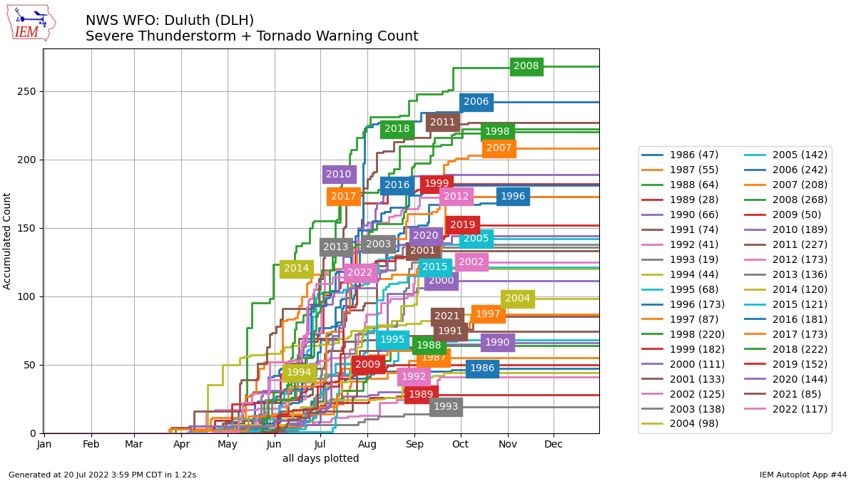
It’s been an active severe weather season in the Northland with the National Weather Service in Duluth issuing 117 severe thunderstorm + tornado warnings so far this year (through July 20). By this time last year, only 85 warnings had been issued in the Northland by the Duluth NWS.
The most warnings (severe thunderstorm + tornado) issued in the Northland by the Duluth NWS through July 20 was in 2008 with a total of 268 warnings, the least number of warnings through July 20 was in 1993 with just 19 warnings.
Monthly average temperatures in the Northland for July 2022 (thru the 19th) have been running slightly warmer to slightly cooler than normal, while warmer than normal temperatures have been more common from western to southern Minnesota.
Here are the monthly average temperatures and their departure from normal for July 2022 (thru the 19th)
Brainerd, MN: 71.2 F, +1.6 degrees above normal
Duluth, MN: 66.2 F, -0.4 degrees below normal
International Falls, MN: 65.9 F, +1.2 degrees above normal
Ashland, WI: 65.3 F, -1.0 degree below normal
Hibbing, MN: 64.2 F, +0.8 degrees above normal

Average temperature ranks by climate district for the summer of 2022 so far.
*Parts of the yellow outlined area – A top 10 warmest summer on record by climate district through July 19th.
*The areas outlined in black have seen near normal to below normal temperatures so far this summer.

A strong low-pressure system which moved across the upper Midwest on Tuesday has moved into the eastern Great Lakes region today, while upstream over the Dakotas is another disturbance which is embedded in the NW flow aloft, but this feature should pass west/south of the Northland tonight.
Goes-16 water vapor loop from Wednesday, July 20, 2022.

The disturbance moving SE out of the Dakotas may go on to produce a few showers and thunderstorms tonight mostly from west-central into southern Minnesota.
18z NAM 3km model simulated radar forecast through 7 AM Thursday.

Here’s a look at the NWS blend of models rainfall forecast through 7 AM Thursday.

Our next chance for more widespread albeit still scattered coverage rains will come on Saturday as a messy setup including a few different lows and fronts move through the upper Midwest. At the moment it looks like any severe weather associated with this system would remain over southern Minnesota into central/southern Wisconsin on Saturday, but things could change over the next few days.

Intense heat continues across the Central and Southern U.S. into parts of the western US, while a NW flow aloft continues over the upper Midwest which is helping to keep the most extreme and long-lasting heat farther to the south which has been a common theme for the summer of 2022, and looking ahead I don’t see a whole lot of change in this pattern which means that chances for a prolonged heat wave (temps of 90 or warmer) impacting northeast Minnesota and northwest Wisconsin continues to be extremely low for the rest of July.
Daytime highs in the Northland over the next few days, note the forecasted highs through this weekend are close to normal to slightly above normal for this time of the year, with Friday looking like the warmest day of the next 4 days.
Thursday 7/21: upper 70s to low-mid 80s
Friday 7/22: Mainly in the 80s
Saturday 7/23: mid 70s to low 80s
Sunday 7/24: Mainly in the 70s

Thanks for reading!
Tim
Leave a Reply