3:19 PM Saturday, July 23, 2022
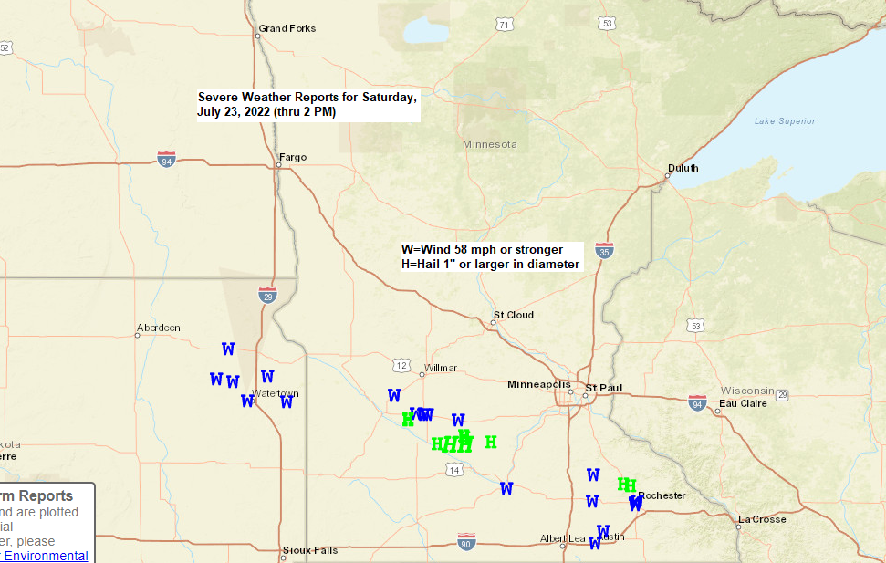
It’s been a stormy Saturday across the southern half of Minnesota thanks to a complex of strong to severe thunderstorms which has moved through that part of the state today with several reports of damaging wind gusts of up to 70 mph along with a few reports of large hail, some as big as 2 to 3 inches in diameter (hen egg to teacup size).
Goes-16 infrared satellite loop from Saturday, July 23, 2022.

Storms today across parts of the upper Midwest are developing out ahead of an approaching trough from the Northern Plains along with a surface warm front, cold front and area of low pressure.
Goes-16 water vapor loop from Saturday, July 23, 2022.

We’ve seen two main areas of more widespread heavy rain today, one has been across northwest into far northern Minnesota, and the other stretching from parts of the Dakotas into southern Minnesota.

Rainfall Reports for Saturday, July 23, 2022
Source: MesoWest
Note: Totals below through 3 PM Saturday.
International Falls, MN: 0.85″
Walker, MN: 0.34″
Littlefork, MN: 0.33″
Eveleth-Virginia, MN: 0.30″
Cass Lake, MN: 0.26″
Chisholm-Hibbing Airport: 0.19″
Brainerd, MN: 0.16″
Hinckley, MN: 0.14″
Hayward, WI: 0.08″
Siren, WI: 0.07″
Moose Lake, MN: 0.05″
Minong, WI: 0.04″
Saginaw, MN: 0.03″
Duluth Airport: 0.02″
Superior Airport: 0.01″
McGregor, MN: 0.01″
- Isolated to scattered showers and a few thunderstorms remain possible over the Northland through this evening but the threat for severe weather is very low in our area.
- Breezy and cooler Sunday with isolated brief showers possible.
- Seasonable temperatures expected during the final week of July (highs mostly in the 70s).
- Next best chance for rain comes on Tuesday.
A cold front will continue to move east across the region this evening, and this front may still produce a few showers and thunderstorms across parts of northeast Minnesota and northwest Wisconsin before Midnight, but the potential for severe thunderstorms continues to be on the low side in our area through this evening.
18z HRRR model simulated radar forecast through Midnight tonight.

A few brief showers are likely in the Northland on Sunday, otherwise we’re looking a mix of sun and clouds with a breezy NW wind with gusts to 25 mph. Highs Sunday are forecast to range from the upper 60s to middle 70s with the coolest temps found closer to the Ontario border.
Here’s the 18z HRRR model simulated radar forecast valid 7 AM Sunday to 7 PM Sunday.

Generally speaking, we’re looking at a continuation of a northwest upper-level flow across the upper Midwest through next week. This means that any prolonged heat, or even a brief shot of hot temperatures will remain well south/west of the Northland through late next week.
Blue and green – Lower 500mb heights/troughs
Orange and red – Higher 500mb heights/ridges
500mb height anomaly forecast through July 29, 2022.

Thanks for reading!
Tim
Leave a Reply