5:51 PM Thursday, August 11, 2022
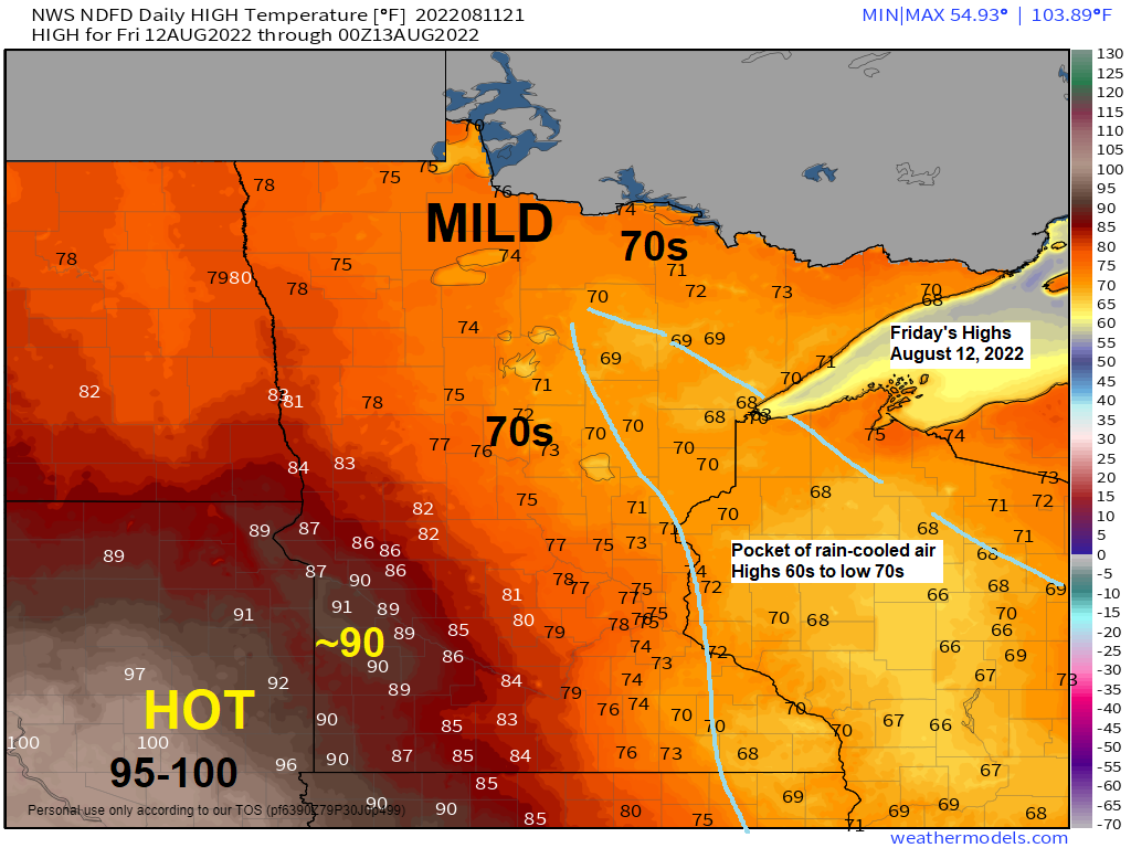
Will be seeing quite a range in temperatures on Friday with highs in the 90s in southwest Minnesota, 100s in southeast South Dakota, to the 70s in far northern Minnesota, while a pocket of rain cooled air (highs 60s to lower 70s) stretches from east-central Minnesota into central Wisconsin.
Warm air and moisture advection occurring NE of an area of low-pressure moving ESE out of South Dakota will result in some rain at times from late tonight through Friday night especially from central, southern, and eastern Minnesota into western and central Wisconsin, while mainly dry weather is expected to continue through Friday night across far northern Minnesota into the Arrowhead.
Isolated thunderstorms are possible as well Friday and Friday night mainly over parts of central, southern, and eastern Minnesota as there will be some elevated CAPE in place over those areas of the state.
Note: There continues to be some uncertainty on how far north the rain will get on Friday, but there is a chance that some of this rain will reach as far north as the Twin Ports on Friday.
NAM 3km model radar forecast valid through 7 AM Saturday.

Here’s the NWS Blend of Models rainfall forecast — The northern edge of the rain shield has pushed a little farther north compared to where it was 24 hours ago per this model forecast.

Meanwhile the SREF model shows the highest potential for >0.25″ of rain slightly farther to the south.

There will be a lot of moisture in the atmosphere on Friday with PWATS of around 1.75″ centered over central Minnesota and western Wisconsin, while a drier air mass with PWATS of generally <0.75″ will be found in northeastern Minnesota.

DROUGHT UPDATE
There has been some improvement in drought conditions in Minnesota and Wisconsin over the last week.
2% of Minnesota is in Severe Drought, down from 4% last week.
11% of Minnesota is in Moderate Drought, down from 13% last week.
28% of Minnesota is Abnormally Dry, down from 34% last week.
Note: The area outlined in black could see some more rain later tonight and on Friday.

1% of Wisconsin is in Severe Drought, unchanged from last week.
12% of Wisconsin is in Moderate Drought, down from 16% last week.
35% of Wisconsin is Abnormally Dry, down from 48% last week.

<1% of the Midwest is in Extreme Drought, down from 2% last week.
5% of the Midwest is in Severe Drought, down from 7% last week.
14% of the Midwest is in Moderate Drought, down from 18% last week.
33% of the Midwest is Abnormally Dry, down from 38% last week.

1 week drought monitor change (August 9, 2022, compared to August 2, 2022)
Areas in green saw a 1 class improvement in drought conditions.
Areas in gray saw no change.
Areas in yellow saw their drought worsen by 1 class.

Thanks for reading!
Tim
Leave a Reply