4:58 PM Monday, August 15, 2022
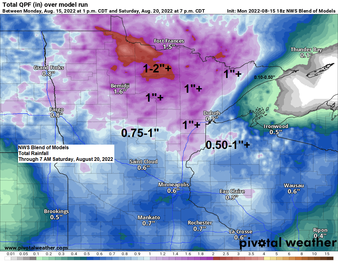
An upper-level low is forecast to develop over the upper Midwest late in the week before exiting slowly off to the east this weekend. With this upper low moving south-southeast over the area, we should see more widespread shower and isolated thunderstorm coverage in the Northland from Thursday into Friday, and possibly lingering into Saturday as well, and even before then will have chances for scattered showers from tonight through Wednesday.
Even though the forecast is full of rain chances, I don’t think any day through Saturday will be a complete washout, but chances of getting some rain from time to time are quite high for the rest of this week.
Rainfall deficits in the Northland for August 2022 (thru 4 PM on the 15th)
Duluth, MN: -1.30″ below normal
Ashland, WI: -1.25″ below normal
International Falls, MN: -0.92″ below normal
Hibbing, MN: -0.21″ below normal
Brainerd, MN: -0.10″ below normal
FOG UPDATE
Areas of fog (possibly dense) will also continue in parts of the Northland including for locations near Lake Superior tonight into Tuesday morning, and with very little change in the air mass expected for much of this week, chances that will be dealing with patchy fog are on the high side through Saturday, with the majority of this fog occurring at night and during the morning.
Here’s the 500mb height anomaly forecast valid Thursday, August 18 through Saturday, August 20, 2022.
500mb low heads SE out of Manitoba on Thursday and moves across the upper Midwest while possibly closing off for a time on Friday.

-Shower chances for tonight are highest across parts of north-central Minnesota, while scattered showers in parts of northwest Wisconsin diminish this evening.
-Showers will likely be scattered about in much of the Northland on Tuesday, with the greatest coverage of showers possibly setting up over north-central and northeast Minnesota during the afternoon/evening.
For Duluth and Superior — It looks like will stay relatively dry tonight with just some patchy drizzle possible. Chances for scattered showers increase during the day Tuesday into Tuesday evening.
NAM 3km model radar forecast through 7 AM Wednesday.

A narrow corridor of heavy rain affected parts of far eastern St. Louis and far western Lake County in northeast Minnesota Sunday afternoon through late Sunday night with radar rainfall estimates in the 1-2″+ range.

Rainfall Reports from Sunday-Monday morning, August 14-15, 2022
Source: MesoWest
Colvin Creek, MN: 1.72″
Keeley Creek, MN: 1.27″
Stony River, MN: 0.82″
Ely, MN: 0.47″
South Fork, MN: 0.33″
Crane Lake, MN: 0.30″
Two Harbors, MN: 0.24″
Winton, MN: 0.14″
Bayfield, WI: 0.12″
Schroeder, MN: 0.11″
Thanks for reading!
Tim
Leave a Reply