5:24 PM Monday, August 22, 2022
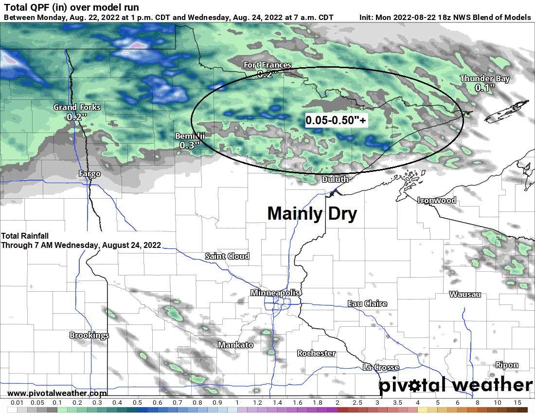
A few showers or thunderstorms are possible mostly over far northern Minnesota (north of Highway 2) this evening, but more so from late Tuesday afternoon through early Wednesday morning, but it looks like east-central Minnesota and northwest Wisconsin will remain dry at least through early Wednesday morning.
No severe thunderstorms are expected in northern Minnesota through early Wednesday morning due to a limited amount of instability along with weak winds aloft and unfavorable amounts of wind shear. Locally heavy rainfall will be the main hazard from any thunderstorm from late Tuesday into early Wednesday.
Areas of fog are possible late tonight into early Tuesday morning mainly over northern Minnesota.
Temperatures will remain on the warm side on Tuesday with highs in the upper 70s to lower 80s, but this will be followed by a cooling trend especially near Lake Superior as a stronger NE wind develops on Wednesday which will help keep high temperatures in the 60s, while inland locations warm into the 70s on Wednesday.
HRRR model radar forecast through 7 AM Wednesday.

It’s a warm day near Lake Superior today as temperatures climbed into the low 80s due to a nearly calm and or a light offshore wind direction.
For Duluth — Today, August 22 marked just the 3rd time this month with a high temperature of 80 or warmer. The last time the temperature was at least 80 in Duluth was back on August 9th (nearly 2 weeks ago) On average we typically get 8 days in August with a high temp of at least 80 in Duluth.

This month has been running cooler than normal near Lake Superior due to the abnormally chilly water temperature of the lake earlier this month which has warmed up quite a bit lately.
Much of northern Minnesota has been warmer than normal so far this month.
Here are the average monthly temperatures and departure from normal for August 2022 (thru the 21st)
Brainerd, MN: 68.6 F
Departure: +0.5 degrees above normal
International Falls, MN: 65.8 F
Departure: +2.0 degrees above normal
Ashland, WI: 65.2 F
Departure: -0.8 degrees below normal
Duluth, MN: 64.7 F
Departure: -1.6 degrees below normal
Hibbing, MN: 62.7 F
Departure: +0.2 degrees above normal

We’ve seen quite a dramatic increase in the average water temperature of Lake Superior this month, going from the low 50s earlier this month, to the low 60s here in late August which is right at normal for this time of year.

We are seeing some showers and thunderstorms (yellow and orange on animation below) over far southern Ontario this afternoon with movement of this activity to the south-southeast. Blow off or high-level clouds from those storms are making their way into extreme northern Minnesota late this afternoon, and it’s possible that will see a few isolated showers or thunderstorms in far northern Minnesota near the Ontario border this evening.
Goes-16 sandwich imagery from Monday, August 22, 2022.

Thanks for reading!
Tim
Leave a Reply