7:17 PM Saturday, August 27, 2022
Several upper-level disturbances will continue to pass through the upper Midwest through Monday.
A lead wave which brought some rain to much of the Northland earlier in the day on Saturday has moved well north of the area into Ontario this afternoon while another wave quickly approaches from the southwest as it moves northeast out of eastern Nebraska and Iowa. Most of the heavier rain and thunderstorms associated with this latter system will remain south/east of the Northland tonight.
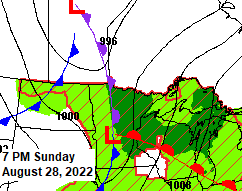
One last wave (strongest of them all) over the Northern Rockies this afternoon will move east through the upper Midwest Sunday night. This system will include an area of low pressure and a warm front and cold front which will move through the Northland Sunday night. Forcing should be stronger with this system as will have multiple surface boundaries along with an upper-level trough to help develop some showers and thunderstorms late Sunday afternoon into Sunday evening.
Goes-16 water vapor loop from Saturday, August 27, 2022.

There is a potential for a few strong to severe thunderstorms in all of northeast Minnesota and northwest Wisconsin late Sunday afternoon through Sunday evening with the highest potential in the yellow area on the map below.
The primary threats from severe thunderstorms on Sunday include large hail of quarter size to ping pong ball size (1″ to 1.5″ diameter) and damaging wind gusts to 65 mph.

Timing of storms for Sunday
It does look like much of the day Sunday will be dry in all of northeast Minnesota and northwest Wisconsin with the chance for showers and thunderstorms increasing from west to east Sunday evening.
For Duluth – Showers and thunderstorms are possible Sunday evening from around 8 PM to 11 PM.
NAM 3km model radar forecast valid 1 PM Sunday to 1 AM Monday.

HRRR model radar forecast valid 1 PM Sunday to 1 AM Monday.

Additional rainfall amounts through Sunday night.
Highest amounts of 1-3″+ from southern Minnesota into west-central Wisconsin, with most of this falling tonight through Sunday morning.
A secondary maximum in rainfall amounts of 0.50″+ is possible across north-central Minnesota late Sunday afternoon/evening.

One more humid day ahead on Sunday with dew points in the 60s across the Northland (similar to what we had on Saturday).
Lower dew point temperatures arrive on Monday.

Rainfall Reports from Saturday morning, August 27, 2022
Source: MesoWest
Deer River, MN: 0.92″
Shell Lake, WI: 0.41″
Saginaw, MN: 0.39″
Duluth Airport: 0.38″
Aitkin, MN: 0.37″
Danbury, WI: 0.37″
Spooner, WI: 0.37″
Winter, WI: 0.37″
Hayward, WI: 0.37″
Duluth Sky Harbor Airport: 0.36″
Siren, WI: 0.34″
Grand Rapids, MN: 0.32″
Webb Lake, WI: 0.31″
Hinckley, MN: 0.28″
Glidden, WI: 0.27″
Clam Lake, WI: 0.22″
Brainerd, MN: 0.21″
Solon Springs, WI: 0.20″
Esko, MN: 0.19″
Minong, WI: 0.18″
Chisholm-Hibbing Airport: 0.16″
McGregor, MN: 0.14″
Hill City, MN: 0.14″
Bigfork, MN: 0.14″
South Range, WI: 0.13″
Walker, MN: 0.13″
Cloquet, MN: 0.13″
Cass Lake, MN: 0.13″
Eveleth-Virginia, MN: 0.12″
Moose Lake, MN: 0.11″
Poplar, WI: 0.11″
International Falls, MN: 0.10″
Washburn, WI: 0.10″
Cable, WI: 0.09″
Ashland, WI: 0.08″
Aurora, MN: 0.08″
French River, MN: 0.08″
Isabella, MN: 0.06″
Cook, MN: 0.05″
Orr, MN: 0.04″
Longville, MN: 0.03″
Ely, MN: 0.03″
Two Harbors, MN: 0.01″
12-Hour radar rainfall estimates for August 27, 2022.

Thanks for reading!
Tim
Leave a Reply