6:41 PM Sunday, September 4, 2022
- Areas of low clouds/fog are possible in parts of the Northland late tonight into Monday morning, and again Monday night into Tuesday morning.
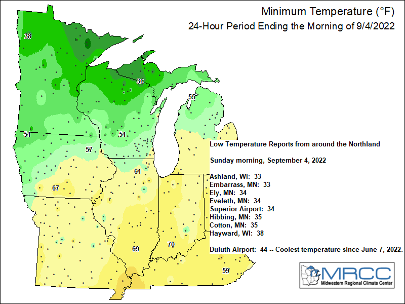
- Cool temps once again tonight although probably not as chilly as last night with lows tonight mainly in the 40s, but some 30s are possible again in the typical cold spots, but these shouldn’t be as widespread compared to what we saw Sunday morning.
- Slow warming trend the next few days with highs in the mid 60s to mid 70s on Labor Day (coolest temps near Lake Superior), highs will then range from the mid 70s to mid 80s Tuesday through Thursday.
- A cold frontal passage occurs Tuesday night, but no rain is expected as this front moves across the area.
LONG RANGE FORECAST
Well, we have quite a battle going on in the computer models for late this week/next weekend (September 9-11 time frame), but until then the weather will remain on the tranquil side in the Northland.
The differences in the computer models for later this week appear to be the result of what an upper-level trough/low decides to do as it moves into the upper Midwest late this week.
The Euro model (shown below) shows a much stronger upper trough/low closing off while drifting NE across the upper Midwest which would lead to a few rounds of rain affecting northeast Minnesota and northwest Wisconsin beginning on Friday and lasting through next weekend.
GFS model shows a much more progressive trough (a known bias with this model) with no hints of it closing off like what the Euro model shows today. This results in little to no rain affecting northeast Minnesota and northwest Wisconsin Friday through next weekend.
It must be noted the Euro model has changed drastically over just the last 24 hours when it comes to the 500mb pattern for next weekend as it went from forecasting a 588dam ridge covering the upper Midwest to a strong upper trough/low closing off with 500mb heights around 567dam per today’s run.
Here is the 500mb height anomaly per Euro model (12z run from Sunday, September 4, 2022)

And here’s the 24-hour model trend in the 500mb heights per Euro model valid for next Sunday, September 11, 2022 — Again quite a major change in the Euro model in just the last 24 hours for next weekend.

Model rainfall forecasts through 7 AM Sunday, September 11, 2022.
GFS model — Dry in all of northeast Minnesota and northwest Wisconsin.

Euro model — Widespread rain totals of 0.50-1″+, with an area of >2″ rain totals in parts of northeast Minnesota.

WESTERN US HEAT WAVE
A major heat wave will continue over much of the western US in the coming days, with the peak of this heat wave occurring in the Tuesday-Wednesday time frame, this is when we may see 500mb heights reaching 6000dam near the center of the ridge over Utah, while 500mb height anomalies of ~150 meters are possible.

Forecasted temperatures this week over much of the western US will run some +10 to +25 degrees or more above normal for early September.
Temperature anomaly valid September 5-9, 2022.

Circled areas on the map below represent locations which may break their record high temperature on the dates of this forecast which runs from September 5-9, 2022.
Note: High temps as warm as 100 to 115 degrees are likely this week in much of California.

Thanks for reading!
Tim
Leave a Reply