5:42 PM Monday, September 19, 2022
A strong cold front will be moving through the Northland on Tuesday with a potential for isolated strong storms over parts of the Northland, but behind this front will be the first real taste of fall temperatures for Wednesday and Thursday with highs both days only in the 50s to around 60. By the way the first official day of fall 2022 is Thursday, September 22, so I guess you could say that the cooling trend this week is perfect timing!
Note: Frost potential in the Northland looks highest Thursday morning and Friday morning.
Cooler than normal temperatures have been few and far between in Duluth so far this month, with only 3 days this month having a below average temperature compared to 12 days this month with an above average temperature (thru the 18th)

It’s been a very warm September over the western U.S., while an area of cooler than normal temperatures cover parts of the southern/southeast U.S.
Here in the Northland, average temps so far this month are running +2 to nearly +5 degrees warmer than average!

| Average Temperature and Departure from Normal for September 2022 (thru the 18th) Brainerd, MN: 65.9 degrees Departure: +4.8 degrees above normal Duluth, MN: 62.3 degrees Departure: +2.7 degrees above normal Ashland, WI: 61.5 degrees Departure: +1.8 degrees above normal International Falls, MN: 59.5 degrees Departure: +3.0 degrees above normal Hibbing, MN: 58.2 degrees Departure: +2.9 degrees above normal |
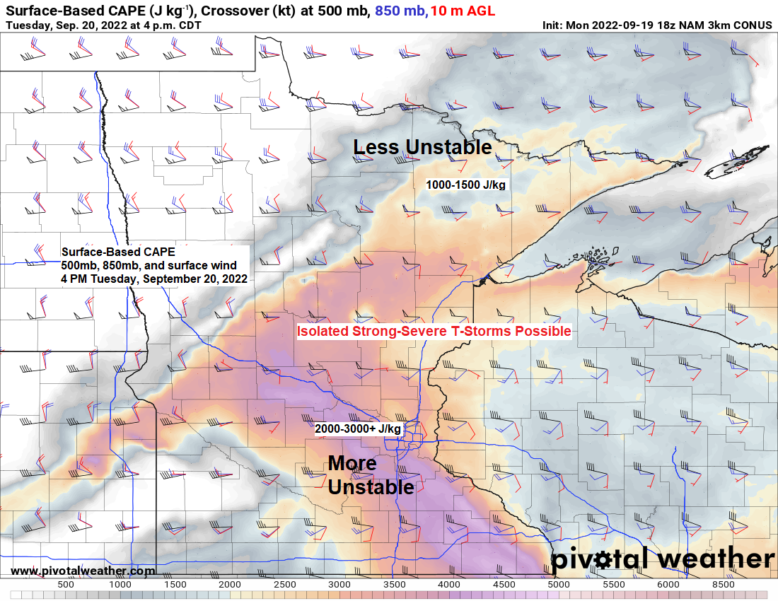
TUESDAY STORM THREAT
A cold front will move through the area on Tuesday. The air mass ahead of this front will be warm and quite humid with temperatures in the 70s to around 80, while dew point temperatures climb into the 60s over much of the Northland, with even a few 70-degree dew points possible in east-central Minnesota and far northwest Wisconsin.
Instability looks plentiful on Tuesday with CAPE ranging from 1000-3000+ J/kg with the highest values focused over central, southern and eastern Minnesota into far western Wisconsin, with lower values/less instability across northern Minnesota.
Winds aloft will be on the strong side with wind shear also on the strong side ranging from 30-50 knots on Tuesday.
Mid-level lapse rates look fairly steep per model guidance with values approaching 7.0-7.5 C/km.
Although widespread thunderstorms are unlikely in the Northland on Tuesday, there is a potential that will see isolated strong to severe storms capable of producing damaging wind gusts to 60 mph along with large hail of up to ping pong ball size (1.50″ diameter)

NAM 3km model radar forecast valid 7 AM Tuesday to 11 PM Tuesday.
Isolated thunderstorms are possible across northern Minnesota during the day Tuesday, with a chance for more robust thunderstorm development later Tuesday afternoon/evening over parts of east-central Minnesota and northwest Wisconsin.

Will have quite a shot of cold air advection between Tuesday and Wednesday.
850mb temperatures start out on the warm side (around +15 to +20C) in the Northland Tuesday.

But on Wednesday, the 850mb temperatures bottom out to the lowest we’ve seen in quite some time, with values around 0C across northern Minnesota.

LONG RANGE FORECAST
Next week’s pattern is a similar one to what we’ve seen on multiple occasions lately, with troughing to the east and ridging to the west — Looks like the Northland will be under the influence of the ridge (higher 500mb heights) more than the trough (lower 500mb heights) for much of next week.

Widespread below normal temps are forecast next week under the trough over the eastern U.S., while above normal temps are expected next week under the ridge across the western U.S. into the Plains. The Northland will be in between these two air masses with a cool start to next week possible, followed by a warming trend later next week the way it looks now.

Thanks for reading!
Tim
Leave a Reply