6:23 PM Friday, September 16, 2022
An active weather pattern continues into Saturday.
-Dense fog near Lake Superior tonight into Saturday morning, and possibly again Saturday night-early Sunday morning.
-Potential for isolated to scattered strong to severe thunderstorms Saturday afternoon and evening over parts of north-central and east-central Minnesota.
-More rain at times through Saturday night.
-The drier day of the weekend looks to be on Sunday with only isolated showers possible the way it looks now.
-Frost/freeze potential increasing late next week (~September 22-24)
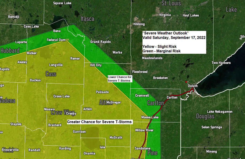
SEVERE THUNDERSTORM POTENTIAL SATURDAY
The area at greatest risk includes the following locations — Walker, Backus, Pine River, Brainerd, Remer, Hill City, Aitkin, McGregor, Moose Lake, Hinckley and Pine City.
Setup on Saturday includes a warm front over central Minnesota while an area of low pressure and cold front move east out of South Dakota.
Southerly low-level winds ahead of this system will help maintain a moist air mass with 60–65-degree dew points over much of the Northland. Low level jet looks to be out of the S-SW at around 30-40 knots, while winds higher up in the atmosphere will be out of the SW. Wind shear looks to be in the 30-40 knot range on Saturday per SREF model guidance, while the amount of instability increases to around 700-1500 J/kg (higher values if enough clearing occurs)
Note: One limiting factor for severe weather on Saturday are the mid-level lapse rates which are forecast to be around 6.0-7.0 C/km which is on the lower end of things.
The environment Saturday afternoon and evening does favor a few rotating supercell thunderstorms capable of producing large hail of up to ping pong ball size (1.50″ diameter) and damaging winds to 60 mph over southwest portions of the Northland.

0-1 KM helicity of 100 m2/s2 to around 250 m2/s2 are possible over southwest portions of the Northland early Saturday evening, this is enough to produce supercell thunderstorms.

0-1 KM EHI also favors supercell storms with values up to 3.0.

Tornado potential is more conditional late Saturday afternoon/evening, but certainly cannot rule out a tornado over central Minnesota given the setup.

Note: Although there are rain chances into early Sunday, will likely have dry times mixed in as well.
18z NAM 3km model radar forecast through 7 AM Sunday.

- Dense Fog Advisory in effect until 9 AM Saturday including the cities of Duluth, Cloquet, Mahtowa, Moose Lake, Superior, Poplar and Solon Springs.
- Visibility less than one mile in dense fog. Hazardous driving conditions due to low visibility.
- Dense fog is expected to expand this evening and will affect a large portion of the advisory area.

24-HOUR RAINFALL REPORTS for September 15-16, 2022 (ending 5 PM Friday, September 16, 2022)
Source: MesoWest
Seagull Lake, MN: 2.61″
Winton, MN: 2.36″
Ely, MN: 2.09″
Grand Marais, MN the Bay of Grand Marais: 1.22″
International Falls, MN: 1.18″
Bigfork, MN: 1.15″
Chisholm-Hibbing Airport: 1.08″
1 N Cloquet, MN: 1.00″
Isabella, MN: 0.97″
Deer River, MN: 0.94″
Orr, MN: 0.92″
Duluth Sky Harbor Airport, MN: 0.83″
French River, MN: 0.68″
Eveleth-Virginia, MN: 0.64″
Esko, MN: 0.59″
Duluth, MN (Airport) 0.55″
Two Harbors, MN: 0.54″
Cloquet, MN: 0.48″
Hinckley, MN: 0.43″
McGregor, MN: 0.39″
Hill City, MN: 0.39″
Grand Rapids, MN: 0.34″
Brainerd, MN: 0.33″
Bayfield, WI: 0.32″
Pine River, MN: 0.17″
Siren, WI: 0.16″
Minong, WI: 0.13″
Poplar, WI: 0.13″
South Range, WI: 0.12″
Washburn, WI: 0.11″
Solon Springs, WI: 0.10″
Moose Lake, MN: 0.07″
Cass Lake, MN: 0.05″
Ashland, WI: 0.04″
Here’s a look at how much more rain we may see in the Northland through Sunday morning.
1″+ totals possible in far northern Minnesota and Arrowhead region, with totals generally ranging from 0.10″ to 0.75″ over the rest of the Northland with locally higher amounts possible.

| Updated Monthly Precipitation Totals for September 2022 (thru 4 PM on the 16th) International Falls, MN: 2.12″ Departure: +0.45″ above normal Ashland, WI: 2.04″ Departure: +0.51″ above normal Duluth, MN (Airport) 1.73″ Departure: -0.17″ below normal Hibbing, MN: 1.39″ Departure: -0.35″ below normal Brainerd, MN: 0.81″ Departure: -0.52″ below normal |
FROST/FREEZE RISKS LATE NEXT WEEK
It’s looking increasingly likely that will get a pattern change at least for a brief time late next week, and this could end up producing the first widespread frost/freeze event of the season over parts of northern Minnesota and northwest Wisconsin, but before then temperatures remain on the mild side for this time of year, with afternoon temps in the mid 60s to mid 70s on Saturday, mid 60s to low 70s Sunday, and mainly in the 70s to around 80 next Monday and Tuesday, this will be followed by a cooling trend mid to late next week with highs only in the 50s possible by next Thursday.

What was once typhoon Merbok has transitioned into a powerful storm over the Bering Sea. This storm will produce damaging high winds and storm surges over southwest Alaska through Saturday.
Goes-17 water vapor loop from Friday, September 16, 2022 (ending 3:45 PM CT)

Thanks for reading!
Tim
Leave a Reply