5:46 PM Wednesday, September 21, 2022
It has begun! The stepdown process from summer to fall is here. Every cold frontal passage that occurs over the next few weeks should pack a little more punch than the previous cold front with air masses turning colder and colder with each passing cold front. This will all lead to the first frost/freeze occurring in the Northland, and eventually the first snow of the season, but that is still a few weeks away (snow that is)
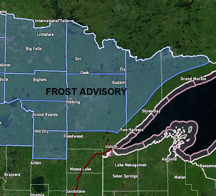
*FROST ADVISORY* issued for parts of north central and northeast Minnesota from 4 AM to 10 AM Thursday. Some cities included in the advisory — International Falls, Bigfork, Grand Rapids, Cass Lake, Walker, Hill City, Hibbing, Virginia, Cook, Orr, Crane Lake, Ely and Isabella. Temperatures as low as 32 will result in frost formation.
Lowest temperatures so far this month
Hibbing, MN: 33 on the 11th
Ashland, WI: 33 on the 4th
International Falls, MN: 34 on the 11th
Brainerd, MN: 40 on the 12th and 11th
Duluth, MN: 42 on the 11th
Mean date for first 32 degree or lower temperature
(1991-2020 climate period)
Hibbing, MN: September 10
International Falls, MN: September 15
Hayward, WI: September 19
Hinckley, MN: September 22
Ashland, WI: September 24
Brainerd, MN: September 25
Duluth, MN: September 30
Grand Marais, MN: October 3
Superior, WI: October 7
Rain chances return to the Northland later this week with some rain possible at times for Friday and Saturday, and possibly even lingering into Sunday. This rain isn’t expected to be very heavy, however, with mostly light rainfall totals the way it looks now over the 2- or 3-day period.
18z NAM 3km model radar forecast valid 7 AM Friday to 1 AM Saturday.

European model total precipitation through Saturday evening.

A northwest flow aloft will be found over the upper Midwest with a strong trough off to the east and a ridge to the west into early next week.

Below normal temperatures are expected across the upper Midwest and western Great Lakes into early next week.

There continues to be indications showing up in model guidance for a shift in the pattern mid to late next week with a trough covering the eastern U.S., while ridging builds east out of the western U.S. and Rockies.

With the approaching ridge, temperatures should respond to above normal levels once again across northern Minnesota, while near to below normal temperatures continue over northern Wisconsin from mid to late next week.
Note: There is a chance for 70-degree temperatures in parts of the Northland later next week.

Severe thunderstorms producing giant hail erupted over parts of far eastern Minnesota and west central Wisconsin Tuesday evening with cloud tops with those storms of up to 60,000 feet at times!
Here’s how those storms looked on satellite imagery (yellow and orange colors) Tuesday evening.
Goes-16 infrared satellite loop from Tuesday evening, September 20, 2022.

There were about two dozen reports of large hail of 1″ or greater in diameter Tuesday night/early Wednesday morning.
Largest hail stones last night reached 3″ in diameter or baseball size including at River Falls, WI, and also 3 miles east of Finley, WI, and 6 miles west of New Rome, WI.

Thanks for reading!
Tim
Leave a Reply