5:04 PM Monday, September 26, 2022
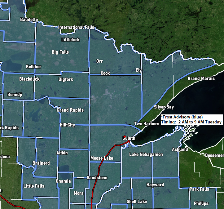
*Frost Advisory in effect from 2 AM to 9 AM Tuesday including the cities of International Falls, Bigfork, Grand Rapids, Cass Lake, Walker, Longville, Brainerd, Hill City, Aitkin, McGregor, Pine City, Hinckley, Moose Lake, Cloquet, Duluth, Hibbing, Virginia, Ely, Cook, Orr, Isabella, Superior, Solon Springs, Washburn, Bayfield, Siren, Minong, Shell Lake, Spooner, Winter and Hayward.
*Temperatures as low as 31 to 33 degrees will result in frost formation.
The next few nights will be on the chilly side in the Northland with Tuesday night looking like the coldest night as will have more favorable conditions in place for colder temps including mainly clear skies and light to calm winds. With that said we’re looking at lows in the 30s to around 40 tonight with a few 20s possible in the typical cold spots. Lows Tuesday night will be in the 20s and 30s, and there’s even a slight chance that we could see a location or two in northern Minnesota drop into the upper teens Tuesday night.
Daytime highs will be in the upper 40s to middle 50s Tuesday. 50s to around 60 Wednesday, mainly in the 60s Thursday, and then 60s to around 70 Friday and Saturday. Note: Normal highs in late September are in the low to mid 60s, and normal lows range from the mid 30s to low 40s.
A chilly air mass continues to move into the Northland today with 850mb temperatures as low as -2 to -8C just north of the border this afternoon. This chilly air mass will linger over the Northland into Tuesday before moving out mid-week.

| Average Monthly Temperatures and Departure from Normal for September 2022 (thru the 25th) Brainerd, MN: 63.8 F Departure: +4.0 degrees above normal Duluth, MN: 60.7 F Departure: +2.4 degrees above normal Ashland, WI: 59.6 F Departure: +1.2 degrees above normal International Falls, MN: 57.8 F Departure: +2.6 degrees above normal Hibbing, MN: 56.4 F Departure: +2.5 degrees above normal |
Departure from Normal Temperature for the U.S. for September 2022 (thru the 25th)
Orange and Red – Above Normal
Green – Below Normal
Yellow – Near Normal

Lowest Temperatures in the Northland so far this month
Ashland, WI: 30 on the 23rd
Hibbing, MN: 32 on the 23rd and 22nd
International Falls, MN: 34 on the 11th
Duluth, MN: 40 on 22nd
Brainerd, MN: 40 on the 12th and 11th
Pattern this week features troughing to the east and ridging off to the west — As the week progresses will see the ridge over the western U.S. move a little farther east.

The Northland will be in between the coolest temps (compared to normal) and warmest temps this week; however, the trend will be for warmer temperatures to move into our area later this week.

HURRICANE IAN
Latest update from the National Hurricane Center 5 PM ET/4 PM CT
Monday, September 26, 2022
Ian was located about 155 miles southeast of the western tip of Cuba.
Maximum sustained winds 100 mph (category 2 hurricane)
Present Movement: NNW at 13 mph
Minimum Central Pressure: 972 mb/28.71 inches
Note: Ian is forecast to approach the west coast of Florida on Wednesday into Thursday.
Ian is forecast to become a major hurricane by late tonight or Tuesday with winds >110 mph. Ian is then forecast to remain a major hurricane through late Wednesday night before slowly weakening as it moves onshore later this week (most likely on Thursday)

Zoomed in track of Hurricane Ian.
Note Ian is forecast to strengthen to a category 4 hurricane by Tuesday afternoon and then remain at a category 4 hurricane through Wednesday afternoon with wind speeds of 131 mph with maximum wind gusts near 160 mph.

Couple satellite loops of Hurricane Ian (loop times end 4:02 PM CT, Monday, September 26, 2022)
Goes-16 True Color imagery

Goes-16 visible imagery

Goes-16 infrared imagery

Storm Surge Warnings and Watches cover the west coast of Florida and parts of the northeast Florida Coast.

Peak Storm Surge of 5 to 10 feet is forecast for the Tampa Bay area.

European model 6-hour max wind gusts valid 8 AM ET/7 AM CT Tuesday through 8 AM ET/7 AM CT Saturday.

Rainfall totals of 6″+ are likely in much of Florida this week due to Hurricane Ian, with totals of 10″+ possible in parts of far western Florida.
Rainfall forecast through 7 PM Saturday, October 1, 2022.

Thanks for reading!
Tim
Leave a Reply