5:47 PM Tuesday, September 27, 2022
*Freeze Warning in effect for all of northeast Minnesota and northwest Wisconsin from Midnight tonight to 8 AM Wednesday.
*Sub-freezing temperatures as low as 28 degrees expected. Frost and freeze conditions will kill crops, other sensitive vegetation and possibly damage unprotected outdoor plumbing.
*Temperatures will likely remain above freezing for areas adjacent/near Lake Superior, but frost is still possible.

Note: Temperatures dropped to the mid to upper 20s in parts of northeast Minnesota Tuesday morning, and with a better setup in place for colder temps tonight compared to last night, I still think it’s possible that we see a location or two in northern Minnesota drop down to around 20, to possibly as low as 18- or 19-degrees Wednesday morning.
Low Temperature reports from Tuesday morning, September 27, 2022
Source: NWS Duluth, MN
2 E Celina, MN: 26 F
Cook, MN: 28 F
Floodwood, MN: 29 F
Hibbing, MN: 30 F
Orr, MN: 30 F
Aitkin, MN: 30 F
Cloquet, MN: 30 F
Siren, WI: 31 F
McGregor, MN: 32 F
Walker, MN: 32 F
Solon Springs, WI: 32 F
Two Harbors, MN: 32 F
Pine River, MN: 32 F
Bigfork, MN: 32 F
Hayward, WI: 33 F
International Falls, MN: 34 F
Grand Rapids, MN: 34 F
Spooner, WI: 35 F
Superior, WI (Airport) 36 F
Butternut, WI: 36 F
Brainerd, MN: 38 F
Ashland, WI: 38 F
Duluth, MN (Airport) 34 F, coldest temperatures since May 5, 2022 (low of 33)
A cool air mass will remain over the Northland tonight, but a warming trend is likely the next few days with highs in the 60s on Thursday, and in the mid 60s to around 70 Friday and Saturday, but we are looking at an easterly wind near Lake Superior on Saturday which will lead to cooler temperatures near Lake Superior.
As for rain chances — Isolated showers are possible in the Northland Thursday through this weekend, but widespread rains are unlikely.

The first snow of the season for Duluth may only be a few weeks away if one believes the European ensemble model.
The 50 member EPS model from September 25, 2022, shows the snow season in Duluth starting up sometime in mid-October ~15th to 20th time frame, and the 45-day snowfall forecast which runs through early November calls for snow totals ranging from a low end of 2″ to a high-end amount of ~6″.
Will see what happens!

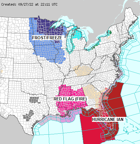
Widespread frost and freeze warnings cover the upper Midwest and western Great Lakes tonight, while fire weather concerns along with Hurricane Ian impacts parts of the southeast U.S.

A strong and deep trough covers the eastern U.S. while Hurricane Ian lifts N-NE toward Florida.
Goes-16 water vapor loop ending 5 PM CT, Tuesday, September 27, 2022.

Source: National Hurricane Center
HURRICANE IAN UPDATE
5 PM ET/4 PM CT, Tuesday, September 27, 2022
Location: About 230 miles south of Sarasota, Florida.
Maximum sustained winds: 120 mph
Present movement: north at 10 mph
Minimum central pressure: 952 mb/28.12 inches
*The center of Hurricane Ian is forecast to pass west of the Florida Keys later tonight and approach the west coast of Florida Wednesday and Wednesday night as an extremely dangerous major hurricane.
*Hurricane-force winds extend outward up to 40 miles from the center and tropical-storm force winds extend outward up to 140 miles.
*Life-threatening storm surge is increasingly likely along the Florida west coast, with the highest risk from Naples to Sarasota region.
*Hurricane-force winds are expected in the hurricane warning area in southwest and west-central Florida beginning Wednesday morning with tropical storm conditions expected overnight. Devastating wind damage is expected near the core of Ian.
Here’s the forecast track of Ian. Numbers represent the category of Ian, with a category 4 or major hurricane expected as it approaches the west coast of Florida Wednesday and Wednesday night with max winds to 115 knots/132 mph, with gusts to 140 knots/161 mph.

The center of Hurricane Ian is forecast to pass somewhere between Tampa and Cape Coral, FL (yellow line on map) Wednesday and Wednesday night, with landfall possible in the Manasota Key to Boca Grande, FL corridor sometime Wednesday afternoon.

Storm Surge Warnings remain in effect for the west coast of Florida as well as for the northeast coast of Florida.


Potential Storm Surge (Inundation layer only) from Hurricane Ian
Blue – Greater than 1 foot above ground
Yellow – Greater than 3 feet above ground
Orange – Greater than 6 feet above ground
Red – Greater than 9 feet above ground
Here’s a zoomed in view of potential storm surge for the Tampa and St Petersburg, FL area.

And for the Port Charlotte and Cape Coral, FL area.

Rainfall potential through Sunday, October 2, 2022.
Red and pink colors represent rainfall totals of 10 to 15″+

Greatest Flash Flood Risk through Friday morning, September 30, 2022.

Satellite loops of Hurricane Ian (loop times end at 4:22 PM CT, Tuesday, September 27, 2022)
Goes-16 infrared imagery

Goes-16 visible imagery

Goes-16 true color imagery

Thanks for reading!
Tim
Leave a Reply